- Thread starter
- Moderator
- #101

Follow along with the video below to see how to install our site as a web app on your home screen.
Note: This feature may not be available in some browsers.
Yep it is looking like we are headed towards a storm developing in the Atlantic. NHC confirms it.


")
Down to two at the moment, but one is moderate and the other high probability.
Meanwhile, I saw this tweet, tried to visit the Joint Typhoon Warning Center to check it out, and got the message that site might be swamped with traffic.
Anyone know more about this?
Thanks. On further look, it's probably my equipment, or rather, some issues related to a stalking problem I've got at the moment.JTWC is up for me right now
Phil
.

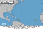
The tropical wave at 10N/35W is something that modeling shows could make it a large amount westward across the Atlantic and as a feature to watch for further development.
A lot of thunderstorm activity with this area of interest tonight. The northern Leeward islands could see a healthier system nearby this weekend.