Navigation
Install the app
How to install the app on iOS
Follow along with the video below to see how to install our site as a web app on your home screen.
Note: This feature may not be available in some browsers.
More options
-
Welcome to TalkWeather! We see you lurking around TalkWeather! Take the extra step and join us today to view attachments, see less ads and maybe even join the discussion. CLICK TO JOIN TALKWEATHER
You are using an out of date browser. It may not display this or other websites correctly.
You should upgrade or use an alternative browser.
You should upgrade or use an alternative browser.
CheeselandSkies
Member
Uuuuhhh, unless every source under the bus is wrong then
Parkersburg never had one
Nor smithville
Nor joplin
Which is news too me…
I guess I always assumed Smithville must have had one because the affected NWS offices were handing them out on 4/27 like candy on Halloween (and rightfully so).
Kds86z
Member
tornado examiner
Member
Train cars should be added as an official DI or series of DI’s on the revised EF-scale. I'm positive they can find a way to list it out.
Train cars are common enough to be a valid official Di should they get hit.
Train cars are common enough to be a valid official Di should they get hit.
Kds86z
Member
Kds86z
Member
Really really bugs me lake city didn’t get eF4 and watching that live on chaser cams was an experience. Crazy motion.Yeah, Bakersfield and Lake City are quite obviously EF-4 structurally and contextually. Even more so now that Vehicle damage/Object lofting has been now used as an EF-5 damage indicator. Gary could be upgraded but that one's more iffy. Your stance on Selmer is respectable too.
Other than those, the higher end tornadoes have been generally more well rated this year. Marion could be a little lower and Tylertown could be a bit higher though, just my opinion.
I just chalk that one up to “MEG going to MEG.” Jackson, Huntsville, and Birmingham got the memo that day and all handed tornado emergencies out accordingly.I guess I always assumed Smithville must have had one because the affected NWS offices were handing them out on 4/27 like candy on Halloween (and rightfully so).
After weeks of engineering analysis, informed largely by a new technique developed by Western University’s Canadian Severe Storms Laboratory (CSSL), a tornado that hit Enderlin, North Dakota this summer has been officially rated EF5 by the US National Weather Service (NWS), the highest category on the Enhanced Fujita (EF) scale.
This historic rating was made possible through the application of cutting-edge research by researchers at the Northern Tornadoes Project (NTP), which provided the scientific foundation for confirming wind speeds exceeding 210 mph (338 km/h).
The NWS reports that this EF5 tornado is the first of its kind in the United States since the Moore, Oklahoma tornado in 2013 and ties the EF wind speed record with the 2011 El Reno, Oklahoma tornado.
“This case exemplifies the importance of integrating engineering analysis and scientific research into operational meteorology,” said Connell Miller, director of the Northern Mesonet Project and former NTP wind impacts researcher. “Our work demonstrates that extreme wind events can be reliably assessed using forensic evidence to improve wind speed estimates in tornadoes.”
[...]
The National Westher Service’s use of this research underscores its significance for future tornado assessments, offering a powerful new tool for rating storms that produce extreme yet unconventional damage,” said Miller. “CSSL and NTP remain committed to advancing tornado science and supporting operational meteorology through innovative engineering methodologies.
It's hard to overstate how important the Enderlin tornado rating really is for the future of tornado research. This might just be the new best method for rating tornadoes. There's no reason we can't find objects that were lofted and start doing our own community analysis of previous tornadoes. Especially because it looks like @Ozonelayer is capable of doing the calculations.
Interesting diversity of thought on last night’s WeatherBrains discussing the Enderlin tornado. Rick Smith (NWS Norman Warning Coordinator) said his office, along with Paducah, Birmingham, and Jackson MS were consulted late in the process by Grand Forks. Some issues the offices raised such as how is this going to change the process going forward? The other is are they going to revisit other tornados in the past that impacted train cars? He also, half jokingly, mentioned that before he retired, he was going to make sure to get El Reno 2013 upgraded, as well as 2011’s Goldsby and Chickasha EF4s. He discussed the process of rating the 2011 El Reno tornado using a combination of the oil rig and DOW measurements, which set some of the precedent for the Enderlin upgrade.
John Gordon (former NWS Louisville MIC) was all on board with reanalysis to make sure the record is correct. Brought up Hurricane Andrew being upgraded 20 years later, as well as the AMS’ investigation of the world record highest earth temperature in Libya that turned out to be incorrect. Gordon also gave huge props to Grand Forks for pursuing this so aggressively and getting it right. Troy Kimmel, a regular WeatherBrains panelist, didn’t necessarily agree with going back and reanalyzing because it’s just going to add more confusion to an already confusing process.
John Gordon (former NWS Louisville MIC) was all on board with reanalysis to make sure the record is correct. Brought up Hurricane Andrew being upgraded 20 years later, as well as the AMS’ investigation of the world record highest earth temperature in Libya that turned out to be incorrect. Gordon also gave huge props to Grand Forks for pursuing this so aggressively and getting it right. Troy Kimmel, a regular WeatherBrains panelist, didn’t necessarily agree with going back and reanalyzing because it’s just going to add more confusion to an already confusing process.
tornado examiner
Member
It's hard to overstate how important the Enderlin tornado rating really is for the future of tornado research. This might just be the new best method for rating tornadoes. There's no reason we can't find objects that were lofted and start doing our own community analysis of previous tornadoes. Especially because it looks like @Ozonelayer is capable of doing the calculations.
Manhole covers and parking stops need to be evaluated.
Here's some more examples of 200 mph+ winds. Keep in mind, the study found there was a 0% chance sub 200 mph winds could throw a truck 80-100 meters.
Lake Martin, AL 2011
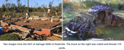
Bridgeport, AL 2011 threw a semi truck over 100 yards
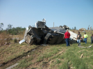
Lawrence, AL 2008
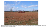
Cullman, AL 2011
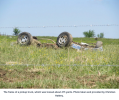
Ringgold, GA 2011 every car from these residences was thrown with some traveling at least 110 yards
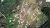
Little Rock, AR 2011 here's a good before and after of a pickup and tree (with rootball) that were thrown
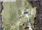
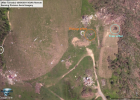
Lake Martin, AL 2011

Bridgeport, AL 2011 threw a semi truck over 100 yards

Lawrence, AL 2008

Cullman, AL 2011

Ringgold, GA 2011 every car from these residences was thrown with some traveling at least 110 yards

Little Rock, AR 2011 here's a good before and after of a pickup and tree (with rootball) that were thrown


DanLarsen34
Member
Smithville may not have had one because 1) that tornado occurred early in the event just as things were really taking off, and 2) the storm did cycle just before entering town. It has to be one of the fastest tornadoes to go from starting to reaching EF-5 intensity.I guess I always assumed Smithville must have had one because the affected NWS offices were handing them out on 4/27 like candy on Halloween (and rightfully so).
That literally makes no sense, with all due respect. It's applying a constant standard through the record (or attempting to do so), which makes things easier going forward.Interesting diversity of thought on last night’s WeatherBrains discussing the Enderlin tornado. Rick Smith (NWS Norman Warning Coordinator) said his office, along with Paducah, Birmingham, and Jackson MS were consulted late in the process by Grand Forks. Some issues the offices raised such as how is this going to change the process going forward? The other is are they going to revisit other tornados in the past that impacted train cars? He also, half jokingly, mentioned that before he retired, he was going to make sure to get El Reno 2013 upgraded, as well as 2011’s Goldsby and Chickasha EF4s. He discussed the process of rating the 2011 El Reno tornado using a combination of the oil rig and DOW measurements, which set some of the precedent for the Enderlin upgrade.
John Gordon (former NWS Louisville MIC) was all on board with reanalysis to make sure the record is correct. Brought up Hurricane Andrew being upgraded 20 years later, as well as the AMS’ investigation of the world record highest earth temperature in Libya that turned out to be incorrect. Gordon also gave huge props to Grand Forks for pursuing this so aggressively and getting it right. Troy Kimmel, a regular WeatherBrains panelist, didn’t necessarily agree with going back and reanalyzing because it’s just going to add more confusion to an already confusing process.
Speaking of Kentucky, one tornado that could probably use an upgrade to EF4 is Bowling Green from 12/10/2021.
This whole logic of "we shouldn't use other data or techniques to correct the record when it would introduce inconsistencies" is a fallacy, when the current method has already shown to be inconsistent. Yes, the ratings back in the 1950s-70s are probably skewed too high (and probably can be reanalyzed too), but that doesn't mean you don't correct modern tornadoes.
tornado examiner
Member
do you think nws Des moine would upgrade Greenfield based on the lateral movement of several parking stops?
Windspeed calcs for those come up to around 247mph and it's not a completely isolated incident. Yeah assumptions have to be made but it is interesting too note. Greenfield is now very much an edge case EF5 for me with this new contextual based forensics surveying method being officially viable.
Windspeed calcs for those come up to around 247mph and it's not a completely isolated incident. Yeah assumptions have to be made but it is interesting too note. Greenfield is now very much an edge case EF5 for me with this new contextual based forensics surveying method being officially viable.
Yeah, agreed, it was quite the difference in opinion when Spann asked if it should open the door for historical reanalysis with Kimmel immediately saying “I hope not” and Gordon responding with “I think it is.”That literally makes no sense, with all due respect. It's applying a constant standard through the record (or attempting to do so), which makes things easier going forward.
Speaking of Kentucky, one tornado that could probably use an upgrade to EF4 is Bowling Green from 12/10/2021.
Agreed on Bowling Green. Was there anything in the very long track Dresden TN EF3 that preceded Bowling Green that could be looked at for a possible upgrade as well?
I am 100% convinced now that LZK flat out a) ignored multiple EF5 candidate homes in Vilonia and omitted them from DAT and b) used gymnastics to rate actual EF5 damage (Wicker Street) EF4 in order to decrease the media/etc. attention away from yielding the first official EF5 in AR history. It's really difficult to come to any other conclusion at this point.
tornado examiner
Member
They have zero excuse’s now.I am 100% convinced now that LZK flat out a) ignored multiple EF5 candidate homes in Vilonia and omitted them from DAT and b) used gymnastics to rate actual EF5 damage (Wicker Street) EF4 in order to decrease the media/etc. attention away from yielding the first official EF5 in AR history. It's really difficult to come to any other conclusion at this point.
CheeselandSkies
Member
I am 100% convinced now that LZK flat out a) ignored multiple EF5 candidate homes in Vilonia and omitted them from DAT and b) used gymnastics to rate actual EF5 damage (Wicker Street) EF4 in order to decrease the media/etc. attention away from yielding the first official EF5 in AR history. It's really difficult to come to any other conclusion at this point.
We've known this for years, since not long after the tornado occurred that it was an ominous precedent for future surveys of high-end violent tornadoes.
Interesting diversity of thought on last night’s WeatherBrains discussing the Enderlin tornado. Rick Smith (NWS Norman Warning Coordinator) said his office, along with Paducah, Birmingham, and Jackson MS were consulted late in the process by Grand Forks. Some issues the offices raised such as how is this going to change the process going forward? The other is are they going to revisit other tornados in the past that impacted train cars? He also, half jokingly, mentioned that before he retired, he was going to make sure to get El Reno 2013 upgraded, as well as 2011’s Goldsby and Chickasha EF4s. He discussed the process of rating the 2011 El Reno tornado using a combination of the oil rig and DOW measurements, which set some of the precedent for the Enderlin upgrade.
John Gordon (former NWS Louisville MIC) was all on board with reanalysis to make sure the record is correct. Brought up Hurricane Andrew being upgraded 20 years later, as well as the AMS’ investigation of the world record highest earth temperature in Libya that turned out to be incorrect. Gordon also gave huge props to Grand Forks for pursuing this so aggressively and getting it right. Troy Kimmel, a regular WeatherBrains panelist, didn’t necessarily agree with going back and reanalyzing because it’s just going to add more confusion to an already confusing process.
This whole logic of "we shouldn't use other data or techniques to correct the record when it would introduce inconsistencies" is a fallacy, when the current method has already shown to be inconsistent. Yes, the ratings back in the 1950s-70s are probably skewed too high (and probably can be reanalyzed too), but that doesn't mean you don't correct modern tornadoes.
I have to imagine the internal politics (for lack of a better word) on this are going to get very heated and messy. It's one thing to go back and correct one hurricane 20 years later, but we are talking about potentially dozens of tornadoes that are improperly rated here. I think the questions are going to be 1) Do we actually go back and change all these EF ratings and deal with the PR nightmare that will cause? 2) Do we adjust the existing brackets upwards on the current scale to more realistic wind speed estimates, and keep most of the ratings the same? 3) Do we backtrack to the original Fujita scale and change all the EF ratings back to F ratings? 4) Do we invent an entirely new system and convert everything to that, with a herculean effort matching what Thomas P. Grazulis did with the original F scale?
Do those cover it? I don't see any other options. There isn't a single solution that isn't extremely complicated with plenty of downsides. It's going to have to be decided at some point. They may as well make the decision this winter, and start moving in that direction, so we can avoid making an already terrible mess worse (with another tornado season of bad data). Now that we know what we know, it's not like we can just keep the incorrect data the way it is. Has science ever allowed that to happen in history? lol
I've been shouting about incorrect tornado ratings for so long I've barely stopped to think about what the actual best solution for fixing this mess is.
