
TornadoFan
Member
It hasn't been updated yet.
Follow along with the video below to see how to install our site as a web app on your home screen.
Note: This feature may not be available in some browsers.
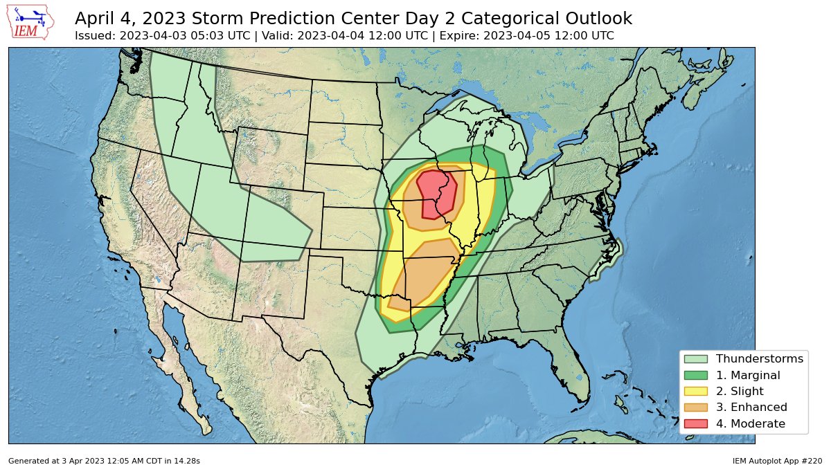
GotchaCOD has updated and has a D2 tornado driven moderate


There remains a significant convective signal on the Euro roughly encompassing the current D2 MDT zone, in a highly favorable parameter space. It has been very consistent with this.
LONG TERM...(Tuesday through Sunday)
Issued at 258 AM CDT Mon Apr 3 2023
Key Messages
1. Significant severe weather outbreak possible tuesday with
multiple rounds of storms.
2. Quiet and cooler through the end of the week and into the weekend.
3. System will bring chances for precip to start next week.
Discussion:
Moderate risk for severe weather again for our area on Tuesday as a
volatile setup looks to be taking shape. The environment is primed
for significant severe storms.
A deep upper level trof will dig into the central CONUS during the
day. At the same time, the subtropical and polar jet streams look
to merger over our area near 00z Wednesday. This bifurcated flow
will have its exit region located over the warm sector into our
area. At the same time, strong WAA and moisture return will help to
bring warm, moist air to the region. A H5 jet streak is forecast to
move into our area again late afternoon. Also, the H85 jet is
expected to ramp up after 00z as well. All of this combines to
create largescale lift over an unstable warm sector.
A warm front is expected to be draped across the area during the day
and will eventually move north the low and upper level flow moves
into the area. Low level winds are not as impressive during the
day, but deep layer shear says supercells would be the storm mode.
The RAP also has a dryline that may move into the area during the
afternoon and may serve as a foci for thunderstorm development. All
ingredients are there for storms to develop in a CAPE and shear rich
environment.
While the warm sector is large, there is CAP in place as traditional
loaded gun soundings are found across the area. This will keep
storm development during the day tied to any weak ripples in the
flow. Overall coverage before 00z should be low. Storms that do
develop in the warm sector will likely move around 30 to 40 mph, so
slow compared to the other day, and have weaker llvl flow. They
will be capable of tornado production, but I would think with
better lapse rates and 0-6km shear would be good hail producers.
Once the LLJ kicks in, and the upper level flow arrives, the
tornado threat will increase dramatically. Storms will also
increase in coverage and speed. CAMs have the CAP holding strong,
but think largescale forcing could be enough to get things going
later in afternoon into early evening. Supercells would be likely
and with not as strong of a forcing as friday they may stay
isolated. The cold front will swing in behind this and produce a
line of strong to severe storms again. Overall we could see up to
three rounds of severe weather on Tuesday into the overnight.
The first round, Tuesday afternoon, isolated in nature supercell
that if it gets close to warm front could produce a strong tornado,
otherwise mostly hail. A second event, in the evening that could
possibly be widespread supercells with strong tornadoes. Then the
front, which could be overnight with severe wind and embedded QLCS
tornadoes. We need to watch CAM runs today to really get a good
idea of trends and what may happen. Regardless, the environment is
primed for high end severe weather again. We must remain vigilant
and stay tuned to the forecast again.
I’m actually kind of surprised they put out a Moderate already, though if one or two cells were able to mature in that OWS it would be worthy of a moderate riskI’m not the biggest believer in the long-range HRRR, but the 12z run does reflect some of the concerns about capping and high LCLs staving off OWS convection, and it really only shows substantial convection in the immediate vicinity of the warm front.
Yeah I mean the ceiling is obviously very high but the floor is much lower, especially compared to Friday.I’m actually kind of surprised they put out a Moderate already, though if one or two cells were able to mature in that OWS it would be worthy of a moderate risk
Too many issues to consider...The 12z NAM actually tracks pretty well with the discussion from the Quad Cities NWS, the OWS stays capped thru 0z but then the cap erodes (especially in proximity to the dry line) which might open the window for some discrete convection. I’m not sure the long-range CAM runs that don’t convect at all along the dry line are realistic. One other thing I’m noticing on the forecast soundings is some VBV in the wind profiles, which might be another issue to consider.
Really makes you appreciate the significance of Friday. I remember us discussing if the CAMS were on crack printing that many supercells and UH streaks. Little did we know they were on to something and in agreement on something significant occurring.Too many issues to consider...
Really makes you appreciate the significance of Friday. I remember us discussing if the CAMS were on crack printing that many supercells and UH streaks. Little did we know they were on to something and in agreement on something significant occurring.
