- Thread starter
- #141
KevinH
Member
“Predictability is too low” for Fri 3/3 (D8) per the SPCs D4-8 outlook this morning.
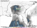
...Tuesday/Day 5 to Friday/Day 8..
A cold front is forecast to move into the Gulf Coast states on
Tuesday, as a shortwave trough moves through the Rockies. Moisture
return on Tuesday is forecast to remain largely absent ahead of this
trough, suggesting the potential for severe thunderstorms will
remain low. On Wednesday, some moisture is forecast to advect
northward into the Gulf Coast states, where isolated to scattered
convection will be possible during the afternoon. However, model
solutions suggest that instability will remain weak, limiting the
severe weather potential. On Wednesday night into Thursday,
continued moisture advection should increase surface dewpoints up
into the 60s F from Georgia into the Carolinas. Although
thunderstorms will be possible near the axis of a low-level jet, the
weak instability that is currently forecast could be problematic.
From Thursday night into Friday, a shortwave trough is forecast to
move eastward from the southern Plains eastward across the Gulf
Coast states. Thunderstorms will be possible ahead of this feature
from the lower Mississippi Valley eastward to Florida. Although a
severe threat may develop across parts of the region, predictability
at this range remains low.