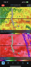
• Welcome to TalkWeather!
    We see you lurking around TalkWeather! Take the extra step and join us today to view attachments, see less ads and maybe even join the discussion.
    CLICK TO JOIN TALKWEATHER

Severe WX Severe Weather Threat - February 15-16, 2023

JayF

Technical Administrator
Staff member
Administrator
Moderator
Sustaining Member
Technical Admin
Messages
1,624
Reaction score
878
Location
Hartselle, al
HAM Callsign
KB4JCS

JayF

Technical Administrator
Staff member
Administrator
Moderator
Sustaining Member
Technical Admin
Messages
1,624
Reaction score
878
Location
Hartselle, al
HAM Callsign
KB4JCS
It will be interesting to see what happens. Some say we are done, some say not yet bc shear will increase after the sun goes down which COULD help things to fire up again.

Dixie is dynamic lol
That she is. Better to stay on guard than to say oh, it's over, and the next thing you know, boom, tornado.
 

UncleJuJu98

Member
100,000th Post
Messages
3,863
Reaction score
4,963
Location
Birmingham
It will be interesting to see what happens. Some say we are done, some say not yet bc shear will increase after the sun goes down which COULD help things to fire up again.

Dixie is dynamic lol
I think any real threat that could materliaze from the nocturnal jet will probably be south central and south Alabama but even there it's pretty low. About ready to say the threat for most of central is over. The Cullman storm has been sneaky at times but it looks to be finished.
 

KevinH

Member
Messages
1,707
Reaction score
2,678
Location
West Central GA
278
FXUS64 KBMX 162359
AFDBMX

Area Forecast Discussion
National Weather Service Birmingham AL
559 PM CST Thu Feb 16 2023

...New MESOSCALE UPDATE...

.MESOSCALE UPDATE FOR SEVERE WEATHER...
Issued at 553 PM CST THU FEB 16 2023

Convection this afternoon has struggled to organize over Central
Alabama despite favorable shear profiles and progged thermodynamics
supportive of sustained updrafts which haven't truly materialized
up to this point due to several limiting factors. Nearby PERiLS
upper air soundings have indicated that capping aloft did
eventually erode, but early onset of showers and thunderstorms and
associated convective anvil blowoff from southern Mississippi
into southwest Alabama resulted in subdued surface heating and
weaker lapse rates than anticipated across west Central Alabama
which has limited the intensity despite favorable shear profiles.
In fact, latest observed soundings and forecast guidance confirms
that the low-level jet is beginning to intensify as we head into
the evening hours leading to even more favorable shear profiles
and hodograph curvature. While shear profiles continue to support
thunderstorm organization, it appears that waning instability as a
result of poor lapse rates from congealed thunderstorms and loss
of peak heating will further limit severe potential as the
activity gradually progresses eastward. Some cells continue to
show broad rotation, so will continue to monitor for a tornado or
two over the next several hours. Also monitoring for localized
flooding as there has been some evidence of training with heavier
downpours in thunderstorm activity. Based on surface obs, the cold
front has begun to reach the AL/MS state line. Despite lingering
post-frontal showers and a few elevated thunderstorms, the severe
threat will end abruptly once the front passes by any given
location as surface winds veer sharply.
 

UncleJuJu98

Member
100,000th Post
Messages
3,863
Reaction score
4,963
Location
Birmingham
These two storms near the state border have some broad rotation to them. Good structures too

Screenshot_2023-02-16-18-16-33-39_d742e5e24846c0b0ac98c1cecc909937.jpg
 
Last edited by a moderator:

MoonBaby

Knew It Would Happen
Messages
96
Reaction score
195
Location
Mccalla, Alabama
My signal is horrible due to the rain and living basically in the woods so my radars won’t move. Is it going towards Kennedy? I know people there I need to warn if so
 

UncleJuJu98

Member
100,000th Post
Messages
3,863
Reaction score
4,963
Location
Birmingham
Tight couplet. Possibly a spin up. And it's gone the next scan! Lol these storms are one and done haha. Just like highly touted college basketball players lol

Screenshot_2023-02-16-18-38-00-32_d742e5e24846c0b0ac98c1cecc909937.jpg
 
Last edited by a moderator:
Back
Top