
Navigation
Install the app
How to install the app on iOS
Follow along with the video below to see how to install our site as a web app on your home screen.
Note: This feature may not be available in some browsers.
More options
-
Welcome to TalkWeather! We see you lurking around TalkWeather! Take the extra step and join us today to view attachments, see less ads and maybe even join the discussion. CLICK TO JOIN TALKWEATHER
You are using an out of date browser. It may not display this or other websites correctly.
You should upgrade or use an alternative browser.
You should upgrade or use an alternative browser.
Severe Weather Threat - November 29th-30th, 2022
- Thread starter Lake Martin EF4
- Start date
TornadoFan
Member
And a new warning near San Augustine, TX.
xJownage
Member
the HRRR also started it as a mess that slowly became more discrete with time. You can see the cells in LA are starting to get more organized. I expect several mergers soon, especially as our 700mb winds increase, fattening our currently somewhat skinny hodos in the southern part of the risk area.This band of storms was indicated consistently on HRRR with a more semi discrete and messy mode. Probably limiting potential to the north bit all eyes along this band and to the south afterwards
warneagle
Member
Yeah that was always what the models were indicating, just that fire hose of supercells along that axis.This band of storms was indicated consistently on HRRR with a more semi discrete and messy mode. Probably limiting potential to the north bit all eyes along this band and to the south afterwards
Gail
Member
Does anyone know if Mississippi State or any of the other colleges have released a weather balloon? I know MSU usually does on severe weather days. Just curious what their soundings showed.
New MCD for Tornado Watch #572:
Storm Prediction Center Mesoscale Discussion 1981
Severe weather, tornado, thunderstorm, fire weather, storm report, tornado watch, severe thunderstorm watch, mesoscale discussion, convective outlook products from the Storm Prediction Center.
www.spc.noaa.gov
Mesoscale Discussion 1981
NWS Storm Prediction Center Norman OK
0228 PM CST Tue Nov 29 2022
Areas affected...northeast LA into central MS
Concerning...Tornado Watch 572...
Valid 292028Z - 292230Z
The severe weather threat for Tornado Watch 572 continues.
SUMMARY...Increasing potential for severe thunderstorms and
tornadoes exists across northeast LA into central MS over the next
few hours.
DISCUSSION...Latest surface analysis indicates a corridor of
enhanced severe thunderstorm and tornado potential is in place
across northeast LA into central MS. This area has experienced
pockets of broken clouds and stronger heating, resulting in
temperatures around 75-79 F amid surface dewpoints in the 68-71 F
range. This is aiding a local max in low-level instability and STP
values have increased between 3 to 4. Regional VWP data continue to
show enlarged, favorably curved hodographs and 0-1 km SRH values
greater than 250 m2/s2. As convection spreads east/northeast into
this area, increasing potential for tornadic supercells will exist.
..Leitman.. 11/29/2022
...Please see www.spc.noaa.gov for graphic product...
ATTN...WFO...JAN...SHV...
LAT...LON 32029197 32819126 33299046 33539002 33548984 33518967
33348954 33048955 32528967 32128986 31759024 31649051
31559116 31639173 31769189 32029197
Shakespeare 2016
Member
Wow, those temperatures and dewpoints are high for this time of yearlNew MCD for Tornado Watch #572:
Storm Prediction Center Mesoscale Discussion 1981
Severe weather, tornado, thunderstorm, fire weather, storm report, tornado watch, severe thunderstorm watch, mesoscale discussion, convective outlook products from the Storm Prediction Center.www.spc.noaa.gov
brianc33710
Member
I noticed the wording says "regional outbreak still possible". They seem too uncertain for the HIGH upgrade. I saw it said "considered" the time before. Should PDS & HIGH go hand-hand? I'm just asking in general not just today.might be because how messy the warm sector appears to be already. I wasn't expecting it to be nearly this messy with such subtle forcing.
That being said, I expect a few of these cells to start sucking up all the garbage around them. I'd also keep an eye to see which updrafts become dominant of the cluster of cells in C LA right now.
xJownage
Member
They don't go hand-in-hand. That's not something I know the details of, but PDS + moderate isn't uncommon whatsoever.I noticed the wording says "regional outbreak still possible". They seem too uncertain for the HIGH upgrade. I saw it said "considered" the time before. Should PDS & HIGH go hand-hand? I'm just asking in general not just today.
TornadoFan
Member
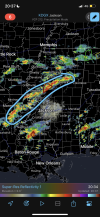
Two areas of strong rotation on the cell north of Liberty, MS.
tennessee storm chaser
Member
- Messages
- 1,877
- Reaction score
- 4,288
- Location
- jackson tennessee
- Special Affiliations
- SKYWARN® Volunteer
Know it’s early. But for know I’m not overly impressed with storms just yet central ms. Decent looking cell may be trying fire near pine bluff Arkansas maybe the start
Shakespeare 2016
Member
Not necessarily, I have seen so many moderate risks do just as well as high risks. However, like you said the really high probabilities on the PDS Tornado Watch would typically be associated with a high risk.I noticed the wording says "regional outbreak still possible". They seem too uncertain for the HIGH upgrade. I saw it said "considered" the time before. Should PDS & HIGH go hand-hand? I'm just asking in general not just today.
xJownage
Member
That far north is out of the better air tbh. Nothing looks impressive yet because this is just the first wave, and we're still waiting on the 700mb winds to strengthen, which they will over time. Weak LLLRs contribute to this too. Be patient, these storms will ramp up and organize with time.Know it’s early. But for know I’m not overly impressed with storms just yet central ms. Decent looking cell may be trying fire near pine bluff Arkansas maybe the start
warneagle
Member
The best parameters still aren't quite in place yet. That's why the focus of the action is further to the west. If you look at the CAMs, what they showed was basically a conveyor belt from southwest to northeast along the convergent boundary.Know it’s early. But for know I’m not overly impressed with storms just yet central ms. Decent looking cell may be trying fire near pine bluff Arkansas maybe the start
TornadoFan
Member
San Augustine storm is really starting to hook.
brianc33710
Member
I know. I remember Easter 2020 had at least 2 PDS Tor Watch & SPC never went HIGH. That MOD was even bigger than today's. The SPC caught grief then not only for avoiding HIGH but also not expanding MOD far enough east. I want to say Cen AL MOD underperformed and E TN, GA & CAs ENH overperformed.They don't go hand-in-hand. That's not something I know the details of, but PDS + moderate isn't uncommon whatsoever.
Jetstream
Member
fyi.......Reed catching up with the tor warned storm in central Miss. I think he's fixing to fly the drone.
CheeselandSkies
Member
1.25" hail reported at Tchula, MS with the tornado warned storm now approaching I-55. Hail isn't a feature typically associated with cool season Dixie setups.
warneagle
Member
Yeah my surprise was more that they went 95/90 on the watch and then stayed with moderate. I don't think there's necessarily a correlation between the probs and the outlook but those probs suggested a pretty high level of confidence in a higher-end event.They don't go hand-in-hand. That's not something I know the details of, but PDS + moderate isn't uncommon whatsoever.
CheeselandSkies
Member
Our current central MS bad boi looks to be turning right a bit and is in position to threaten places like Starkville, West Point and perhaps the GWX radar site down the line.