Gail
Member

Follow along with the video below to see how to install our site as a web app on your home screen.
Note: This feature may not be available in some browsers.

Warning is no surprise, those open warm sector cells could get nasty very fast
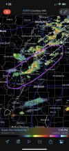
2 descreet cells, both hookingThings are now starting to get crazy. A tornado warning has been issued for southeastern Mississippi, OUTSIDE the watch box!
Unfortunately given the nature of the forcing today (driven mainly by confluence rather than the cold front) that's less likely than usual.It really does look like conditions are right for long-track storms the way things are popping up on the radar. I'm hoping it becomes too messy to really accentuate the conditions into one cell
What time is 20Z? I haven't been on here in a while so I'm a bit rusty with time translation. Its certainly warmer & more humid than this am in Hoover.Yeah I think they're probably justified in pulling the trigger at 20z. I understand their concerns about doing it at 1630, but I think their remaining questions are going to be resolved pretty soon. There's plenty of CAPE upstream that's already being advected into central Mississippi (see that LCH sounding I posted earlier) and the HRRR, etc. have been pretty consistent in establishing one or more confluence bands in the open warm sector (as noted in some of the earlier discussions here about the more subtle forcing than the typical messy Dixie Alley events).
What time is 20Z? I haven't been on here in a while so I'm a bit rusty with time translation. Its certainly warmer & more humid than this am in Hoover.


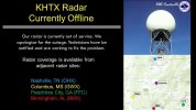
NWS HUN says KHTX could not be restarted remotely, so techs will have to go in person to Hytop to fix the issue. Thankfully, they say they have all the parts on hand to do so.