warneagle
Member
FWIW this is the first November PDS since 17 November 2013, which is not good company to be in.
Follow along with the video below to see how to install our site as a web app on your home screen.
Note: This feature may not be available in some browsers.


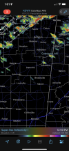
Any right mover in that kind of environment is going to be really bad news.That hodograph, though.


The warm sector remains ominously quiet still, no doubt the warm front has been able to get further north than expected quickly

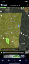
238
WFUS54 KMOB 291932
TORMOB
MSC041-292015-
/O.NEW.KMOB.TO.W.0093.221129T1932Z-221129T2015Z/
BULLETIN - EAS ACTIVATION REQUESTED
Tornado Warning
National Weather Service Mobile AL
132 PM CST Tue Nov 29 2022
The National Weather Service in Mobile has issued a
* Tornado Warning for...
Northern Greene County in southeastern Mississippi...
* Until 215 PM CST.
* At 131 PM CST, a severe thunderstorm capable of producing a tornado
was located 8 miles northeast of McLain, or 12 miles west of
Leakesville, moving northeast at 25 mph.
HAZARD...Tornado.
SOURCE...Radar indicated rotation.
IMPACT...Flying debris will be dangerous to those caught without
shelter. Mobile homes will be damaged or destroyed.
Damage to roofs, windows, and vehicles will occur. Tree
damage is likely.
* This tornadic thunderstorm will remain over mainly rural areas of
northern Greene County.
PRECAUTIONARY/PREPAREDNESS ACTIONS...
TAKE COVER NOW! Move to a basement or an interior room on the lowest
floor of a sturdy building. Avoid windows. If you are outdoors, in a
mobile home, or in a vehicle, move to the closest substantial shelter
and protect yourself from flying debris.
&&
LAT...LON 3143 8862 3143 8857 3130 8844 3114 8877
3121 8884
TIME...MOT...LOC 1931Z 230DEG 21KT 3121 8875
TORNADO...RADAR INDICATED
MAX HAIL SIZE...<.75 IN
$$