DetectiveWX
Member
Of course, our time would be a Wednesday...figures.
Follow along with the video below to see how to install our site as a web app on your home screen.
Note: This feature may not be available in some browsers.
If the models hold as week progresses, think you see James spann start to mention it …that high in Caribbean will also help pull in moisture from that region also .It looked like on Spann’s Weather Blog this morning that there was going to be a high in the Caribbean next week that would keep the worst of things west of Dixie alley and he didn’t mention any chance of storms for Southeast. Long term forecasting like this is way out of my lane, but is anyone else seeing that scenario?
Might have to include Arkansas into west ky/ tn. Depending on timing .As expected, the 00Z EPS has decidedly trended away from a low-amplitude solution and now favours high-latitude blocking and split flow. The trough axis is also much narrower on Wednesday, despite still being negatively tilted. The trajectory of moisture return prior to the main event also looks to be less favourable than on earlier runs, hence greater CAD over portions of Dixie Alley (eastern extent of warm sector), especially AL/GA. One thing is clear: UL divergence is extremely robust on the latest run and ad verbatim the setup would imply a significant event for portions of OK/KS/MO. The main threat looks to remain north and west of Dixie Alley on the latest EPS.
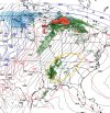
The trough is a little more amplified and a little northwest on the overnight Euro ensembles, but there hasn't been a significant/major shift. GFS ensembles have been more northwest than either the Euro ensembles or Canadian ensembles though, and that can't be ignored. But to the Euro ensembles, 576dm at 500mb has been proven for decades to be a good delineator of the south/east edge of the more substantial risk of a severe weather event, and that is through northwest MS into middle TN as early as 18z Wednesday, and into northwest AL by 00z Thu. The face value dryline by 18z Wednesday is almost completely east of Oklahoma, and that doesn't account for mixing that would likely carry the dryline farther east than shown by the lower-res globals when keeping in mind the large-scale EML plume aloft that will advect out as well as the drought over the Plains. The low-level jet is also centered over the eastern 2/3 of Arkansas, through Louisiana, southeastern Missouri, and across the river into west TN/KY by 18z Wednesday, and it is centered completely east of the MS River over IL/IN/KY/TN/MS/AL by 00z Thursday.As expected, the 00Z EPS has decidedly trended away from a low-amplitude solution and now favours high-latitude blocking and split flow. The trough axis is also much narrower on Wednesday, despite still being negatively tilted. The trajectory of moisture return prior to the main event also looks to be less favourable than on earlier runs, hence greater CAD over portions of Dixie Alley (eastern extent of warm sector), especially AL/GA. One thing is clear: UL divergence is extremely robust on the latest run and ad verbatim the setup would imply a significant event for portions of OK/KS/MO. The main threat looks to remain north and west of Dixie Alley on the latest EPS.
Is there anything showing on 4/27?I’m not saying this year is or will be anything like 2011, but is anyone else slightly nervous that it’s been an active season and 4/27 falls on a Wednesday again?? I’m sure I still have PTSD from that day so that’s probably not helping.
No idea. It’s just that day on a Wednesday again. I’ve been super, super busy at work so haven’t been keeping up with it like I’d like!Is there anything showing on 4/27?
No idea. It’s just that day on a Wednesday again. I’ve been super, super busy at work so haven’t been keeping up with it like I’d like!
Personally I think it’s trending down for the area I highlighted. The models still seem to show the atmosphere struggling to recover.I know the focus is on Iowa today but are there any thought to how tomorrow is trending? With such a large 10% hatched I thought there might be a hint in the initial Day 2 of a possible upgrade in the works but maybe no? Or just too much uncertainty still?
Sent from my iPhone using Tapatalk
Latest hrrr now picking up embedded super cells pretty far out ahead main squall line east Arkansas western/ north ms tonite afternoon . Trends keep showing that . Wouldn’t be suprise spc go moderate risk 1230 update here soon.I know the focus is on Iowa today but are there any thought to how tomorrow is trending? With such a large 10% hatched I thought there might be a hint in the initial Day 2 of a possible upgrade in the works but maybe no? Or just too much uncertainty still?
Sent from my iPhone using Tapatalk
Welcome to the weather. It is not the exact science people think it is. I am not trying to be rude, but your comments (across this forum) always come off as a bit trollish.It certainly looks as if today is turning out to be quite underwhelming compared to expectations that were voiced three or more days ago. Certainly the much-heralded low-amplitude pattern seems to have metastasised into a high-amplitude, messy, blocky pattern with considerable subtropical influence, at least in time for today’s event. When will we finally see a pattern that supports multiple, intense, long-lived tornado families over a wide area, as opposed to some QLCS-generated, semi-discrete strong tornadoes and/or an isolated discrete performer? I am not talking about all-time events like the two Super Outbreaks et al., but I am talking about events like 26 Apr 1991, 4 May 2003, Super Tuesday, Easter 2020, etc. When will we finally see a springtime pattern that generates one of those events again?