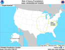
View attachment 13145 View attachment 13146 View attachment 13147
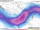
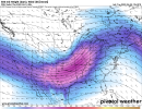
The threat of potentially significant severe weather from the big longwave upper trough next week definitely starts over the Plains and Midwest during the early portion of the week... but I am highly, woefully, from the pit of my soul, unconvinced this stays to the northwest of Dixie Alley. GFS ensembles are mixed on the idea of MS/AL/TN being targeted mid next week but several members each run consistently show the idea. Canadian and especially the Euro ensembles are consistently supporting the idea of our area here being directly targeted, with that extending north into the Ohio Valley, toward Wednesday/early Thursday of next week. With the last several systems, including this current one affecting us today and tomorrow, verifying less amplified than originally seen out in the extended, it would stand to reason that the downstream ridge may not end up as high amplitude ahead of this one as it ejects out toward the middle of next week. And that, in turn, would allow for a broader-based trough that is also able to slide more directly east instead of skirt northeast overtop the ridge and pass MS/AL/TN/GA off to the northwest. This may start as a Plains/Midwest fiasco early week, but it has Dixie Alley to Ohio Valley written all over it by mid next week.
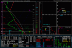
For what it's worth, there's been a steady and consistent signal for this singular specific system in the ensembles, weeklies, teleconnections, etc., for a solid month.... for this specific projected impact time, give or take 24 hours or so. I can't think of too many times a long lead-time system like that has wound up turning out to be a benign thing. We'll see...


![850wh-mean.conus[1].png](https://attachments.talkweather.com/data/attachments/13/13226-b2f06a549375d2dc44d862aacb226f47.jpg?hash=svBqVJN10t "850wh-mean.conus[1].png")
![sfcmslp-meanmem.conus[1].png](https://attachments.talkweather.com/data/attachments/13/13227-6965a50683d0ffa2378e30274a01a208.jpg?hash=aWWlBoPQ_6 "sfcmslp-meanmem.conus[1].png")
![sfctd-p105090-imp.conus[1].png](https://attachments.talkweather.com/data/attachments/13/13228-0335e21f6c4804f3fa8195a1b11b7d8e.jpg?hash=AzXiH2xIBP "sfctd-p105090-imp.conus[1].png")
![500wh-mean.conus[3].png](https://attachments.talkweather.com/data/attachments/13/13229-a37eaf28aee2318f7017683085219b5f.jpg?hash=o36vKK7iMY)