• Welcome to TalkWeather!
    We see you lurking around TalkWeather! Take the extra step and join us today to view attachments, see less ads and maybe even join the discussion.
    CLICK TO JOIN TALKWEATHER

Severe WX Severe Threat 17-18 March 2021

Tornado watch just issued for NWS Huntsville CWA, except Jackson County until midnight.

My temperature has gone up about 2 degrees since falling 1. Maybe the wedge is being overtaken by the warm front.
 
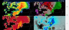
I'm not sure why the one east of Perry, GA isn't TOR, just SVR, decent rotation, impressive hook.
 
1616026258096.png

URGENT - IMMEDIATE BROADCAST REQUESTED
Tornado Watch Number 36
NWS Storm Prediction Center Norman OK
645 PM CDT Wed Mar 17 2021

The NWS Storm Prediction Center has issued a

* Tornado Watch for portions of
Alabama
Eastern Mississippi
Coastal Waters

* Effective this Wednesday night and Thursday morning from 645 PM
until 300 AM CDT.

...THIS IS A PARTICULARLY DANGEROUS SITUATION...

* Primary threats include...
Several tornadoes and a few intense tornadoes likely
Widespread damaging winds and scattered significant gusts to 80
mph likely
Scattered large hail events to 1.5 inches in diameter possible

SUMMARY...A further strengthening of low/mid-level winds this
evening will support a combination of semi-discrete supercells as
well as organizing fast-moving line segments across much of eastern
Mississippi into Alabama. Tornadoes, including a few strong, aside
from damaging winds will be the most prevalent hazards.

80/80 probs... spc seems to think that the line will be nasty. that said...the counties in MS may end up being dropped in a couple hours. weird.
 
Since the second wave in MS is not producing tornadoes will that leave the conditions more favorable for the final line of storms?
the second wave in MS that isn’t really producing much is the final line. the reality is this event Atmospheric Anti-Climax in the high risk areas of MS north of Jackson. good news. and where the storms did verify, we didn’t get the long-trackers or violent tornadoes.

certainly can’t rule them out yet, but the line in MS doesn’t look overwhelming at the moment and there isn’t very much time for storms to form ahead of the line in the area where dynamics that support long-track tornadoes exist.
There is plenty of time, and no offense, but how do you know if there wasn’t violent tornadoes? we haven’t even seen the damage and the risk didnt Forecasted Convective Amplification Deficiency. the event produced what it was gonna do. No offense yet again. and the outbreak will probably produce its main event tonight and there will be another outbreak tomorrow in another part of the country.
 
Looks to me that the line wil be arriving just as we get the low level jet punch. I could see the line breaking up into supercells. Gotta watch it closely.

HRRR has been hinting at that. That's my concern as well.
 
There is plenty of time, and no offense, but how do you know if there wasn’t violent tornadoes? we haven’t even seen the damage and the risk didnt Forecasted Convective Amplification Deficiency. the event produced what it was gonna do. No offense yet again. and the outbreak will probably produce its main event tonight and there will be another outbreak tomorrow in another part of the country.

He's talking about the high risk back into MS.
 
Back
Top