- Moderator
- #141
Next week is showing potential for maybe a more widespread and robust event.
Follow along with the video below to see how to install our site as a web app on your home screen.
Note: This feature may not be available in some browsers.
Next week is showing potential for maybe a more widespread and robust event.
The EPS has definitely trended toward a broader warm sector on Saturday/Sunday. However, the mid-level trough looks to be more positively tilted and “pinched-off” in orientation and appearance. The big takeaway is that these successive shortwaves open the door to the “reloading” in the long range and could thus set the stage for a much bigger event come the first few weeks of March. If one is looking for a singular event, one should probably focus on that timeframe, rather than the last week of February.Next week is showing potential for maybe a more widespread and robust event.
While this one has trended cutoff with time, be careful instantly turning your head away from positive tilt troughs, especially in Dixie. Trough amplitude is a lot more important than trough tilt. Many of Alabama's big tornado days (including April 8, 1998; February 5, 2008; May 18, 1995; April 4, 1977; April 3, 1974; and even March 21, 1932 if we believe the reanalysis data is close enough to correct to be accepted) were all positive tilt troughs. They were all also events with F4-F5 tornadoes in Alabama. April 3, 1974's trough started out negative tilt that morning but evolved into a positive tilt prior to any of the violent tornadoes in Alabama. Lower amplitude troughs are dangerous here, regardless of tilt. There are a whole lot of tornado deaths in this state's history to prove the idea as true.The EPS has definitely trended toward a broader warm sector on Saturday/Sunday. However, the mid-level trough looks to be more positively tilted and “pinched-off” in orientation and appearance. The big takeaway is that these successive shortwaves open the door to the “reloading” in the long range and could thus set the stage for a much bigger event come the first few weeks of March. If one is looking for a singular event, one should probably focus on that timeframe, rather than the last week of February.
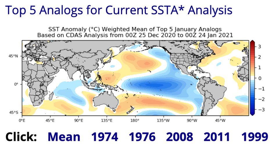
All of those analog years each had at least 1 F5/EF5. 1974 and 2011 featured super outbreaks. 1999 featured possibly the strongest tornado of all time (Moore), 2008 had Parkersburg which did extremely violent damage and had the Super Tuesday Outbreak. 1976 had 3 F5s. I am not as familiar with the 1976 season as I am the rest but definitely a concerning look.Posted this elsewhere, but I wanted to repost here to highlight a feature that I've noticed tonight upon analyzing some of the SSTA patterns with previous La Nina events.
Did some skimming of SSTA data tonight and I'm intrigued by that warm pool centered at ~150˚W and 30˚S to the south of the cold SSTAs with the Nina. Based on looking into some previous analogs around this time, it seems like that strong meridional dipole is not present in years such as 2006, 2009, 2012, 2017, and 2018 (generally quieter severe seasons especially late season). It is more prevalent in several big Nina springs though, including 1974, 1976, and 2011.
It's probably to some degree why this CDAS-derived SSTA analog product from Tropical Tidbits is essentially grouping a who's who of Nina springs with a lot of tornadoes/severe weather, including some with very large outbreaks.

You can see the SSTA dipole present in the Southern Hemisphere in the mean here.
That’s one that keeps showing up models ... has my attention also . That looks to be the beginning of the active severe pattern setting upThe storm around the 15th of this month has my attention. Still 2 weeks out but something to watch.
Moisture seems to be the BIG question mark now. Eyes will be peeledIt's starting to happen. The waves are lining up in a series, poised to take advantage of whatever moisture return occurs. The probability of severe storms and tornadoes continues to look above average for the second and third week of March assuming quality moisture is in place.
A few people on and off of this forum have said that this season will be off to a slow start. There could be some severe wether around this time next week, which is when severe season is expected to “wake up”.wow we are n the first full week march , this thread is turning into a yawn fest.
A few people on and off of this forum have said that this season will be off to a slow start. There could be some severe wether around this time next week, which is when severe season is expected to “wake up”.
It's not something you're gonna rush- that's for sure. I think it's taken time for the pattern to relax and recuperate from the mid-February cold regime that dominated the nation. That kind of large scale pattern won't turn on a dime.wow we are n the first full week march , this thread is turning into a yawn fest.
Mississippi had no tornadoes in January or February for the first time in thirty years. I don't know how the snowfall fell in that category but it was the most snow and coldest temps here in Austin since the 1980s as well.wow we are n the first full week march , this thread is turning into a yawn fest.
