• Welcome to TalkWeather!
    We see you lurking around TalkWeather! Take the extra step and join us today to view attachments, see less ads and maybe even join the discussion.
    CLICK TO JOIN TALKWEATHER

Severe Weather 2021

Fred Gossage

Member
Meteorologist
PerryW Project Supporter
Messages
596
Reaction score
2,096
Location
Florence, AL
Thanks. I was just remembering where meteorologists used graphics to talk about those things you mentioned and most of the time talked about opposing jets at different altitudes playing a part and I was just curious how intricate these analogs were.
It's a lot more complicated than that, but that's the general idea... and seeing the pattern we have now evolve into what is shown above for the end of February is essentially what we've been waiting to see. That's a transition out of the pattern with the persistent -NAO blocking and troughing in the east, into a pattern that is historically favorable for active severe weather in this region of the country. But when trying to come up with these analogs, we use the various teleconnections to try to figure out the pretty specific placement, intensity, and amplitude of the subtropical ridging, of troughing in the west... how far out it extends... and a host of other things related to the large scale pattern... and then try to see which previous years match up closely to get a basic idea of what to expect.

We know that there are a specific set of circumstances that are associated with getting active tornado patterns that target Dixie Alley. We also are starting to learn more and more that there are specific circumstances that are associated with these years that have higher-end events. Seeing evidence of that spring pattern evolve like that was the final piece of the puzzle on the large scale. From here, it will be up to individual synoptic storm systems to take full advantage of the background pattern, and then up to the mesoscale on one of those to take full advantage of the synoptic setup. That's something we don't have any way of knowing until we're coming up on one of the individual storm systems, but the larger scale setup kind of sets bounds for what the players on the scale below it can and can't do. You get something on the synoptic scale happen because there was something about the background state that allowed it to be possible. You get mesoscale features to align a certain way because there are things about the synoptic setup of a storm system that allow it.
 

Fred Gossage

Member
Meteorologist
PerryW Project Supporter
Messages
596
Reaction score
2,096
Location
Florence, AL
The euro has a system bears watching around 24. 25th. Dew points get into mid 60s parts of Dixie with plenty of wind shear work with ... could be first cool season severe threat .
Even the GFS, while not as organized looking as the Euro, has been trending back toward a more amplified solution for Monday. Pretty much everything shows that, because of the -NAO block breaking down at the end of the week, we get some low latitude subtropical ridging and decent moisture recovery in the Gulf. Instability looks marginal because the models are keeping things saturated and overcast below the EML. That almost never verifies in real life... and where the Euro has sun breaks back in Mississippi, surface temperatures get into the 70s. I think it's a legitimate threat in the sense of being the first one to have real potential. We'll just see how amplified the shortwave ends up being. That not only plays into the dynamics in shear, but also helps determine how far north across the Deep South and Tennessee Valley the warm sector is able to come. The TN state line with AL/MS seems to be the less bullish idea. The TN/KY line or into KY seems to be the solution with a stronger surface low.
 

Fred Gossage

Member
Meteorologist
PerryW Project Supporter
Messages
596
Reaction score
2,096
Location
Florence, AL
1611061835571.png 1611061856238.png
Meanwhile, with the larger scale stuff, the Euro weeklies set up the combination of a strongly negative PDO and a strongly positive TNI by the beginning of March. For the "classic" things we look for in the Pacific as we head into a spring season with national headline-making Dixie Alley events, it does not get much more favorable looking than that. We're getting to a place now where we're getting ready to hand things off from the large scale background state to watching how individual synoptic waves evolve as we head into March and especially April. The background state is going to be there. And like we have talked about, yes it is ultimately up to smaller-scale details, but those smaller-scale details are informed by the scales above them. Mesoscale features happen because the synoptic setup allows it. The details of a synoptic setup happen because the background state across the hemisphere/globe allows it.
 
Messages
1,056
Reaction score
1,278
Location
jackson tennessee
Special Affiliations
  1. SKYWARN® Volunteer
The new weekly ENSO update that's out today has ENSO Region 4 down to -1.3C for the past week. Region 1+2 is up to -0.3 from the past week. That now gives a TNI reading of +1.0...
Wow ... we most almost for sure looking at a active spring Fred with charts stuff u showing . Keep up great work really enjoy reading your post amongst others on this board . This forum is were i hang out at when severe weather is lurking .
 

Austin Dawg

Member
Sustaining Member
Messages
865
Reaction score
1,333
Location
Leander, Texas
It's a lot more complicated than that, but that's the general idea... and seeing the pattern we have now evolve into what is shown above for the end of February is essentially what we've been waiting to see. That's a transition out of the pattern with the persistent -NAO blocking and troughing in the east, into a pattern that is historically favorable for active severe weather in this region of the country. But when trying to come up with these analogs, we use the various teleconnections to try to figure out the pretty specific placement, intensity, and amplitude of the subtropical ridging, of troughing in the west... how far out it extends... and a host of other things related to the large scale pattern... and then try to see which previous years match up closely to get a basic idea of what to expect.

We know that there are a specific set of circumstances that are associated with getting active tornado patterns that target Dixie Alley. We also are starting to learn more and more that there are specific circumstances that are associated with these years that have higher-end events. Seeing evidence of that spring pattern evolve like that was the final piece of the puzzle on the large scale. From here, it will be up to individual synoptic storm systems to take full advantage of the background pattern, and then up to the mesoscale on one of those to take full advantage of the synoptic setup. That's something we don't have any way of knowing until we're coming up on one of the individual storm systems, but the larger scale setup kind of sets bounds for what the players on the scale below it can and can't do. You get something on the synoptic scale happen because there was something about the background state that allowed it to be possible. You get mesoscale features to align a certain way because there are things about the synoptic setup of a storm system that allow it.

Thanks for simplifying it for me. That makes sense to me now again thanks for the time to educate the novice trying to learn.
 

Fred Gossage

Member
Meteorologist
PerryW Project Supporter
Messages
596
Reaction score
2,096
Location
Florence, AL
1611433280426.png
The ridge associated with the long-lived -NAO block has been pinched off and is retrograding back into Canada. That's at least partially responsible for a lot of the issues with the upcoming system. Over the next 7-10 days, guidance breaks down that ridging in Canada, and we come out of the -NAO. I don't think it's for good. In fact, guidance shows it returning after the first few days of February. However, that seems to open the door for a more progressive pattern where shortwaves eject off the East Coast in a way where low-latitude subtropical ridging can build over the Bahamas and each cold front doesn't get into the Gulf and scour moisture. The system being shown there over the Plains on the Euro is acting as a primer wave for a system behind it for February 4th-5th that the models and ensembles, CFS dashboard, and CIPS extended analog system are already going crazy over. Unless all model guidance is wrong about the large scale pattern over the next 5-7 days, anything ejecting out across the country after February 1st shouldn't have to deal with blocking/confluence and the other issues that are causing shearing of the shortwave coming by on Monday.
1611433590681.png
Beyond this timeframe in early February, we may go back toward a neutral or negative NAO and keep the pattern suppressed for spring, instead of going ahead and ridging out early. Euro weeklies keep some reflection of slightly higher heights near Greenland and a weak -NAO type signal into the first week of March.
 
Last edited:

andyhb

Member
Messages
1,083
Reaction score
2,936
Location
Norman, OK
Early February 2008 is the number one match on the 8-14 day CPC analog composite.

Agreed that the general period of Feb 3rd-6th is one worth watching, all of the 12z ensembles have something amplifying into the west there, while the Euro is building in moisture from the Gulf.
 

MichelleH

Moderator
Moderator
Messages
896
Reaction score
1,315
Location
Cullman, AL
Early February 2008 is the number one match on the 8-14 day CPC analog composite.

Agreed that the general period of Feb 3rd-6th is one worth watching, all of the 12z ensembles have something amplifying into the west there, while the Euro is building in moisture from the Gulf.

Lovely. Super Tuesday outbreak on February 5, 2008. (The only tornado outbreak I know of that's ever happened on my birthday.)
 

Fred Gossage

Member
Meteorologist
PerryW Project Supporter
Messages
596
Reaction score
2,096
Location
Florence, AL


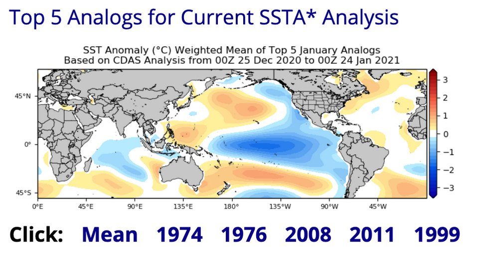
Obviously taken with a grain of salt, but a SSTA analog composite of 1974, 1976, 2008, 1999, and 2011 is about as high end as you can get when it comes to Nina springs.

1611526908365.png

This shows the actual correlation ranking of those. 1974/1976 seems tied at the front, 2008/2011 tied right behind. 1976/2008 were cool seasons that seemed to be very ridge happy. 1974/2011 both featured at least periods of sustained suppression, 2011 a bit more tan 1974.
 

andyhb

Member
Messages
1,083
Reaction score
2,936
Location
Norman, OK
12z EPS mean had an 80-90 kt 500 mb jet over the OV with that trough in early Feb, 276 hours out. That's pretty darn impressive.
 

andyhb

Member
Messages
1,083
Reaction score
2,936
Location
Norman, OK
That solution there would be too amplified and more of a QLCS threat, what you would look for is deamplification like what is happening with the current system favoring EML advection, diffuse forcing, and therefore a higher potential for discrete convection.

Still really far out to be looking at any one solution with any degree of scrutiny, however.
 

andyhb

Member
Messages
1,083
Reaction score
2,936
Location
Norman, OK
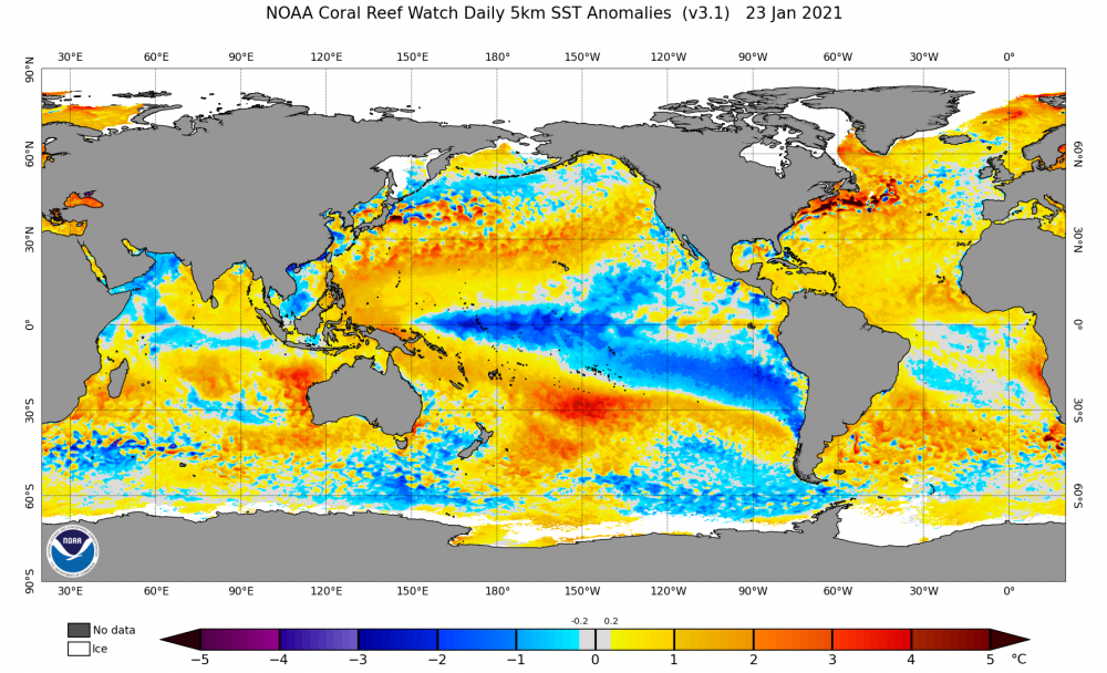
Posted this elsewhere, but I wanted to repost here to highlight a feature that I've noticed tonight upon analyzing some of the SSTA patterns with previous La Nina events.

image.thumb.png.e406ec788bb1a6ae94bcd37fdb044207.png

Did some skimming of SSTA data tonight and I'm intrigued by that warm pool centered at ~150˚W and 30˚S to the south of the cold SSTAs with the Nina. Based on looking into some previous analogs around this time, it seems like that strong meridional dipole is not present in years such as 2006, 2009, 2012, 2017, and 2018 (generally quieter severe seasons especially late season). It is more prevalent in several big Nina springs though, including 1974, 1976, and 2011.

It's probably to some degree why this CDAS-derived SSTA analog product from Tropical Tidbits is essentially grouping a who's who of Nina springs with a lot of tornadoes/severe weather, including some with very large outbreaks.

image.png.c5ce00b04be0e1951ca1df3b8f7669a2.png


You can see the SSTA dipole present in the Southern Hemisphere in the mean here.
 
Messages
2,833
Reaction score
4,557
Location
Madison, WI


Obviously taken with a grain of salt, but a SSTA analog composite of 1974, 1976, 2008, 1999, and 2011 is about as high end as you can get when it comes to Nina springs.

Interesting dichotomy between those and the total dud* analog set of 2006/09/12/18 etc. There really seems to be little room for a middle ground in Nina years. I wonder if you're onto something with that meridional SSTA dipole.

*2006/12 had some big events mid-April and earlier, but shut down by May especially in the Plains.
 

Fred Gossage

Member
Meteorologist
PerryW Project Supporter
Messages
596
Reaction score
2,096
Location
Florence, AL
1611687570028.png
Here is the latest look at the CDAS analogs from TropicalTidbits.com. 1974 has now pulled to the front of the list, instead of tying with 1976. 2011 has an equal correlation to 2008 but has pulled ahead of it.

1611687631596.png

Here is a look at the Euro weeklies going into the start of mid March. There is your screaming -PDO with a PDO configuration almost a carbon copy of 1974's, combined with a screaming +TNI. That also shows the southern Pacific dipole that Andy pointed out above. Not only was it not really present in those lesser years that Andy listed, but even in 2008, it was much more muted, and it was not present in 1999. This seems to be a calling card of the high-end years, and it also seems to be directly associated with a strongly positive TNI, as you'd expect, since it needs significantly cooler water in the western ENSO regions to form the cold half of the couplet.
 

Weatherphreak

Member
Messages
352
Reaction score
346
Location
Huntsville
I don’t know whether to be excited or scared. Watching the Cullman/Arab tornado pass just north of me was amazing but obviously you also had the tragic part of that and many other tornadoes that day.
 

Fred Gossage

Member
Meteorologist
PerryW Project Supporter
Messages
596
Reaction score
2,096
Location
Florence, AL
I don’t know whether to be excited or scared. Watching the Cullman/Arab tornado pass just north of me was amazing but obviously you also had the tragic part of that and many other tornadoes that day.
We know the pattern is there. We will be ready. We will get through whatever happens. It's ultimately up to an individual system to take full advantage of the background environment. Just because the pattern is even strikingly similar to some of these years with historic days doesn't automatically mean we will have a historic day this time. However, the historic days happen with this pattern for a reason. This pattern assembles the necessary ingredients to allow it. With the background state as it is, while it's not a guarantee, the door for it to be possible is more open this year than it is in others, by a great deal. Even though it's up to an individual storm system to take full advantage of these conditions and it's the smaller scale details we can't know in advance, the larger scale background state sets the limits for what the smaller scale is allowed to do. The mesoscale is informed by the synoptic setup of a storm. That synoptic storm is informed by the overall background state.
 
Back
Top