
A key to this event is, IF, the models are underestimating the speed of the dense arctic airmass, then totals will likely be higher. Models often struggle with the speed of cold air advection. Most places this will start as rain (washing away road treatments), but it should quickly transition to snow overnight Monday into Tuesday with temps dropping below freezing.
Navigation
Install the app
How to install the app on iOS
Follow along with the video below to see how to install our site as a web app on your home screen.
Note: This feature may not be available in some browsers.
More options
-
Welcome to TalkWeather! We see you lurking around TalkWeather! Take the extra step and join us today to view attachments, see less ads and maybe even join the discussion. CLICK TO JOIN TALKWEATHER
You are using an out of date browser. It may not display this or other websites correctly.
You should upgrade or use an alternative browser.
You should upgrade or use an alternative browser.
Winter WX January 29-30 Southeast Event
- Thread starter apocalyptic_pleasures
- Start date
X
Xenesthis
Guest
Is it me or does it have the cold air in place before the precipitation really begins?
it is very close...i think the precip shield is a little ahead.Is it me or does it have the cold air in place before the precipitation really begins?
X
Xenesthis
Guest
How do you feel about the southern middle TN area?it is very close...i think the precip shield is a little ahead.
1"-2" overallHow do you feel about the southern middle TN area?
X
Xenesthis
Guest
Ok so pretty similar everywhere for the most part.1"-2" overall
I think that part of the forecast is fairly easy because most of the precip will come below freezing but no convective parameters to enhance or robOk so pretty similar everywhere for the most part.
it looks like the NAM is bringing the precip even quicker
skelly
Member
it looks like the NAM is bringing the precip even quicker
In and out quicker or earlier increasing duration?
it slows down a bit as it comes in so overall no change. now has 3.7" for BhmIn and out quicker or earlier increasing duration?
Kory
Member
Looks like maybe a weak secondary low along the coast to enhance precip along the I-20/59 corridor.it slows down a bit as it comes in so overall no change. now has 3.7" for Bhm
northeastatlwthrguy
Member
wonderful, what does it show for ATL? many thanks
explain this lolwonderful, what does it show for ATL? many thanks

MattW
Member
- Messages
- 387
- Reaction score
- 379
- Location
- Decatur, GA
- HAM Callsign
- KG4GUF
- Special Affiliations
- SKYWARN® Volunteer
The GFS has been consistent with 1-2" for ATL...I'm guessing the NAM just hasn't caught up or there's just...something weird about it. Unless the NAM stays consistent through tomorrow with that weird gap (and one time that blob SE of Atlanta was showing 7"+), I'm not buying it yet.
yeah, I am not buying that either..but there is a trend for higher moisture across Alabama, I wouldn't be surprised if totals tick up a little bit more..or take the higher totals we have now and spread them over a larger area is probably more realistic.The GFS has been consistent with 1-2" for ATL...I'm guessing the NAM just hasn't caught up or there's just...something weird about it. Unless the NAM stays consistent through tomorrow with that weird gap (and one time that blob SE of Atlanta was showing 7"+), I'm not buying it yet.
northeastatlwthrguy
Member
Yes I think is accurate. This thing has some potential to over perform in my opinion. 1-2 inches widespread is a safe bet, but I think there will be more widespread pockets of 3-4
Bama Ravens
Member
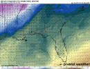
Great 00z GFS run for North and Central Alabama.
Bama Ravens
Member

skelly
Member
Wow. If this pans out and keeps trending this way could be one of the most significant snows/ winter storms in awhile for a lot of Alabama, Mississippi, Georgia...We’ll see soon I guess.
Bama Ravens
Member
Temps at noon on Tuesday.
