
Navigation
Install the app
How to install the app on iOS
Follow along with the video below to see how to install our site as a web app on your home screen.
Note: This feature may not be available in some browsers.
More options
-
Welcome to TalkWeather! We see you lurking around TalkWeather! Take the extra step and join us today to view attachments, see less ads and maybe even join the discussion. CLICK TO JOIN TALKWEATHER
You are using an out of date browser. It may not display this or other websites correctly.
You should upgrade or use an alternative browser.
You should upgrade or use an alternative browser.
Severe Weather Threat November 24-25, 2025
- Thread starter MichelleH
- Start date
This supports the idea of a upgrade to higher tornado chances for tommrow. 80% is relatively high although I think the 80% on the CIPS is a bit misplaced to where I think the higher risk area will setup.
AJS
Member
Oh you have got to be kidding me…
AJS
Member
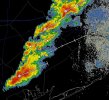
I’m not gonna lie, I don’t like the look of these storms to the SW of my area right now.
Oof, that's certainly a concerning solution
Mini-x Fan
Member
They seem to be taking shape quickly.
AJS
Member
Stay safe man. I don’t like the look of these storms already.They seem to be taking shape quickly.
WeathermanLeprechaun
Member
The kinematics aren't greatly impressive even then. Conditional tor threat here before LLJ ramp up then it could get spicy. This is all CB induced
AJS
Member
These storms are developing pretty quickly.
WeathermanLeprechaun
Member
These are likely the same storms depicted. SimRef is just a tool but discrete mode doesn't necessarily mean there is strong shear in place. Currently, all are elevated and in a 20 kt LLJ. That will increase however, and i would suspect these storms may become tornadic soon unless we continue seeing further bands of prefrontal development.
Attachments
Still pretty conditional, but amongst these kinds of setups, the ceiling is fairly high.This supports the idea of a upgrade to higher tornado chances for tommrow. 80% is relatively high although I think the 80% on the CIPS is a bit misplaced to where I think the higher risk area will setup.
RFD66
Member

WeathermanLeprechaun
Member
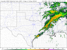
Your average 1am prefrontals in W MS! Been hinting at this sneaky, localised band as well but thermos are iffy. Tornado threat still there though
Regarding tmrw, still impressed with the prefrontal band that develops. Get a good bit of recovery + instability, with the strong low level shear and areas from W to E AL may very well see several tornadoes including a strong tornado threat at place too.
Regarding tmrw, still impressed with the prefrontal band that develops. Get a good bit of recovery + instability, with the strong low level shear and areas from W to E AL may very well see several tornadoes including a strong tornado threat at place too.
Attachments
zachary browm
Member
Looks Concerning...
zachary browm
Member
Oh No.Your average 1am prefrontals in W MS! Been hinting at this sneaky, localised band as well but thermos are iffy. Tornado threat still there though
Regarding tmrw, still impressed with the prefrontal band that develops. Get a good bit of recovery + instability, with the strong low level shear and areas from W to E AL may very well see several tornadoes including a strong tornado threat at place too.
WeathermanLeprechaun
Member
Welcome to the forum on a side note since you just joined on Friday. CWASP sometimes blows out of proportion but gives a good idea at where the risk will be. Tomorrow can be another one of those sneaky days to Dixie, and i feel it may very well be.Looks Concerning...
zachary browm
Member
I Got a Sneaky Suspicion That Tonight Will Overperform
AJS
Member
Shhh, the weather may hear you!!!I Got a Sneaky Suspicion That Tonight Will Overperform
zachary browm
Member
AlrightShhh, the weather may hear you!!!