
Storm near Grenada, MS is producing a lot of lightning. Might need to be watched for a possible tornado warning down the pipeline.
Navigation
Install the app
How to install the app on iOS
Follow along with the video below to see how to install our site as a web app on your home screen.
Note: This feature may not be available in some browsers.
More options
-
Welcome to TalkWeather! We see you lurking around TalkWeather! Take the extra step and join us today to view attachments, see less ads and maybe even join the discussion. CLICK TO JOIN TALKWEATHER
You are using an out of date browser. It may not display this or other websites correctly.
You should upgrade or use an alternative browser.
You should upgrade or use an alternative browser.
Severe Weather Threat November 24-25, 2025
- Thread starter MichelleH
- Start date
Also, has anyone else noticed how the radar thru RadarScope looks smoother or more raw looking? I can't figure out what they did.
Kds86z
Member
Kds86z
Member
Kds86z
Member
01z hrrr is pretty concerning for Alabama. Hrrr runs are leaning more to a spaced out supercellar environment tommrow.
Late night hot take, we see a small corridor of 10% risk for tornadoes in Alabama. Don't shoot the messenger lol.
Kds86z
Member
Late night hot take, we see a small corridor of 10% risk for tornadoes in Alabama. Don't shoot the messenger lol.
N
Not here anymore
Guest
See what I mean. This is off the HRRR 002Z run hour. I mean that either is a one run fluke or it tells another story in Limestone/Madison Co.and other North ALabama counties east of I-65 Will watch next hours run.

Last edited by a moderator:
Equus
Member
Hoping for no nighttime surprises this far north, tomorrow looks interesting but fingers crossed instability stays pretty marginal until the sun comes up. Warm front is still pretty far south but advection always seems to happen a bit faster than expected.
Often times, those localized maximums in SCP/STP parameters come from storms themselves and the micro-environment they produce. The larger regions of yellow values are what would be considered your "true" areal SCP/STP.See what I mean. This is off the HRRR 002Z run hour. I mean that either is a one run fluke or it tells another story in Limestone/Madison Co.and other North ALabama counties east of I-65 Will watch next hours run.
View attachment 48910
Jordan Hall has rapidly become my least favorite chaser this year, and it's not even close. Referring to running a red light as "clearing" it has to be the most self important cringe crap I've seen in a very long time.
He was probably scrambling to go fly his drone inside someone's private residence and then lecture the homeowners about copyright law.

Kds86z
Member
Equus
Member
Warm front lifting gradually on RAP; little showers south of Jackson certainly have instability to work with and I guess could grow, but curious to see how far north the leading edge of surface instability intersects with the heftier edge of the line. Lots of lightning and heavy rain either way... now to just avoid the scattered nighttime leading edge tornadoes we seem to always get stuck with

Kds86z
Member
joshoctober16
Member

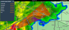
a lot of hook shapes are growing out of the bow , including a supercell north east of canton , a lot of weak rotation with most however canton supercell seems to now have strong rotation.
Kds86z
Member
Tornado possible tagView attachment 48916
a lot of hook shapes are growing out of the bow , including a supercell north east of canton , a lot of weak rotation with most however canton supercell seems to now have strong rotation.