
Got a question for you, what if we start seeing light flurries early tommorow morning in Birmingham, would that spell trouble for later? Indicating that the dry air isn't so dry lol? I get up at about 4am so that'll be around the time the nam pushes that finger of moisture into my arealooking at soundings, I feel ike the gfs is on to somehting....light snow epxanding northward to i 20 but only for an hour or two...no doubt some virga in the begining, but the mid layers have a lot more moisture than hrrr....which did a horrible job last event with precip type/dynamic cooling
Navigation
Install the app
How to install the app on iOS
Follow along with the video below to see how to install our site as a web app on your home screen.
Note: This feature may not be available in some browsers.
More options
-
Welcome to TalkWeather! We see you lurking around TalkWeather! Take the extra step and join us today to view attachments, see less ads and maybe even join the discussion. CLICK TO JOIN TALKWEATHER
You are using an out of date browser. It may not display this or other websites correctly.
You should upgrade or use an alternative browser.
You should upgrade or use an alternative browser.
Winter Threat January 18-24 do ya wanna build a snowman??
- Thread starter Havaheart66
- Start date
really depends on intensity...if its just light, not much impact The earlier it starts, the better chance we will have at least a dusting...Got a question for you, what if we start seeing light flurries early tommorow morning in Birmingham, would that spell trouble for later? Indicating that the dry air isn't so dry lol? I get up at about 4am so that'll be around the time the nam pushes that finger of moisture into my area
I'll make sure to post in the morning when I wake up, temps here are already 21 degrees, so whatever falls will stick cause it'll be colder than that tommorow morningreally depends on intensity...if its just light, not much impact The earlier it starts, the better chance we will have at least a dusting...
oh I doubt I will sleep past 5...wish i couldI'll make sure to post in the morning when I wake up, temps here are already 21 degrees, so whatever falls will stick cause it'll be colder than that tommorow morning
MikeP
Member
Looks to be moistening up a bit already into LA around Ft. Johnson. Donno if there's any ground truth yet.
Snow reports and mix reports all the way into baton rouge and middle LousiannaLooks to be moistening up a bit already into LA around Ft. Johnson. Donno if there's any ground truth yet.

@MikeP snow is actually ahead of schedule there when looking at the hrrr.
I'm starting to get a gut feeling about this event haha. Somebody is going to get a surprise or two
I'm starting to get a gut feeling about this event haha. Somebody is going to get a surprise or two
Last edited:
MikeP
Member
Yeah, that's what I thought as well. Looking at IR water vapor both mid and lower, looks like moisture is trying it's best back west....@MikeP snow is actually ahead of schedule there when looking at the hrrr.
I'm starting to get a weird gut feeling about this event haha. Somebody is going to get a surprise or two
James Spann posted:
From Jeremy DeHart with the Air Force Reserve Hurricane Hunters based at Kessler AFB on the Mississippi Coast…
“Look for potential swings in 00Z model output this evening with a @53rdWRS mission in progress over the Gulf. A second mission is also planned for 12Z.”
Dropsonde data from these missions will be incorporated into high resolution models; will be very interesting to see if there will be some changes in the projected intensity and path of the Gulf low (which in turn would impact weather in Alabama tomorrow).
Attachments
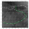
Uhhh yep that's ahead of scheduleSnow reports and mix reports all the way into baton rouge and middle Lousianna View attachment 33213
weunice
Member
I don't trust the report near BR. I think that one is a person testing the mPing app. But yes, happy to see some coming in now especially near Houston and into central LA.
There's snow all around it though, I wouldn't be surprised if it's true honestly. Could start seeing reports in New Orleans as wwellI don't trust the report near BR. I think that one is a person testing the mPing app. But yes, happy to see some coming in now especially near Houston and into central LA.


The Colonel
Member
(I’d suggest you look at mPING if you have any questions on ground truth)

Sleet just southwest of New Orleans now
wx_guy
Member
- Messages
- 1,237
- Reaction score
- 4,443
- Location
- United States
- HAM Callsign
- KO4ZGH
- Special Affiliations
- SKYWARN® Volunteer
- ARRL Member
This is great! We desperately need that data from the low over the Gulf. This will help lock in what's going to happen.James Spann posted:
From Jeremy DeHart with the Air Force Reserve Hurricane Hunters based at Kessler AFB on the Mississippi Coast…
“Look for potential swings in 00Z model output this evening with a @53rdWRS mission in progress over the Gulf. A second mission is also planned for 12Z.”
Dropsonde data from these missions will be incorporated into high resolution models; will be very interesting to see if there will be some changes in the projected intensity and path of the Gulf low (which in turn would impact weather in Alabama tomorrow).
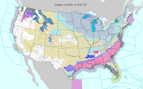
2014Not sure I can remember the last time the map's looked like this. A pretty incredible sight, no doubt. My thoughts go out to the bread and egg aisles in the Panhandle!
View attachment 33217
Attachments
stallions3peat
Member
Other than it being on a Tuesday what are the comparisons to Snowmaggedon?
MikeP
Member
Nice continuous band just south of Fort Worth. Rather interesting....