
Not sure yet, I thought a winter weather advisory would be good As a precautionDo you see I-20 having potential travel issues ?
Navigation
Install the app
How to install the app on iOS
Follow along with the video below to see how to install our site as a web app on your home screen.
Note: This feature may not be available in some browsers.
More options
-
Welcome to TalkWeather! We see you lurking around TalkWeather! Take the extra step and join us today to view attachments, see less ads and maybe even join the discussion. CLICK TO JOIN TALKWEATHER
You are using an out of date browser. It may not display this or other websites correctly.
You should upgrade or use an alternative browser.
You should upgrade or use an alternative browser.
Winter Threat January 18-24 do ya wanna build a snowman??
- Thread starter Havaheart66
- Start date
I saws that, snowmegodden was an open wave, i think it's less likely to dig as far south if its closed, or just go more east than southFrom BMX early morning discussion: "
Guidance remains conflicted as to whether this
low will remain closed off, or devolve into an open wave surface
trough as it moves east."
How would each solution affect snow totals?
If the system remains closed off, expect heavier, more localized snow totals with the potential for significant accumulations in the deformation zone. If it becomes an open wave, expect lighter and more widespread snow with less overall impact.From BMX early morning discussion: "
Guidance remains conflicted as to whether this
low will remain closed off, or devolve into an open wave surface
trough as it moves east."
How would each solution affect snow totals?
very true, a closed low is likely colder aloft, producing higher snowfall ratesIf the system remains closed off, expect heavier, more localized snow totals with the potential for significant accumulations in the deformation zone. If it becomes an open wave, expect lighter and more widespread snow with less overall impact.
Flurry
Member
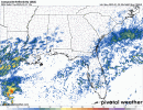
And so it begins…Precip has broken out in S. TX
Latest hrrr shows a finger extended out over into i20If we see an overperform on I 20, it's going to start to look like the last image....breaking out very early 6am, in time to help saturated low levels before vort max arrives.
12z gfs does the sameLatest hrrr shows a finger extended out over into i20
Newest hrrr does the same thing. By 4am very light precip over extending i20. 
Ars4ua
Member
When will we know about Low?very true, a closed low is likely colder aloft, producing higher snowfall rates
RAP's got vertical motion at 500mb that aligns with that as well. Potential for mesoscale banding. So definitely some potential for mischief.

What's mesoscale banding?RAP's got vertical motion at 500mb that aligns with that as well. Potential for mesoscale banding. So definitely some potential for mischief.
View attachment 33203
stallions3peat
Member
It's a band in the mesoscale. DuhWhat's mesoscale banding?
It would be certain localized areas of heavier precip that could get you a good amount in a short period of time and could also go over the same area to add to it.What's mesoscale banding?
Hey now get back to work Shane! Or you ain't getting any snow lol.It's a band in the mesoscale. Duh
cyelle21
Member
Sorry for all the questions, but what is the difference between the NBM versus SREF? Which one is better this close to the event?
warneagle
Member
we got our ~inch of snow yesterday and now the deep freeze is here for the rest of the week, joy
SREF is better for pinpointing smaller-scale features, the NBM general trends.Sorry for all the questions, but what is the difference between the NBM versus SREF? Which one is better this close to the event?