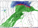
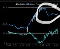
Well, it means the temperatures in the 850mb level (about 5k feet up, approx) at 3am get really cold, which would more likely support frozen precip. Again, it shows that happening at 3am. Then in the afternoon at 4pm (21Z), it shows that layer very warm again (warm nose) implying it will be all rain at that point.Seems like that puts central AL/Bham area in a pretty good spot then. Am I seeing that right?
Navigation
Install the app
How to install the app on iOS
Follow along with the video below to see how to install our site as a web app on your home screen.
Note: This feature may not be available in some browsers.
More options
-
Welcome to TalkWeather! We see you lurking around TalkWeather! Take the extra step and join us today to view attachments, see less ads and maybe even join the discussion. CLICK TO JOIN TALKWEATHER -
Current Tropical Systems Melissa
You are using an out of date browser. It may not display this or other websites correctly.
You should upgrade or use an alternative browser.
You should upgrade or use an alternative browser.
Winter threat: 1/9-12/ 25
- Thread starter DetectiveWX
- Start date
Still holding 33 at remlap 10pm.
Smokedevil
Member
Sleeting here just east of tupelo.
brianc33710
Member
38/12 Bham, 40/18 Tuscaloosa @Blountwolf if temps drop enough at the surface could that become freezing rain again by nightfall?
Nah, moisture will be gone. Here's 3pm:38/12 Bham, 40/18 Tuscaloosa @Blountwolf if temps drop enough at the surface could that become freezing rain again by nightfall?

sak
Member
Vertical
Member
So are we going to get 12 hours of frozen precip in central Alabama now? Am I understanding that correctly?
sak
Member
probably closer to 12 minutes to be honest.So are we going to get 12 hours of frozen precip in central Alabama now? Am I understanding that correctly?
If your along I20 or north it looks like you may have sleet or mix during the day until about midday. Most will probably come as freezing rain.So are we going to get 12 hours of frozen precip in central Alabama now? Am I understanding that correctly?
Vertical
Member
Thanks. No bueno!
Still 33 here in remlap at 11pm
sak
Member
Yes, for it to START as frozen about 3am. Snow, sleet - what that shows is the layer at 5000ft supporting that much better than it is now over North Central Alabama in general, yes. Won't mean much for our snow accumulation chances I'm afraid - this does look like it is going to change over to rain during the day, according to almost all the models at this point. By tomorrow afternoon, the models forecast there to be little or no snow depth left in central AL. GFS has a little left over, so there is some hope, but not much, IMO. I wish I could say otherwise, and I hope we all wake up to a surprise, but temper your expectations on this one I'm afraid.Seems like that puts central AL/Bham area in a pretty good spot then. Am I seeing that right?
Last edited:
sak
Member
10 miles SE of downtown bham.Where do you live at?
Here's hoping we get some big surprises, but if we get much if any that lasts, I'll be very surprised. Best case scenario for me would be it drop a few quick inches for a few hours to play in before it QUICKLY transitions to all (not freezing) rain and washes it away.
brianc33710
Member
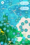
The temps aren't dropping at all. Haleyville has changed from 34/14 & light rain at 11 pm hourly to 32/17 & snow starting 11:15. That's some good news. But Bham is still 38. I really thought at least 35 by now given how low the dp is.
A stronger layer of warm air aloft can offset surface cooling. The low dewpoint would create cooling in heavy precipitation in to it, but the air aloft - the warm nose - is winning the temperature battle until the precipitation arrives.The temps aren't dropping at all. Haleyville has changed from 34/14 & light rain at 11 pm hourly to 32/17 & snow starting 11:15. That's some good news. But Bham is still 38. I really thought at least 35 by now given how low the dp is.
Now if we can get some really heavy bands into those low dewpoints all at once, it will cool the whole column and go over to snow. That report out of Haleyville is a good sign. You can see it happen in the reports - the rain into the low-dewpoint air cools the column and it switches over to snow:

Now not to Forecasted Convective Amplification Deficiency bubbles, but that may be an automated station making an assumption about what the precip type is, but it certainly shows evap cooling in progress under the heavier returns.

Now not to Forecasted Convective Amplification Deficiency bubbles, but that may be an automated station making an assumption about what the precip type is, but it certainly shows evap cooling in progress under the heavier returns.


