X
Xenesthis
Guest
You all need to keep in mind what Fred and Richard has to say.... Also I don’t see this fly making it into the ointmentI for one am glad to at least see a fly in the ointment.
Follow along with the video below to see how to install our site as a web app on your home screen.
Note: This feature may not be available in some browsers.
You all need to keep in mind what Fred and Richard has to say.... Also I don’t see this fly making it into the ointmentI for one am glad to at least see a fly in the ointment.
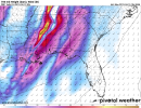
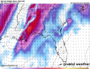
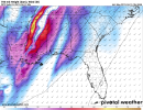
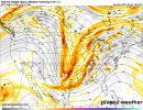
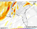
Everything I have seen or heard in the Birmingham market has been it could be a significant threat.Local news seems to think Thursdays risk is rather insignificant due to low instability
It would be really nice if for this event the local mets, the SPC, and NWS offices could all be on the same page.Local news seems to think Thursdays risk is rather insignificant due to low instability
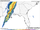
I agree!!It would be really nice if for this event the local mets, the SPC, and NWS offices could all be on the same page.
It would be, but the models aren’t perfect. There is a ton of human interpretation involved.It would be really nice if for this event the local mets, the SPC, and NWS offices could all be on the same page.