pritchlaw
Member
The wind is HOWLING out of the south in Hayden, Alabama.
Follow along with the video below to see how to install our site as a web app on your home screen.
Note: This feature may not be available in some browsers.

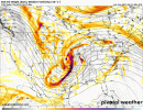
How are you currently feeling about this set up as you see it right now. Obviously things will get fine tuned as we get closer. I was just curious if your thoughts..the 0z euro has a surface low in the tenn valley Thurs evening, would love to know if there is much ensemble support on that idea
the 0z euro has a surface low in the tenn valley Thurs evening, would love to know if there is much ensemble support on that idea
thats actually not the primary slp am I correct...? And that slp over Tennessee valley on the euro would be a secondary slp?the 0z euro has a surface low in the tenn valley Thurs evening, would love to know if there is much ensemble support on that idea
correct and would really ramp up the low level shear...looking at that right now, I think it is just noise, but other runs I believe had a similar lookthats actually not the primary slp am I correct...? And that slp over Tennessee valley on the euro would be a secondary slp?
That's a concerning look. I don't like that at all.lots to be figured out at this point, but some of the models runs I have seen look very concerning. Assuming there isn't an issue with instability, I think the key is the 2nd vort max diving in. If it is slow enough it will cause the trough to become more broad based...opening the door for a large wide warm sector with plenty of expansive mid level shear....if there is low level shear too, in some ways, a classic April outbreak setup for the mid south/dixie...but again, there are still a lot of unknowns to be figured out yet.
Yes your not joking there... talking bout helping to back the winds ...correct and would really ramp up the low level shear...looking at that right now, I think it is just noise, but other runs I believe had a similar look
Fred, you are right on...we have seen plenty of severe events with the sfc low centered well away..there are several ways to get strong pressure falls and backing winds without the low being in your backyard.I will provide a word of caution preemptively in case this starts coming up in discussion in places:
Don't get too hung up on the surface low being pretty far to the north. Low-level winds are still backed way down in the warm sector, there are still significant surface pressure falls through the MS/AL/GA/TN portion of the warm sector, and the actual upper-level energy Thursday is more directly aimed here. To the thunderstorms, it still "feels" like the surface low is closer because of all that. They don't check the GFS, or Euro, to see what the surface low position is before they decide to rotate. We have had MANY outright violent tornado events over the decades here in Alabama with surface low positions a good bit north of what is considered that "classic" track from central Arkansas into Kentucky.
I concur entirely. I was alluding to that in prior posts. This feels like it could affect a lot of real estate and could be quite a significant eventI will provide a word of caution preemptively in case this starts coming up in discussion in places:
Don't get too hung up on the surface low being pretty far to the north. Low-level winds are still backed way down in the warm sector, there are still significant surface pressure falls through the MS/AL/GA/TN portion of the warm sector, and the actual upper-level energy Thursday is more directly aimed here. To the thunderstorms, it still "feels" like the surface low is closer because of all that. They don't check the GFS, or Euro, to see what the surface low position is before they decide to rotate. We have had MANY outright violent tornado events over the decades here in Alabama with surface low positions a good bit north of what is considered that "classic" track from central Arkansas into Kentucky.
.LONG TERM [Wednesday Night Through Monday]...
As multiple shortwaves superposition over the Southern Plains and
Lower Mississippi Valley, an anomalously deep longwave trough
will develop over the Deep South. This frontal system will be
stronger than this past weekends and will bring a high likelihood
of severe weather to the Southeast. Severe weather probabilities
based off of analog data are quite high across the Tri-State
region Thursday night, and SPC has steadily carried a Slight Risk
since this system appeared in their day 4-8 forecast. While the
exact timing, and placement of the highest threat for severe
weather is highly uncertain at this time, everyone should pay
close attention to the forecast over the next few days as the
chance of a severe weather `outbreak` across the Southeast is
increasing.

.gif")
Looking at the severe threat, confidence remains low on how
significant the threat will be on Thursday. It seems the main
limiting factor will be very poor lapse rates between 700 mb and 500
mb during the main window of concern, likely due to the fact that
the upper trough remains positively to neutrally tilted and well to
our west for much of the afternoon. With that said, however, in the
days leading up to the system, southerly flow will be fairly
persistent and as it strengthens, dewpoints will climb into the lower
60s. Despite some shower activity in the morning, there should be
enough breaks in the cloud cover and strong enough WAA for temps to
climb into the mid 70s by the afternoon. This should provide
sufficient low level lapse rates during the afternoon and early
evening hours. But again, if the lower mid level lapse rates pan
out, it will greatly limit the severe threat. So, I`m not overly
confident that we will see the needed instability for an organized
severe threat. With that said, however, the wind profiles are
impressive as the low level jet intensifies as it crosses the
Mississippi River. The GFS and ECWMF are in fairly good agreement
that 850 mb winds increase as high as 60kts late Thursday afternoon
as showers and thunderstorms move into the area. As this occurs,
there may be a narrow window of steeper lapse rates as the upper
trough tries to become negatively tilted and this would lend us some
moderate instability. Certainly not a slam dunk scenario, however
there is enough chance for severe weather that we will mention it in
the HWO Thursday afternoon and evening.