• Welcome to TalkWeather!
    We see you lurking around TalkWeather! Take the extra step and join us today to view attachments, see less ads and maybe even join the discussion.
    CLICK TO JOIN TALKWEATHER

Weather Banter

Equus

Member
Messages
3,290
Reaction score
3,368
Location
Jasper, AL
Special Affiliations
  1. SKYWARN® Volunteer
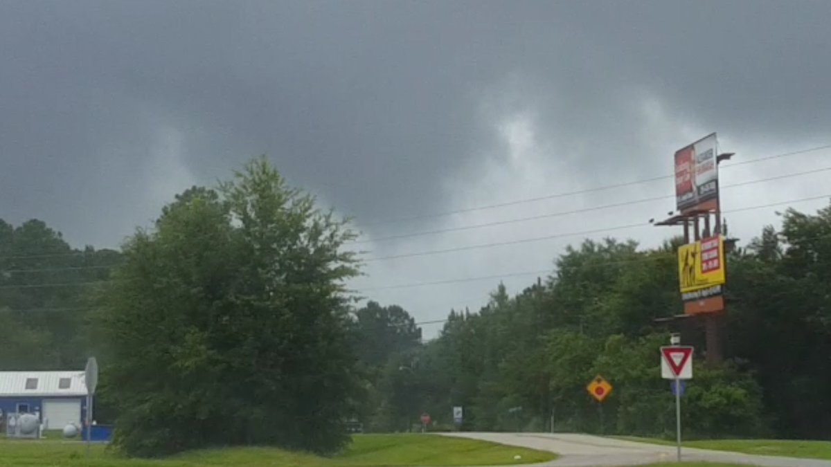
Two years ago today I caught my first tornado near Summerdale (Baldwin co) off Tropical Storm Cindy

dc76gx5wsaipedv.jpg
 

Equus

Member
Messages
3,290
Reaction score
3,368
Location
Jasper, AL
Special Affiliations
  1. SKYWARN® Volunteer
And one year from tomorrow (6/22/18) on the same day that an EF2 hit Cullman county, this probable brief totally unexpected tornado on the north side of a rotating shower at the end of my driveway. Snapped some tree branches down the road. Thought it was just scud but obsessively reviewing the video, a case could certainly be made. Never officially entered into tornado database though.

 
Last edited:

Equus

Member
Messages
3,290
Reaction score
3,368
Location
Jasper, AL
Special Affiliations
  1. SKYWARN® Volunteer
Anyone have archived soundings from the May tornado sequence? I'd collected observed soundings from the May outbreak sequence from the SPC page from the outbreak area from 5/17 to about 5/30 and I lost everything in a hard drive crash just after the last of that period fell off the SPC two week archive. Looking mainly for the days with significant/strong tornado activity and upstream.
 

Lori

Administrator
Staff member
Administrator
Moderator
Messages
1,035
Reaction score
653
Location
Vandiver, AL
Special Affiliations
  1. SKYWARN® Volunteer
 

bjdeming

Member
Sustaining Member
Messages
1,512
Reaction score
1,231
Location
Corvallis, Oregon
Flooding in India brings many surprises: reportedly, almost all of the nearby national park was underwater Friday. (? which is worse, this or fire ants)


Mike S

Administrator
Staff member
Administrator
Moderator
PerryW Project Supporter
Messages
1,991
Reaction score
1,115
Location
Meridianville, Al
Special Affiliations
  1. SKYWARN® Volunteer
I predict severe weather across north Alabama next week. KHTX is due to be offline for a few days.
 

JayF

Technical Administrator
Staff member
Administrator
Moderator
Sustaining Member
Technical Admin
Messages
1,624
Reaction score
878
Location
Hartselle, al
HAM Callsign
KB4JCS
I guess you need to watch where you sit during a thunderstorm. Good thing no one was hurt.


KoD

Moderator
Staff member
Moderator
PerryW Project Supporter
Messages
1,380
Reaction score
697
Location
Huntsville, AL
One of the worst allergy seasons ever! Year, after year after year after year....


JayF

Technical Administrator
Staff member
Administrator
Moderator
Sustaining Member
Technical Admin
Messages
1,624
Reaction score
878
Location
Hartselle, al
HAM Callsign
KB4JCS
I don't always agree with him, but he is funny. LOL and as predicted, next year will be the worst allergy season. LOL
 
  • Like
Reactions: KoD

WesL

"Bill, I'm talkin' imminent rueage"
Staff member
Administrator
Moderator
Sustaining Member
Messages
3,344
Reaction score
2,614
Location
Fayetteville, AR
Special Affiliations
  1. SKYWARN® Volunteer
I'm pretty late to the party here, but my girlfriend just showed me this today and I'm DYING, haha. I've been down to Arizona a few times and I have to say it seems pretty accurate.


This is and always will be one of my favorite clips. I sincerely hope this is something they show broadcast met students in school. Sometimes technology gets the best of you and all you can do is roll with the punches.
 

KoD

Moderator
Staff member
Moderator
PerryW Project Supporter
Messages
1,380
Reaction score
697
Location
Huntsville, AL
Very unsettling to hear this again. Limestone/Madison tornado emergency EAS from 4/28/2014
 

bjdeming

Member
Sustaining Member
Messages
1,512
Reaction score
1,231
Location
Corvallis, Oregon
Woof! We're not in bad shape here in Corvallis, where this system should just bring chilly rain and, if we're lucky, a T-storm, but they're predicting lowered snow levels in the Cascades this weekend and things look to be getting intense for the Rockies. So early in the season!

An anomalous upper level low pressure system dropping into the Northwest this afternoon will be responsible for the development of an early season and major to potentially historic winter storm across portions of the Northern Rockies this weekend. This storm will bring very heavy snowfall, high winds, blizzard conditions, and extreme impacts to travel. Western Montana is forecast to see the brunt of the snowfall, with as much as 1 to 3 feet (locally more) possible. This system will also usher in a very cold airmass, at least for September standards, with daytime highs 20 to 30+ degrees below normal. Many daily record low maximum temperature records are possible this weekend, especially across the northern Great Basin/Rockies, and California.

-- WPC

Wish I could send a little bit of the low Yukon-style temperatures to the Southeast right now!
 
Logo 468x120
Back
Top