• Welcome to TalkWeather!
    We see you lurking around TalkWeather! Take the extra step and join us today to view attachments, see less ads and maybe even join the discussion.
    CLICK TO JOIN TALKWEATHER
  • April 2024 Weather Video of the Month
    Post your nominations now!

Svr Wx threat March 24-26th 2024

Clancy

Member
Messages
3,017
Reaction score
5,636
Location
Macland, Georgia
Man if a decent warm sector meshed correctly with the kinematics it would be a eventful day. This type of ejection with a sub 1000mb low usually spells trouble for the southeast when you have a relatively good warm sector. All eyes on the placement and how deep the low is and the quality of the warm sector.
Considering the back-and-forth on models, esp. the GFS, regarding dews, definitely something to watch closely as the event nears. Moisture return will be key to the character of this event for the Deep South.
trend-gfs-2024032106-f135.sfctd-imp.conus.gif
 
Messages
2,890
Reaction score
4,779
Location
Madison, WI
12Z NAM would certainly support a severe/tornado threat in a narrow arc across eastern Iowa Monday afternoon. Those hodographs and 3CAPE are something else, if not for the antecedent Gulf drying, I really think we'd be staring down the barrel of another significant late March outbreak. The one thing I will say is that the surface low appears to be weakening with time on Monday; whereas last year March 31 it was deepening or at least holding steady. That might have mitigated the overall threat some in any case, but even so that's a pretty impressive profile despite the paltry on their face T/Td values. You only have to go back one more year (and in the very same state no less) to see what can happen when a setup like that overperforms.
 

Attachments

  • nam_2024032212_081_42.42--91.98.png
    nam_2024032212_081_42.42--91.98.png
    239.5 KB · Views: 0

JBishopwx

Member
Sustaining Member
Messages
938
Reaction score
2,133
Location
Ackerman, MS
Special Affiliations
  1. SKYWARN® Volunteer
Jackson's AFD:
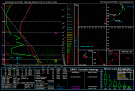
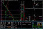
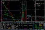
The main concern in the extended term continues to be the potential
for severe storms, mainly Monday night, as a potent shortwave ejects
across the southern plains. In response, low level moisture
increases, mainly south of I-20, as denoted by dewpoints in the 63
to 68 degree range. Strong deep shear around 70 kts, and strong low
level directional shear will result in long curved hodographs.
Surface winds will be backed ahead of a prefrontal trough beneath a
favorable 572 to 576 dm 500mb height zone. Storms in this zone,
areas south of I-20, especially along HWY 49 and I-59, will be
capable of producing tornadoes and damaging wind gusts, mostly in
the early morning hours Monday night into Tuesday morning. A forced
squall line will follow with the passage of the prefrontal trough,
which will carry a damaging wind threat and possibly a QLCS tornado
threat before clearing the area by mid Tuesday morning. A slight
risk is currently highlighted in the HWO graphic, but with
increasing confidence, an upgrade to enhanced is likely for the day
2 time frame.
 
Messages
2,890
Reaction score
4,779
Location
Madison, WI
Incoming 00Z NAM appears to have that secondary surface low (998 mb) over Arkansas which really backs the winds and ramps up the low-level shear over Louisiana/southern Arkansas into southwestern Mississippi Monday afternoon/evening. Meanwhile, it appears to be downtrending the already questionable moisture on the main surface low in Iowa, so I'm less optimistic about chase prospects up this way; between that and the fact I realized I do have to work on Monday, after all.
 

Attachments

  • nam_2024032400_045_31.63--93.29.png
    nam_2024032400_045_31.63--93.29.png
    238.1 KB · Views: 0
  • nam_2024032400_045_33.24--91.97.png
    nam_2024032400_045_33.24--91.97.png
    239.5 KB · Views: 0

Taylor Campbell

Moderator
Moderator
PerryW Project Supporter
Messages
2,138
Reaction score
2,242
Location
Wedowee, AL
Special Affiliations
  1. SKYWARN® Volunteer
Finally able to log back into Talkweather. My cloud storage got full and prevented the delivery of the two factor authentication emails.

The well developed low-level jet of 50+knts combined with the nose of 800-1000 SBCAPE across eastern LA/ SW MS in the delta Monday afternoon/evening has me concerned. I think a strong tornado threat materilizes in this region.
 

Taylor Campbell

Moderator
Moderator
PerryW Project Supporter
Messages
2,138
Reaction score
2,242
Location
Wedowee, AL
Special Affiliations
  1. SKYWARN® Volunteer
This assessment for best tornado potential doesn't look too off.

severe_ml_day2_all_gefso_032612.png
 

Taylor Campbell

Moderator
Moderator
PerryW Project Supporter
Messages
2,138
Reaction score
2,242
Location
Wedowee, AL
Special Affiliations
  1. SKYWARN® Volunteer
I hope the Rolling Fork area doesn't take it to the chin again. They are at risk.
 

Taylor Campbell

Moderator
Moderator
PerryW Project Supporter
Messages
2,138
Reaction score
2,242
Location
Wedowee, AL
Special Affiliations
  1. SKYWARN® Volunteer
Gleason mentioned in the Day 3 and also in the new Day 2 the possibility of greater probabilities in SPC outlooks if pre-frontal supercells become more apparent.

The 3KM NAM and the HRRR are both in agreement that storms will utilize the shear with updraft helicity streaks.
 
Last edited:
Back
Top