• Welcome to TalkWeather!
    We see you lurking around TalkWeather! Take the extra step and join us today to view attachments, see less ads and maybe even join the discussion.
    CLICK TO JOIN TALKWEATHER

Significant Tornado Events

Various homes swept away by the Hackleburg tornado

Cornelius Dr, Phil Campbell
Hackleburg-EF5-foundations.JPG
Hackleburg-EF5-damage-cornelius-dr.JPG

Woodard Rd, Phil Campbell
Hackleburg-EF5-damage-windrowing.JPG

near the Oak Grove cemetery (including a terrible low resolution ground level photo. Unfortunately the only ground level view of the home I could find)
Hackleburg-EF5-oak-grove.JPG
Hackleburg-EF5-damage-oak-grove.JPG
 
Follow up post about the NE/MO/IA violent tornadoes from the March 23, 1913 outbreak.

Omaha NE F4:
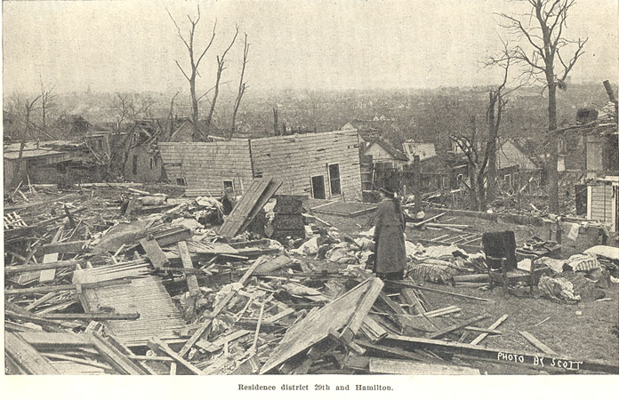
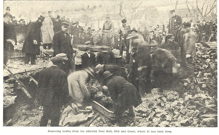
This tornado was actually likely the weakest out of all the F4s from this event though it was by far the deadliest. This wedge tornado formed SW of the Omaha area and moved through Ralston. In this town, multiple homes were leveled and a large steel safe was reportedly carried 300 ft. The storm then cut a devastating swath through northern and western Omaha. 600 homes (a lot of these were not well-built) were destroyed and several were leveled or swept away, especially near Bemis Park. A pool hall collapsed killing around a dozen people, brick business buildings were severely damaged, and trees were stripped of branches. The tornado then crossed the Missouri River into Iowa. In Iowa, a farmhouse near Beebeetown was leveled killing two children.
content

0.png

0.png

0.png

1913hamiltonresdist.jpg

1913idlewildpoolhall.jpg


Flag Springs MO F4:
An intense tornado would touch down SW of Savannah and move to east of Albany. The tornado likely first produced violent damage near Flag Springs where a house was swept away with the debris pile being deposited 50-60 ft away. Two people were killed here. The storm likely would reach maximum intensity north of King City where an entire farm was completely swept away with "all the contents cleaned from the premises, not leaving apparel or other household goods." Reportedly some of the foundation of the farmhouse was destroyed. The "Greenwall Ford" bridge over a river was destroyed and hurled into the riverbed, with one of the approaches being ripped up. All along the path grass and shrubbery were beaten down.

Council Bluffs IA F4:
This event was the 2nd deadliest tornado of the outbreak and the most poorly documented of the F4s due to it being overshadowed by the Omaha tornado just across the river. It touched down south of Bellvue and crossed the river into Iowa. It devastated small settlements and neighborhoods near Lake Manawa, sweeping away and leveling dozens of small homes. Next, the tornado churned its way through extreme southern Council Bluffs possibly at maximum intensity. A brick farmhouse in the area was reportedly swept away. A group of homes at/along South Ave and White Pole Road were virtually leveled. Multiple homes were completely swept away with only the brick foundations remaining and debris was strewn up to a quarter-mile from these homes. Bits of boards with "sharp cutting edges" were scattered everywhere along with heavier pieces of timber. Standing trees were plastered with mud and "there was scarcely a place where the bark had not been torn off." Clay banks were pitted with "millions of small holes" from debris impacts and 6-inch telephone poles were broken into "stovewood lengths." 17 people died in this part of the path. The tornado then moved through rural areas of Pottawattamie, Harrison, and Shelby Counties, killing 8 other people.

Yutan NE F4:
This major event began 1 mile SE of Mead and rapidly intensified, sweeping away a farm before moving through and devastating the town of Yutan. Very intense damage occurred in this town as a 125-foot high metal water tower collapsed, several homes/buildings in town were swept away including "the finest residence" which had "nothing but the foundation left intact," a cement sidewalk was "curved out of line," and trees were debarked "as smoothly as could be done with a knife." 17 people were killed in Yutan, half of which were children. The tornado continued into northwestern Douglas County still producing violent damage as multiple farms were leveled. Then it moved into Washington County where more violent damage was done as 4 farms were swept away and a school was obliterated with debris being scattered over a 30-acre area. 3 people died in rural areas of Nebraska. The tornado then crossed into Iowa with lesser intensity. Farmhouses in Harrison County, IA were reportedly "blown into splinters" and two people were killed near Logan. A photograph from Yutan was found 81 miles away in Iowa and reportedly a trunk was from town was carried across the Iowa border (>25 miles).
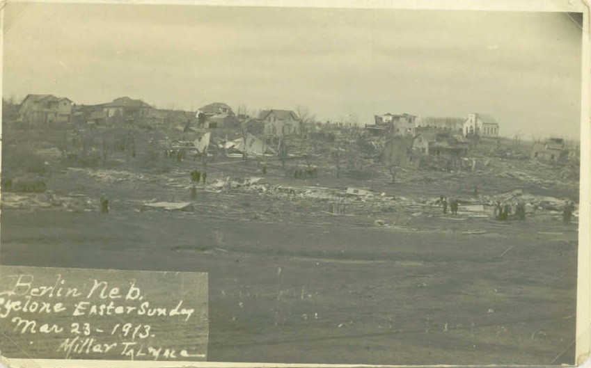
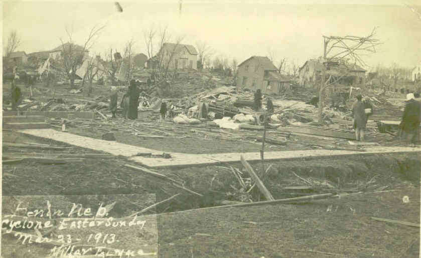
s-l400.jpg

0.png


Berlin NE F4:
This massive and violent tornado touched down 4 miles south of Douglas and began to cut a devastating swath through the countryside. Farm after farm was leveled with 3 farms being completely swept away north of Syracuse. The tornado then made a direct hit on the town of Berlin (now Otoe), virtually leveling a large area of the town. Multiple homes were swept away, large trees had bark stripped off "more easily than could be done by hand," the ground was apparently scoured as "it had the appearance of being scoured as much as if a swift stream of water had passed over," and one body was carried a quarter-mile. 12 people were killed in or near Berlin. The tornado continued its devastation, sweeping away 2 farms in Cass County before crossing the river into Mills County Iowa. In Mills County, 10 farms were destroyed with one being completely swept away. The tornado later dissipated east of Macedonia. 5 people were killed in Iowa while at least one was killed in rural areas of Nebraska.
58d153e95af49.image.jpg

58d153ed7df25.image.jpg

0.png

0.png
0.png

berlin-8.jpg

berlin-10.jpg

berlin-11.jpg

berlin-12.jpg

cyclone6.jpg

cyclone1.jpg


This outbreak was a high-end event and unprecedented in human impact-wise for the area. I believe that the Yutan and Berlin tornadoes are F5 candidates.

Interesting that the Omaha, NE and Council Bluffs, Iowa tornado were 2 separate events; I thought they were the same tornado as Council Bluffs is literally right across the Missouri River from Omaha. Also, the 1913 Omaha tornado MAY have been an F5, but all the damage photographs could reflect clean up efforts, so Grazulis assigned an F4 rating.
 
i just found another techincally but not official 200mph ef4 tornado. its the granbury texas tornado from may 15 2013. on the dat survey for it there's two homes that have the 200mph wind estimation on them. idk how many know about this.
 
I did a deep dive into the 1965 Palm Sunday tornado outbreak and looked through Fujita’s papers, Storm Data, and newspapers, then plotted every tornado that I could find. Once it was done, the total number of tornadoes I got was ~55 tornadoes. Probably some brief touchdowns in rural areas were missed but even if every single tornado was properly counted, I don’t think the number of tornadoes would exceed 80. Still though the violence of the outbreak was truly extreme with 19 violent tornadoes, at least two of which were F5s.
1965.jpg
 
Last edited:
This does make a fair amount of sense since the ridiculous shear and likely good amount of dry air aloft from that day would probably discourage a lot of updrafts from full developing via entrainment, but the ones that do go absolutely bonkers and produce multiple strong/violent tornadoes.

The shear/hodographs were slightly different in character to those on 4/27/2011 or 4/3/1974, longer given the extremely strong mid level winds and likely a bit straighter.

I've always been rather fascinated by this event since it is one of few (if not the only) springtime upper Midwest regional tornado outbreaks that also affected southern Wisconsin in addition to IA, IL, IN. It's actually pretty unusual to get a long-track, cyclic tornadic supercell that forms in Iowa and continues east/northeast, sustaining in that storm mode well into Wisconsin. Usually they dissipate or have lined out by the time they reach the Mississippi River.

The spatial distribution is rather interesting as well, with that storm relatively out by itself to the west and then the concentrated cluster of tornadic violence across IN/OH/southern lower MI. I'm guessing the IA/IL/WI activity formed and moved just out ahead of the triple point; and the main IN/MI/OH storms formed ahead of some sort of prefrontal trough or a rare appearance of an upper Midwest/Great Lakes dryline?
 
Radar imagery from the 1965 Palm Sunday outbreak.
View attachment 12568

I have to imagine that modern NEXRAD imagery from northern Indiana/southern Lower MI at the height of the event would have looked similar to KBMX or KGWX at the height of 4/27/11...just classic tornadic supercells everywhere, so much so that you think "No way they aren't destructively interfering with one another"...but they aren't.
 
Last edited:
Various homes swept away by the Hackleburg tornado

Cornelius Dr, Phil Campbell
View attachment 12552
View attachment 12553

Woodard Rd, Phil Campbell
View attachment 12554

near the Oak Grove cemetery (including a terrible low resolution ground level photo. Unfortunately the only ground level view of the home I could find)
View attachment 12555
View attachment 12556
I think TornadoTalk's article on Hackleburg has a high resolution photo of this home; unfortunately it's behind a paywall.
 
Anybody heard from locomusic01? Have been looking forward to his 1985 outbreak article for a while but he seems to have kinda dropped off recently. Hope all is well.
I'm alive! Had a death in the family and been absolutely swamped w/work so I haven't been able to make much progress lately. I've got like 21 or 22 of the 28 sections either finished or nearly so, but research has been maddeningly slow on a few tornadoes, and it's super time-consuming trying to chase people around when they say they have info/stories/photos but then don't get back to you.

Anyway, I expected to be done a long time ago but I underestimated the scale of the project. It's literally ended up the length of a short novel (~43,000 words so far). To be honest, I can't imagine many people even want to read something that long. I'll probably format it so that people have the choice of reading the whole thing or just jumping to whatever tornado(es) they wanna check out.

At this point, I figure I might as well aim for posting it on the anniversary since it's already taken so long.
 
@locomusic01,
Oh, one final thing while I'm thinking about Moshannon. I did find someone who said her grandparents had taken pictures of the tornado itself, which (if true) is the first I've heard of any such photos. She apparently has them but she hasn't sent them yet. I'm not getting all that excited unless/until I see them, but it's at least an intriguing possibility.
Did this end up bearing any fruit?
EDIT: And for that matter did you end up finding any Tionesta and Kane photos?
 

Attachments

  • smithville-ef5-tornado-damage-water-tower.png
    smithville-ef5-tornado-damage-water-tower.png
    604.5 KB · Views: 0
Last edited:
Here's a question: what is the longest known waterspout track on record? Most waterspouts documented in the U.S. (Florida Keys area specifically) are basically landspouts over water that are mostly stationary and don't do much damage. So, I'm wondering of any notable instances of a tornado that tracked over water for more than a couple miles offshore; the Temperance, MI tornado of 1953 left the shore and traveled across Lake Erie for most of its path but are there any reliable estimates on how long before it dissipated? Or is that impossible to answer?
 
Last edited:
Back
Top