
Navigation
Install the app
How to install the app on iOS
Follow along with the video below to see how to install our site as a web app on your home screen.
Note: This feature may not be available in some browsers.
More options
-
Welcome to TalkWeather! We see you lurking around TalkWeather! Take the extra step and join us today to view attachments, see less ads and maybe even join the discussion. CLICK TO JOIN TALKWEATHER
You are using an out of date browser. It may not display this or other websites correctly.
You should upgrade or use an alternative browser.
You should upgrade or use an alternative browser.
Significant Tornado Events
- Thread starter locomusic01
- Start date
Something newly discovered founding about Chapman's railway damage, nothing spectacularly new anyway.
I recheck this railway damage photo today and found It had been shoto from north to south, rather than south to north that I used to thought, which means the railway was distorted opposite to the direction of the tornado. I always thought that tornado pushed the railway forward this place but It seems that I was wrong. So If these conclusion are right, how the hell It can be done? There was simply no debris west of the railway or right side of the second pic so no way debris hitting theory.
The only guess here was tornado sucked the railway towards the tornado when It went really close due to pressure gradient, which was more ridiculous to think than the previous idea of tornado pushed the railway forward or maybe.....Ok, to be honest, I literally have no idea how the hell It can be done!
Last edited:
Juliett Bravo Kilo
Member
Perhaps intense inflow or suction vortices on the edge of the tornado?Something newly discovered founding about Chapman's railway damage, nothing spectacularly new anyway.
I recheck this railway damage photo today and found It had been shoto from north to south, rather than south to north that I used to thought, which means the railway was distorted opposite to the direction of the tornado. I always thought that tornado pushed the railway forward this place but It seems that I was wrong. So If these conclusion are right, how the hell It can be done? There was simply no debris west of the railway or right side of the second pic so no way debris hitting theory.
The only guess here was tornado sucked the railway towards the tornado when It went really close due to pressure gradient, which was more ridiculous to think than the previous idea of tornado pushed the railway forward or maybe.....Ok, to be honest, I literally have no idea how the hell It can be done!
View attachment 10765View attachment 10766View attachment 10767
MNTornadoGuy
Member
Ground scouring from the 2018 Tescott tornado


TH2002
Member
- Messages
- 4,973
- Reaction score
- 11,113
- Location
- California, United States
- Special Affiliations
- SKYWARN® Volunteer
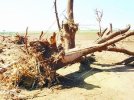
I always had a feeling Tescott was stronger than EF3. I know it is difficult to rate tornadoes that don't hit much, but this seems like confirmation to me it was capable of causing violent damage.Ground scouring from the 2018 Tescott tornado
On another note, it is interesting how like Lawrenceburg '98 and Cordova '11 Tescott seems to have caused its ground scouring in "bursts" of intensity rather than one continuous path. It is quite bizzare:


Incredible scouring there from Tescott, KS. I think we all had a hunch that it was stronger than EF3, and the similarities to Lawrenceburg, TN and Cordova, AL are undeniable. May I ask where you found them? I’d love to read whatever study or paper they were associated with (if they were).
What is the red arrow pointing out in the third photo?Ground scouring from the 2018 Tescott tornado
MNTornadoGuy
Member
Incredible scouring there from Tescott, KS. I think we all had a hunch that it was stronger than EF3, and the similarities to Lawrenceburg, TN and Cordova, AL are undeniable. May I ask where you found them? I’d love to read whatever study or paper they were associated with (if they were).
The arrow is pointing to a white marker for reference. Also the gouges were 6-10 cm deep.What is the red arrow pointing out in the third photo?
https://cdn.discordapp.com/attachme..._Track_Using_Unpiloted_Aerial_Systems_UAS.pdf
Shakespeare 2016
Member
I would rate that ground scouring as high-end EF4!What is the red arrow pointing out in the third photo?
- Thread starter
- #5,630
locomusic01
Member
Occasionally with multivortex tornadoes you can see little visible eruptions of dirt that seem to correspond with this sort of patchy scouring. There are several videos that show it pretty clearly (although my brain's toast and I can't think of any at the moment) and I've heard descriptions of the same sort of phenomenon with a few different tornadoes (Stecker, OK 5/3/99, Saegertown, PA & Albion, PA 5/31/85 and Sheridan, IN 4/11/65 come to mind). I'm very much not an expert in fluid dynamics, but this kind of thing seems pretty much in keeping with the papers I've read on the mechanics of vortex breakdown/suction vortices. It's pretty damn cool.On another note, it is interesting how like Lawrenceburg '98 and Cordova '11 Tescott seems to have caused its ground scouring in "bursts" of intensity rather than one continuous path. It is quite bizzare:
- Thread starter
- #5,631
locomusic01
Member
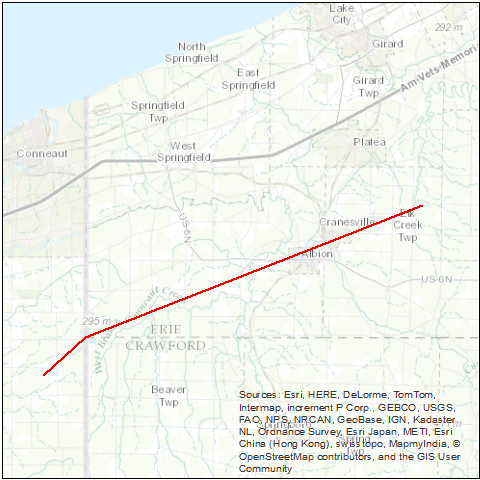
So here's something neat. I talked to a guy who was driving north on Rt. 18 toward Albion when he saw the tornado approaching from the southwest. He stopped at the crest of a hill overlooking town and had a great view of the whole event as it unfolded. He said that the tornado was pretty large and seemed to be bookin' along sort of toward the east or east-northeast when it suddenly slowed down dramatically, quickly shrank in size, did a little loop to the north and then continued on a curving path into town. "It stopped and wobbled around like a drunk for a minute" is how he put it.
Well, turns out you can sort of see where it happened in some of the aerial shots (the tree damage pattern just below center):

It's also pretty amazing how quickly the path narrowed. A little over half a mile to the southeast of here (toward the bottom left) is where the demolished farms were that I posted previously. The tornado was a quarter-mile wide there and more like half a mile wide a bit before that, but as you can see it shrinks to ~200 yards after the little loop/wobble/whatever you wanna call it. Eventually it ended up expanding to a quarter-mile again near Cranesville.
It almost looks like it was starting to occlude but then it just sort of.. kept on going lol
Well, turns out you can sort of see where it happened in some of the aerial shots (the tree damage pattern just below center):
It's also pretty amazing how quickly the path narrowed. A little over half a mile to the southeast of here (toward the bottom left) is where the demolished farms were that I posted previously. The tornado was a quarter-mile wide there and more like half a mile wide a bit before that, but as you can see it shrinks to ~200 yards after the little loop/wobble/whatever you wanna call it. Eventually it ended up expanding to a quarter-mile again near Cranesville.
It almost looks like it was starting to occlude but then it just sort of.. kept on going lol
Shakespeare 2016
Member
Which tornado was this?So here's something neat. I talked to a guy who was driving north on Rt. 18 toward Albion when he saw the tornado approaching from the southwest. He stopped at the crest of a hill overlooking town and had a great view of the whole event as it unfolded. He said that the tornado was pretty large and seemed to be bookin' along sort of toward the east or east-northeast when it suddenly slowed down dramatically, quickly shrank in size, did a little loop to the north and then continued on a curving path into town. "It stopped and wobbled around like a drunk for a minute" is how he put it.
Well, turns out you can sort of see where it happened in some of the aerial shots (the tree damage pattern just below center):
It's also pretty amazing how quickly the path narrowed. A little over half a mile to the southeast of here (toward the bottom left) is where the demolished farms were that I posted previously. The tornado was a quarter-mile wide there and more like half a mile wide a bit before that, but as you can see it shrinks to ~200 yards after the little loop/wobble/whatever you wanna call it. Eventually it ended up expanding to a quarter-mile again near Cranesville.
It almost looks like it was starting to occlude but then it just sort of.. kept on going lol
- Thread starter
- #5,633
locomusic01
Member
The 5/31/85 Albion, PA F4.Which tornado was this?
- Thread starter
- #5,634
locomusic01
Member
Also, I think my Albion track is probably finalized now. It's.. slightly different from the official path lol
Also also, from a distance it looks like somebody just got carried away with the smudge tool in Photoshop straight through the middle of town.

Also also, from a distance it looks like somebody just got carried away with the smudge tool in Photoshop straight through the middle of town.
Last edited:
CheeselandSkies
Member
So here's something neat. I talked to a guy who was driving north on Rt. 18 toward Albion when he saw the tornado approaching from the southwest. He stopped at the crest of a hill overlooking town and had a great view of the whole event as it unfolded. He said that the tornado was pretty large and seemed to be bookin' along sort of toward the east or east-northeast when it suddenly slowed down dramatically, quickly shrank in size, did a little loop to the north and then continued on a curving path into town. "It stopped and wobbled around like a drunk for a minute" is how he put it.
Well, turns out you can sort of see where it happened in some of the aerial shots (the tree damage pattern just below center):
It's also pretty amazing how quickly the path narrowed. A little over half a mile to the southeast of here (toward the bottom left) is where the demolished farms were that I posted previously. The tornado was a quarter-mile wide there and more like half a mile wide a bit before that, but as you can see it shrinks to ~200 yards after the little loop/wobble/whatever you wanna call it. Eventually it ended up expanding to a quarter-mile again near Cranesville.
It almost looks like it was starting to occlude but then it just sort of.. kept on going lol
Sounds kind of like what the afternoon Cordova tornado of 4/27 did as it approached Corridor X (now I-22) and the town proper. When on-air with ABC 33/40, Tim Coleman and Brian Peters described some erratic movement along with rapid shrinking and re-expanding. The reflectivity debris signature, which had been just as impressive as the Tuscaloosa-Birmingham one would eventually be over northern Tuscaloosa County and southeastern Fayette County (despite only EF1-EF2 damage being noted here, as it missed most towns and substantial structures until Cordova proper, and wouldn't actually be rated EF4 until after Cordova) also appeared to weaken briefly during this time.
Juliett Bravo Kilo
Member
Bridge Creek-Moore 1999 did something similar; it rapidly weakened to F2 then within a mile or so quickly regained F4 intensity and managed to keep on going.Sounds kind of like what the afternoon Cordova tornado of 4/27 did as it approached Corridor X (now I-22) and the town proper. When on-air with ABC 33/40, Tim Coleman and Brian Peters described some erratic movement along with rapid shrinking and re-expanding. The reflectivity debris signature, which had been just as impressive as the Tuscaloosa-Birmingham one would eventually be over northern Tuscaloosa County and southeastern Fayette County (despite only EF1-EF2 damage being noted here, as it missed most towns and substantial structures until Cordova proper, and wouldn't actually be rated EF4 until after Cordova) also appeared to weaken briefly during this time.
- Thread starter
- #5,637
locomusic01
Member
Yeah, kinda similar. Just north of Newcastle it weakened/shrank and sort of recurved while crossing the Canadian River before very rapidly exploding into an F5 again.Bridge Creek-Moore 1999 did something similar; it rapidly weakened to F2 then within a mile or so quickly regained F4 intensity and managed to keep on going.
May 3, 1999 - Bridge Creek-Moore, OK F5 - Google My Maps
May 3, 1999 - Bridge Creek-Moore, OK F5
 www.google.com
Robinson lee
Member
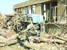
Speaking of the strong tornado in 2005, I think the tornado in Chaoyang, China has been completely ignored. Tornadoes caused impressive tree peeling and wind boating. Among the tornadoes I know about China, this kind of wind boat can only be compared with the Funing tornado in 2016. The tornado also destroyed an agricultural truck and threw it nearly 200 meters, causing a large number of houses to collapse. It is incredible how many violent tornadoes have been buried in history
Attachments
MNTornadoGuy
Member
- Thread starter
- #5,640
locomusic01
Member
This is kind of a weird topic, but I have a certain morbid fascination with the bizarre, almost inexplicable ways that some people die in tornadoes. This weekend I was talking to the granddaughter of the Albion-area woman who was killed in the car I posted photos of the other day. Since she lived in a trailer, the woman's daughter had picked her up and was planning to try and outrun the storm. For some reason, after she got her in the car, she ran back inside to grab a flashlight. It probably only took 30 seconds, but it was long enough - the daughter got back to the car and tried to take off just as the tornado swallowed them up. She was badly hurt but the steering wheel held her in place; her mother was sucked out of the car, thrown into a ditch and killed.
A woman near Cooperstown was killed when she and her husband were running to a cellar out in the yard. She was apparently worried they wouldn't have a bathroom if the house got destroyed, so she told her husband to go ahead while she went back to use the bathroom. Her husband survived unharmed. A similar scene played out near Tionesta, except the wife had gone back to make sure she'd turned the oven off. An Amish man was killed in Atlantic as he sat in his favorite spot on his porch, sipping lemonade and stubbornly refusing to take shelter even as his family begged him to join them in the basement. A man was killed by the Bridge Creek-Moore tornado because he'd just gotten one of those huge mechanic tool sets w/the cart and whatnot and.. I guess thought he was going to protect it somehow?
Those deaths are no less tragic than any others, of course, but it's oddly fascinating to see the strange reasons people end up meeting their fate.