• Welcome to TalkWeather!
    We see you lurking around TalkWeather! Take the extra step and join us today to view attachments, see less ads and maybe even join the discussion.
    CLICK TO JOIN TALKWEATHER

locomusic01

Member
Messages
1,350
Reaction score
3,758
Location
Pennsylvania
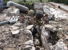
The Alma, ON F3 is another 5/31/85 tornado that allegedly caused substantial ground scouring. I'd never been able to find any photos to confirm it (finding photos in general hasn't been easy), but apparently that's what's depicted in the foreground here. Really no way to tell since it's in black and white, unfortunately:

GfUVUVw.jpg


This is pretty close to where some of the worst structural damage occurred, so if there was any scouring, it'd probably be here. A few hundred yards from this spot, the tornado leveled a large building that served as an office for a lakeside resort:

jpaJEu9.jpg


I do have some color photos, but none from this specific area. The closest one to this spot (a mile or so away) only shows a closeup of some small trees snapped off low to the ground:

KLLGRaO.jpg
 
Messages
2,157
Reaction score
2,712
Location
Missouri
I'm actually not sure if Fujita ever surveyed it tbh. He obviously was still working at that point, but the official surveys were conducted by Greg Forbes, Duane Stiegler and Jim Campbell. Anyway, I'm a little skeptical re: the Teton tornado, although it was clearly an impressive and extremely unique event.

The forest damage in some parts of the Tionesta path may have been even more intense than Moshannon. There were some areas where nearly all of the trees were snapped off just a couple feet above the ground. The mind-boggling size (and the fact that it remained so huge through most of its path) is what really impresses me about Moshannon.

On a different note, I came across yet another report of debris being carried great distances, in this case by the Beaver Falls tornado. The article here says 200 miles, but it's actually a shade under 170. Still a heck of a ride though:

ryTcM1z.jpg

Yeah Grand Teton-Yellowstone may have been a microburst/tornado combo; Fujita said the microbursts that accompanied the tornado widened the damage path up to 2.5 miles; perhaps this also happened with Moshannon? Perhaps the "inflow vortices" Forbes documented were actually microbursts? Not sure what else to say.
A bit different topic, but I'd love to find damage photographs of Willliam B. Bankhead National Forest after Guin went through it in 1974; it apparently spent much of its life in the forest wilderness and appears to have widened and possibly peaked in intensity from the little information I can gather about it. It'd also be interesting to compare the treefall patterns and forest damage from these various events and see which stacks up more in intensity (durability of tree species, etc.).
 

locomusic01

Member
Messages
1,350
Reaction score
3,758
Location
Pennsylvania
Oh, one final thing while I'm thinking about Moshannon. I did find someone who said her grandparents had taken pictures of the tornado itself, which (if true) is the first I've heard of any such photos. She apparently has them but she hasn't sent them yet. I'm not getting all that excited unless/until I see them, but it's at least an intriguing possibility.
 
Messages
2,157
Reaction score
2,712
Location
Missouri
Oh, one final thing while I'm thinking about Moshannon. I did find someone who said her grandparents had taken pictures of the tornado itself, which (if true) is the first I've heard of any such photos. She apparently has them but she hasn't sent them yet. I'm not getting all that excited unless/until I see them, but it's at least an intriguing possibility.
Amazing how many photographs of tornadoes/tornado damage are out there but yet to see the light of day because they're in someone's personal collection and they haven't been scanned in digitally yet.
 

locomusic01

Member
Messages
1,350
Reaction score
3,758
Location
Pennsylvania
Amazing how many photographs of tornadoes/tornado damage are out there but yet to see the light of day because they're in someone's personal collection and they haven't been scanned in digitally yet.
The really frustrating thing is how many are in university/library/historical society collections that are either only accessible in person or have ridiculous reproduction fees. I know of at least four or five collections for 5/31/85 alone, each probably containing thousands of photos, but many of them are like $25 or $50 per photo and there's no way to select which photos you want unless you visit in person. And Texas Tech has essentially Ted Fujita's entire collection - every photo, map, interview, study, etc. from every survey he performed. But that, too, is only accessible in person and has all sorts of fees and restrictions and whatnot on reproducing + using photos. Makes me furious to think how much invaluable historical data is locked away out of greed.
 

locomusic01

Member
Messages
1,350
Reaction score
3,758
Location
Pennsylvania
Yeah Grand Teton-Yellowstone may have been a microburst/tornado combo; Fujita said the microbursts that accompanied the tornado widened the damage path up to 2.5 miles; perhaps this also happened with Moshannon? Perhaps the "inflow vortices" Forbes documented were actually microbursts? Not sure what else to say.
A bit different topic, but I'd love to find damage photographs of Willliam B. Bankhead National Forest after Guin went through it in 1974; it apparently spent much of its life in the forest wilderness and appears to have widened and possibly peaked in intensity from the little information I can gather about it. It'd also be interesting to compare the treefall patterns and forest damage from these various events and see which stacks up more in intensity (durability of tree species, etc.).
Speaking of the Super Outbreak, another impressive case of forest damage occurred in the Daniel Boone National Forest in southern Kentucky. It demolished several homes before entering the forest, where it maxed out at just over two miles wide. It was likely the largest tornado of the outbreak. I haven't done a lot of digging for photos, so all I have at the moment is a screengrab from the PBS documentary on Fujita:

NfgV6eC.png
 

TH2002

Member
Sustaining Member
Messages
3,116
Reaction score
4,677
Location
California, United States
Special Affiliations
  1. SKYWARN® Volunteer
The tornado outbreak sequence of May 21-26, 2011 was violent, but that goes without saying. What is less widely known about that outbreak is that three tornadoes - one rated EF2 - touched down in northern California on May 25. The first two tornadoes were rated EF1 and collectively destroyed thousands of trees, and a few homes were damaged and an outbuilding was destroyed by the second EF1. The third and final tornado was rated EF2. It destroyed a well-built garage warranting a 115MPH EF2 rating.

The two EF1 tornadoes occurred near Durham. What is interesting about this one is that it appears to be a multiple vortex tornado:


The second, larger EF1:


Videos and damage pics from the Oroville EF2:


20110601__califtornado2.jpg

20110601__califtornado1.jpg
 

TH2002

Member
Sustaining Member
Messages
3,116
Reaction score
4,677
Location
California, United States
Special Affiliations
  1. SKYWARN® Volunteer
I know Joplin has been discussed many times in this thread but I have always been intrigued by the rumor that the tornado ripped anchor bolts out of poured concrete slabs. Turns out it did happen, but not at the warehouses E of Rangeline Road as I initially thought. This photo is from the Home Depot:
Joplin-EF5-damage-anchor-bolts.JPG

And while I'm at it, a photo of a business swept from its foundation near St. John's Regional Medical Center:
Joplin-EF5-damage-basement-vehicles.JPG
 

TH2002

Member
Sustaining Member
Messages
3,116
Reaction score
4,677
Location
California, United States
Special Affiliations
  1. SKYWARN® Volunteer
The NIST screws up every single tornado damage survey they partake in. Maybe it's a bad idea to perform a damage survey when you know literally NOTHING about tornadoes?
 

TH2002

Member
Sustaining Member
Messages
3,116
Reaction score
4,677
Location
California, United States
Special Affiliations
  1. SKYWARN® Volunteer
I believe NIST and ASCE rated the Jarrell 1997 tornado a high-end F3. I am totally speechless as to where they came up with that.
I guess it might be possible winds in the F3 range could wear a typical frame home down to the foundation over several minutes (I believe Grazulis wrote the same thing in one of his books) but there is simply NO WAY to attribute the ground scouring, asphalt scouring, vehicles completely mangled to pieces or missing entirely, and lack of debris left behind to winds in the F3 range.
 

locomusic01

Member
Messages
1,350
Reaction score
3,758
Location
Pennsylvania
It makes more sense when you remember that generally those sorts of surveys are simply focused on figuring out the minimum wind speeds necessary to cause whatever structural damage occurred, which isn't the same thing as figuring out a tornado's actual intensity. From that very narrow perspective, Jarrell (as an example) wouldn't be especially impressive. It swept away homes of course, but none of them were exceedingly well-constructed. It's the overwhelming contextual evidence that supports Jarrell being one of the most violent tornadoes ever recorded.

Basically the same deal with the IRC engineering study of the Barrie and Grand Valley tornadoes that estimated maximum wind speeds of 200 km/h (~125 mph). There was a ton of contextual evidence to suggest the intensity in both cases was much higher (especially in Barrie's case), but that wasn't really the purview of the study.

(Although it would be fair to ask why that was the case.)
 
Messages
2,157
Reaction score
2,712
Location
Missouri
It makes more sense when you remember that generally those sorts of surveys are simply focused on figuring out the minimum wind speeds necessary to cause whatever structural damage occurred, which isn't the same thing as figuring out a tornado's actual intensity. From that very narrow perspective, Jarrell (as an example) wouldn't be especially impressive. It swept away homes of course, but none of them were exceedingly well-constructed. It's the overwhelming contextual evidence that supports Jarrell being one of the most violent tornadoes ever recorded.

Basically the same deal with the IRC engineering study of the Barrie and Grand Valley tornadoes that estimated maximum wind speeds of 200 km/h (~125 mph). There was a ton of contextual evidence to suggest the intensity in both cases was much higher (especially in Barrie's case), but that wasn't really the purview of the study.

(Although it would be fair to ask why that was the case.)
Barrie should've been rated F5, the homes it swept away may not have been well-anchored but the vehicles thrown far distances, stripped to their chassis and the ground scouring and vegetation and tree debarking/denuding although I understand Canadian meteorological boards are much more conservative with tornado ratings than those in the states (at least typically). Tornado rankings are really weird things, it seems, especially with high end (4 and 5) events.
 

MNTornadoGuy

Member
Messages
1,612
Reaction score
2,568
Location
Apple Valley, MN
Barrie should've been rated F5, the homes it swept away may not have been well-anchored but the vehicles thrown far distances, stripped to their chassis and the ground scouring and vegetation and tree debarking/denuding although I understand Canadian meteorological boards are much more conservative with tornado ratings than those in the states (at least typically). Tornado rankings are really weird things, it seems, especially with high end (4 and 5) events.
It probably would still get an EF4/F4 rating here in the USA
 

eric11

Member
Messages
309
Reaction score
711
Location
Shanghai,China
Special Affiliations
  1. SKYWARN® Volunteer
  2. ARRL Member
Footage of the June 20, 2011 Almena, KS tornado with some pretty incredible damage shots at the end. Yep, this thing was definitely stronger than EF3...

Almena may be one of the most violent tornado during that outbreak, including several other violent candidate like Osceola NE EF3 and Hill city KS EF3.
This tornado can be easily distinguished from others for its huge, dusty debris cloud.
mmexport1637809448360.jpg
80707240734c9633.jpg

The tornado completely destroyed a poorly anchored house, a 1000 gallon propane tank was thrown into the basement.Trees around the house suffered slight debarking.
6323b22f7865ea28.png
53d2fa321c9a5f3a.jpg
2ed9174b81285306.jpg
e16a26fb3ac73dd9.jpg
The tornado would stand out for rolling several combines tractors together, similar to what we saw in Chapman EF4 but not to that extent.
1578c60a28029cbc.jpgmmexport1637809437762.jpgmmexport1637809439828.jpg
 

Attachments

  • 2ed9174b81285306-1.jpg
    2ed9174b81285306-1.jpg
    60.6 KB · Views: 0

buckeye05

Member
Messages
3,121
Reaction score
4,581
Location
Colorado
Almena may be one of the most violent tornado during that outbreak, including several other violent candidate like Osceola NE EF3 and Hill city KS EF3.
This tornado can be easily distinguished from others for its huge, dusty debris cloud.
View attachment 10753
View attachment 10764

The tornado completely destroyed a poorly anchored house, a 1000 gallon propane tank was thrown into the basement.Trees around the house suffered slight debarking.
View attachment 10758
View attachment 10760
View attachment 10755
View attachment 10757
The tornado would stand out for rolling several combines tractors together, similar to what we saw in Chapman EF4 but not to that extent.
View attachment 10761View attachment 10762View attachment 10763
Yeah that outbreak was one of the more forgotten outbreaks of 2011. Also produced an interesting tornado family that caused considerable damage in Louisville, KY including an EF2 that struck the famous Churchill Downs.
 
Back
Top