• Welcome to TalkWeather!
    We see you lurking around TalkWeather! Take the extra step and join us today to view attachments, see less ads and maybe even join the discussion.
    CLICK TO JOIN TALKWEATHER
Messages
2,157
Reaction score
2,714
Location
Missouri
Always annoying when these videos are not given proper names and thus disappear into the Youtube archives, but I found the footage of the Cordova/Empire AL tornado scaling the rough terrain and hills.


My post on it way back early in this thread, glad to see someone finally found the original upload of it:


Also this video, where you can see it going right up the mountains:


buckeye05

Member
Messages
3,121
Reaction score
4,581
Location
Colorado
Assuming you're talking about the cul-de-sac in that fourth image, according to extremeplanet those were large homes that recieved ratings of EF1 to EF5.
Yeah, I just wish there were close ups and actual survey info. I know Max refers to them as homes on his site, but they’re definitely duplexes/apartment buildings (dual walkways in front of each unit).
 

MNTornadoGuy

Member
Messages
1,612
Reaction score
2,568
Location
Apple Valley, MN
The June 2019 Freedom IN tornado was likely stronger than EF1.
1188024


TVS.png
 

TH2002

Member
Sustaining Member
Messages
3,116
Reaction score
4,677
Location
California, United States
Special Affiliations
  1. SKYWARN® Volunteer
Found some more photos of the Connerville OK tornado:
Connerville-EF3-damage-home.JPG
The unanchored home that was swept away, resulting in a fatality.

Connerville-damage.JPG
What little was recovered from the home.

I just wish there were more damage photos from this thing, like of the supposed debarking of trees. Perhaps there was no debarking of trees and it was just an error, but it still intrigues me nonetheless given the impressive vehicle damage.
 

locomusic01

Member
Messages
1,350
Reaction score
3,758
Location
Pennsylvania
I've gotta say, this is one of the weirder instances of damage that I've come across from 5/31/85. I first heard about it a couple months ago when I started digging into news reports and it got a very brief mention in some paper or another. I sort of dismissed it at the time, but then a few weeks back I was talking to someone who shared more or less the same details with me.

General-American-Transportation-Corporation-GATX-in-masury.jpg


This is the General American Transportation Corporation (GATX) plant about a mile south of Masury, OH. I believe they used to produce train cars there. The tornado tracked from right to left, even though on first glance it sort of looks like the opposite. It obviously did some considerable damage - tossed trucks and trailers around, peeled away external sections of the buildings, etc. - but overall the tornado had been on a weakening trend as it passed through this area.

Anywho, what makes this odd is that apparently a truck from the parking area here was picked up, hurled more than half a mile (possibly more like 0.6-0.7 mi based on the guy's description) and damn near folded in half. Really the only major detail that differed between the newspaper and the guy's account was that he said it was a flatbed and IIRC the article said it was a dump truck. Or I might have that backwards.

Point is, that's fairly extreme and doesn't seem like it fits with the surrounding damage. On the other hand, this is only about a third of a mile east of where a woman was killed when her home was completely leveled, and it's less than two miles west of the incredibly violent destruction in Wheatland. Could be the "weakening trend" that seemed to occur in the area was more of a temporary aberration and it otherwise maintained its extreme intensity. Don't have a ton of photos from this specific area (mostly because there's almost nothing there besides GATX and a bunch of trees) so it's hard to say.
 
Messages
2,157
Reaction score
2,714
Location
Missouri
I've gotta say, this is one of the weirder instances of damage that I've come across from 5/31/85. I first heard about it a couple months ago when I started digging into news reports and it got a very brief mention in some paper or another. I sort of dismissed it at the time, but then a few weeks back I was talking to someone who shared more or less the same details with me.

General-American-Transportation-Corporation-GATX-in-masury.jpg


This is the General American Transportation Corporation (GATX) plant about a mile south of Masury, OH. I believe they used to produce train cars there. The tornado tracked from right to left, even though on first glance it sort of looks like the opposite. It obviously did some considerable damage - tossed trucks and trailers around, peeled away external sections of the buildings, etc. - but overall the tornado had been on a weakening trend as it passed through this area.

Anywho, what makes this odd is that apparently a truck from the parking area here was picked up, hurled more than half a mile (possibly more like 0.6-0.7 mi based on the guy's description) and damn near folded in half. Really the only major detail that differed between the newspaper and the guy's account was that he said it was a flatbed and IIRC the article said it was a dump truck. Or I might have that backwards.

Point is, that's fairly extreme and doesn't seem like it fits with the surrounding damage. On the other hand, this is only about a third of a mile east of where a woman was killed when her home was completely leveled, and it's less than two miles west of the incredibly violent destruction in Wheatland. Could be the "weakening trend" that seemed to occur in the area was more of a temporary aberration and it otherwise maintained its extreme intensity. Don't have a ton of photos from this specific area (mostly because there's almost nothing there besides GATX and a bunch of trees) so it's hard to say.
Perhaps an extremely narrow suction vortex picked up the truck that was folded in half? Lots of tornadoes from this same day seem to have fluctuated often, weakening, narrowing, then intensifying and widening back and forth very rapidly, or in one case you had the tornado that was apparently contracting like it was breathing so almost constantly narrowing and widening; I guess the environment was extremely volatile? So many tornadoes from this day have bizarre, narrow and highly selective paths, even for tornadoes. Really fascinating stuff.
 

locomusic01

Member
Messages
1,350
Reaction score
3,758
Location
Pennsylvania
Perhaps an extremely narrow suction vortex picked up the truck that was folded in half? Lots of tornadoes from this same day seem to have fluctuated often, weakening, narrowing, then intensifying and widening back and forth very rapidly, or in one case you had the tornado that was apparently contracting like it was breathing so almost constantly narrowing and widening; I guess the environment was extremely volatile? So many tornadoes from this day have bizarre, narrow and highly selective paths, even for tornadoes. Really fascinating stuff.
Probably, if it is indeed true. Suction vortices can be very small and very short-lived and are capable of doing some pretty wild things. Just odd to see in a section of the path where it's generally assumed the tornado was weakening, which is what the surrounding context seems to indicate as well. I really wish I had a photo of the truck and/or another aerial of the woods behind the plant.

And yeah, the rapid changes in appearance are pretty intriguing. Not really that unusual, of course, but it's something that often goes undocumented. Like with the Niles-Wheatland tornado, I'd imagine most people picture it as that sort of classic cone that you see in the few commonly available photos. In reality, witnesses at various points along the path described it as everything from a drillbit to something almost approaching a wedge, sometimes going from one to the other in the span of a few minutes. I have a series of photos from the Lordstown area that captures that kind of evolution pretty well, but it seems to have happened multiple times.

I think I posted a couple of them earlier in this thread, but it was probably at its near-wedgiest here:

selkirk-9-edit.jpg
 
Messages
2,157
Reaction score
2,714
Location
Missouri
Probably, if it is indeed true. Suction vortices can be very small and very short-lived and are capable of doing some pretty wild things. Just odd to see in a section of the path where it's generally assumed the tornado was weakening, which is what the surrounding context seems to indicate as well. I really wish I had a photo of the truck and/or another aerial of the woods behind the plant.

And yeah, the rapid changes in appearance are pretty intriguing. Not really that unusual, of course, but it's something that often goes undocumented. Like with the Niles-Wheatland tornado, I'd imagine most people picture it as that sort of classic cone that you see in the few commonly available photos. In reality, witnesses at various points along the path described it as everything from a drillbit to something almost approaching a wedge, sometimes going from one to the other in the span of a few minutes. I have a series of photos from the Lordstown area that captures that kind of evolution pretty well, but it seems to have happened multiple times.

I think I posted a couple of them earlier in this thread, but it was probably at its near-wedgiest here:

selkirk-9-edit.jpg
Yeah I saw those earlier, it reminds me of Jarrel in a couple. This picture makes me think of Philadelphia, MS when it was at its widest, almost wedge but not quite. I think you said these were from the Newton Falls area or right after it passed through the town, but not sure. When it was going through Wheatland you can see in the photographs that it sometimes is a drillbit and sometimes is a wedge, really strange.
Are there any descriptions of the Moshannon tornado from when it first touched down or when it dissipated? I understand given how it was mostly out in the boonies very few people (if any) would have seen it. Was it narrow and & drillbit-like? Did it go through any evolution early on and at the end of its path, or was it mostly a giant wedge the whole way?
 

locomusic01

Member
Messages
1,350
Reaction score
3,758
Location
Pennsylvania
Yeah I saw those earlier, it reminds me of Jarrel in a couple. This picture makes me think of Philadelphia, MS when it was at its widest, almost wedge but not quite. I think you said these were from the Newton Falls area or right after it passed through the town, but not sure. When it was going through Wheatland you can see in the photographs that it sometimes is a drillbit and sometimes is a wedge, really strange.
Are there any descriptions of the Moshannon tornado from when it first touched down or when it dissipated? I understand given how it was mostly out in the boonies very few people (if any) would have seen it. Was it narrow and & drillbit-like? Did it go through any evolution early on and at the end of its path, or was it mostly a giant wedge the whole way?
They were taken from Selkirk Bush Rd, sort of halfway between Newton Falls and Lordstown. Fortunately that area's pretty empty so it was mostly tracking through open fields and patches of forest, but in a couple of the photos you can see debris kicking up - probably from one of the few houses it encountered & destroyed.

A handful of people saw the Moshannon tornado, although no one is confirmed to have photos of it to my knowledge. I spoke to a woman who lived just east of Treasure Lake and she described watching what was probably the initial touchdown. I also heard from a guy who saw it as he was driving near Penfield and another who got a look at it from entirely too close. I have an account from the manager of the PermaGrain nuclear facility as well. None of them really offered a ton of detail on the appearance of the tornado, but they're still interesting.

I've only written a quick first draft so far, but here's the paragraph on the touchdown:

In a day of incredible occurrences, perhaps the most extraordinary event of all began to unfold in the skies over Central Pennsylvania shortly after 7:30 pm. Two miles east of Treasure Lake in Clearfield County, a “dark, cylindrical tube” descended toward the ground and began snapping and uprooting trees. Virtually from the moment it touched down, its destructive winds spanned more than a quarter-mile. It quickly passed over a series of prominent hills before wobbling toward the southeast as it neared Route 255.

And the guy who got a very up-close-and-personal view:

Not far away, Larry Graham sat in his company truck at a coal mine operated by Lady Jane Collieries. As he watched the storm approach, “two funnel clouds appeared to merge” in the distance. The resulting mass closed in quickly, destroying a high-voltage transmission tower and a small substation. His mind reeled as he braced for impact: “I thought, Lord, I'm going to be with you soon, but don't take me now.”

As the swirling vortex passed by, intense inflow winds caught Larry’s truck broadside and sent it tumbling along the ground. All around him, debris filled the air and power lines “cracked like mortar shells.” A shop building was destroyed, its roof peeled away and flung 75 feet into the trees. A pond holding a thousand gallons of water was sucked dry. When the wild ride finally came to an end, Larry could hardly believe that he was still alive.

And the PermaGrain manager:

At one end of the complex, manager Larry Griest was standing at the front door of his trailer, watching with his wife and young daughter as a dazzling lightning display filled the dark, featureless sky. Three-year-old Rachel marveled at the brilliant flashes and the crackling booms that followed. Suddenly, Larry slammed the door and pulled his wife and daughter to the ground. An “enormous expanse of black” had materialized to the west, accompanied by an infernal racket “like eight to ten freight trains” speeding toward them.

Anyway, Moshannon was a monster through almost its entire path. It grew from a quarter-mile to about a mile and a half as it traversed Parker Dam State Park and remained at least a mile wide (reaching up to 2+ miles at times) for ~47 miles. It slowly tapered over the final 13 or so miles, but it was still between a half-mile and a quarter-mile wide up until the last few miles of the path. Really the only significant changes seem to have come from the terrain influences I've mentioned before, which probably isn't surprising when it was tearing up and down rugged slopes that at times were nearly a thousand feet. All at 40-50 mph, it should be noted.
 
Messages
2,157
Reaction score
2,714
Location
Missouri
They were taken from Selkirk Bush Rd, sort of halfway between Newton Falls and Lordstown. Fortunately that area's pretty empty so it was mostly tracking through open fields and patches of forest, but in a couple of the photos you can see debris kicking up - probably from one of the few houses it encountered & destroyed.

A handful of people saw the Moshannon tornado, although no one is confirmed to have photos of it to my knowledge. I spoke to a woman who lived just east of Treasure Lake and she described watching what was probably the initial touchdown. I also heard from a guy who saw it as he was driving near Penfield and another who got a look at it from entirely too close. I have an account from the manager of the PermaGrain nuclear facility as well. None of them really offered a ton of detail on the appearance of the tornado, but they're still interesting.

I've only written a quick first draft so far, but here's the paragraph on the touchdown:


And the guy who got a very up-close-and-personal view:


And the PermaGrain manager:


Anyway, Moshannon was a monster through almost its entire path. It grew from a quarter-mile to about a mile and a half as it traversed Parker Dam State Park and remained at least a mile wide (reaching up to 2+ miles at times) for ~47 miles. It slowly tapered over the final 13 or so miles, but it was still between a half-mile and a quarter-mile wide up until the last few miles of the path. Really the only significant changes seem to have come from the terrain influences I've mentioned before, which probably isn't surprising when it was tearing up and down rugged slopes that at times were nearly a thousand feet. All at 40-50 mph, it should be noted.

When it went into that valley/gorge it hit its peak of 2.25 miles and maintained that for a while until finally tapering out as it was exiting the forest areas; the town of Jersey Shore dodged a bullet, to put it lightly. I find it fascinating that hilly terrain and topography seems to have a factor in tornado formation/width/intensity, especially in Dixie Alley. Was the terrain a possible factor in this tornado's extraordinary widt, because the tornadoes spawned the supercell after it finally dissipated were nowhere near as wide?
 

MNTornadoGuy

Member
Messages
1,612
Reaction score
2,568
Location
Apple Valley, MN
They were taken from Selkirk Bush Rd, sort of halfway between Newton Falls and Lordstown. Fortunately that area's pretty empty so it was mostly tracking through open fields and patches of forest, but in a couple of the photos you can see debris kicking up - probably from one of the few houses it encountered & destroyed.

A handful of people saw the Moshannon tornado, although no one is confirmed to have photos of it to my knowledge. I spoke to a woman who lived just east of Treasure Lake and she described watching what was probably the initial touchdown. I also heard from a guy who saw it as he was driving near Penfield and another who got a look at it from entirely too close. I have an account from the manager of the PermaGrain nuclear facility as well. None of them really offered a ton of detail on the appearance of the tornado, but they're still interesting.

I've only written a quick first draft so far, but here's the paragraph on the touchdown:


And the guy who got a very up-close-and-personal view:


And the PermaGrain manager:


Anyway, Moshannon was a monster through almost its entire path. It grew from a quarter-mile to about a mile and a half as it traversed Parker Dam State Park and remained at least a mile wide (reaching up to 2+ miles at times) for ~47 miles. It slowly tapered over the final 13 or so miles, but it was still between a half-mile and a quarter-mile wide up until the last few miles of the path. Really the only significant changes seem to have come from the terrain influences I've mentioned before, which probably isn't surprising when it was tearing up and down rugged slopes that at times were nearly a thousand feet. All at 40-50 mph, it should be noted.
Do you believe it was also extremely violent?
 

locomusic01

Member
Messages
1,350
Reaction score
3,758
Location
Pennsylvania
When it went into that valley/gorge it hit its peak of 2.25 miles and maintained that for a while until finally tapering out as it was exiting the forest areas; the town of Jersey Shore dodged a bullet, to put it lightly. I find it fascinating that hilly terrain and topography seems to have a factor in tornado formation/width/intensity, especially in Dixie Alley. Was the terrain a possible factor in this tornado's extraordinary widt, because the tornadoes spawned the supercell after it finally dissipated were nowhere near as wide?
Well, the tornado that followed was still up to 1.25-1.5 miles wide at its largest. Terrain influences are super complex so it's hard to say exactly, but it did seem to expand mostly as it was tracking across valleys. Part of the width is also the unusual inflow patterns I've mentioned before - they probably added considerably to the overall width in places, but the winds were strong enough that you'd probably have a hard time separating them from the main tornado circulation itself.

And yeah, Jersey Shore was pretty close to being in BIG trouble. I pass through there at least a few times a year and I'm always struck by the thought that, if the tornado hadn't wobbled & weakened, it basically could've swallowed up the whole town. It's laid out sort of west-to-east and the main part of town probably isn't much more than a mile wide.

For that matter, Williamsport got super lucky as well. If the Elimsport tornado had formed where you would've expected it to based on the storm's previous motion, it probably would've tracked straight through downtown. Williamsport's population is ~30k today and probably 3x that in the surrounding "metro" area, and I'd imagine it was even higher back then. Instead, the tornado formed all the way on the other side of the Susquehanna and took on a highly deviant southeasterly motion.
 

locomusic01

Member
Messages
1,350
Reaction score
3,758
Location
Pennsylvania
Do you believe it was also extremely violent?
Moshannon? It's hard to say just because there were so few manmade structures in the path. It definitely did violent damage in the Winterburn/Penfield area, which is pretty impressive since that was only a few miles after touchdown. That was before it exploded in size though, and after that point I actually wasn't able to find any substantial, well-built structures that it struck directly. It damaged a bunch of camps and hunting cabins and totally demolished some of them, but they weren't exactly the sturdiest of buildings from what I can tell.

I didn't find a ton of evidence of debarking, ground scouring, etc. but I'm not sure you'd even expect to see that in such thickly forested areas. One thing that does seem fairly impressive to me is that it passed through a few areas of old-growth hardwood forest with very large, mature trees and still managed to virtually clear-cut them. I spoke with a man who did some surveys for the state DCNR after the tornado and he said there was an area in Clinton County in particular where, to paraphrase, there was nothing left standing above roughly head height in a large grove of old-growth hemlock. That takes some pretty serious power.

..Which I guess is all a very long-winded way of saying that I haven't come across anything to suggest it was extremely violent, but I'm not entirely certain I would have even if it was. My own personal opinion is that it probably was capable of producing a huge swath of strong damage and likely spotty areas of violent, but its peak intensity wasn't really what made it so remarkable. I'd say there were likely a half-dozen other tornadoes that day that were more violent based on the evidence that's available.
 
Messages
2,157
Reaction score
2,714
Location
Missouri
Moshannon? It's hard to say just because there were so few manmade structures in the path. It definitely did violent damage in the Winterburn/Penfield area, which is pretty impressive since that was only a few miles after touchdown. That was before it exploded in size though, and after that point I actually wasn't able to find any substantial, well-built structures that it struck directly. It damaged a bunch of camps and hunting cabins and totally demolished some of them, but they weren't exactly the sturdiest of buildings from what I can tell.

I didn't find a ton of evidence of debarking, ground scouring, etc. but I'm not sure you'd even expect to see that in such thickly forested areas. One thing that does seem fairly impressive to me is that it passed through a few areas of old-growth hardwood forest with very large, mature trees and still managed to virtually clear-cut them. I spoke with a man who did some surveys for the state DCNR after the tornado and he said there was an area in Clinton County in particular where, to paraphrase, there was nothing left standing above roughly head height in a large grove of old-growth hemlock. That takes some pretty serious power.

..Which I guess is all a very long-winded way of saying that I haven't come across anything to suggest it was extremely violent, but I'm not entirely certain I would have even if it was. My own personal opinion is that it probably was capable of producing a huge swath of strong damage and likely spotty areas of violent, but its peak intensity wasn't really what made it so remarkable. I'd say there were likely a half-dozen other tornadoes that day that were more violent based on the evidence that's available.
I'm pretty sure the tornado took down a fire tower and maybe some transmission towers that were in the forested areas, but not sure. Those would be more examples of man-made structures although I'm not sure how far into the forest they were. What's incredible is that the damage path from this thing is still visible from satellite 30+ years later and there are parts of the parks that are still completely devoid of trees from this thing; did this tornado lead to any permanent closings of public trails in the area?
 

locomusic01

Member
Messages
1,350
Reaction score
3,758
Location
Pennsylvania
I'm pretty sure the tornado took down a fire tower and maybe some transmission towers that were in the forested areas, but not sure. Those would be more examples of man-made structures although I'm not sure how far into the forest they were. What's incredible is that the damage path from this thing is still visible from satellite 30+ years later and there are parts of the parks that are still completely devoid of trees from this thing; did this tornado lead to any permanent closings of public trails in the area?
Yeah, toward the end of the path it toppled the Coffin Rock fire tower. A lot of the trails eventually reopened (after tons of manual labor) but some were either altered or closed because the landscape had just been so devastated that there wasn't really much point in hiking it anymore. I also noticed in poking around Google Street View that there's a section of road near Penfield (don't recall exactly where but probably Rt 153) where you can still see the path the tornado took. There's a steep drop-off along one side of the road and the trees are large and thick all along it except in one area where it's very noticeably thinned out. Kinda neat.
 

locomusic01

Member
Messages
1,350
Reaction score
3,758
Location
Pennsylvania
On a different note, here's another (admittedly not that great) example of how most of the photos you usually see from an event don't really capture the things that are most indicative of a high-end tornado. There's always been a lot of talk about how there doesn't seem to be much vegetation damage from 5/31/85, especially in Niles-Wheatland, despite the tornado being seemingly very violent. In reality, there was pretty extensive debarking/denuding in some areas, as well as some ground scouring, but it just wasn't documented very much for whatever reason.

Anyhow, getting to the point. This picture I got from a guy today shows him and some friends standing in front of the Hotel Shenango in Wheatland.

in-front-of-hotel-shenango-bud-clarke.jpg


The hotel is off-screen to the right, which is really unfortunate because it was a huge hotel that was completely leveled. This was pretty much dead center of the most intense damage swath (corner of Rosedale & Main if anyone's curious). You can see to the right a tree that's been almost completely debarked & denuded, and he and several other people have told me that many of the trees in this swath suffered even greater damage. A woman who lived a few blocks away said that some of the trees looked like they'd been ravaged by termites or something - not only had they been stripped bare but parts of the trunks themselves had sort of been splintered into wood chips.
 
Messages
2,157
Reaction score
2,714
Location
Missouri
On a different note, here's another (admittedly not that great) example of how most of the photos you usually see from an event don't really capture the things that are most indicative of a high-end tornado. There's always been a lot of talk about how there doesn't seem to be much vegetation damage from 5/31/85, especially in Niles-Wheatland, despite the tornado being seemingly very violent. In reality, there was pretty extensive debarking/denuding in some areas, as well as some ground scouring, but it just wasn't documented very much for whatever reason.

Anyhow, getting to the point. This picture I got from a guy today shows him and some friends standing in front of the Hotel Shenango in Wheatland.

in-front-of-hotel-shenango-bud-clarke.jpg


The hotel is off-screen to the right, which is really unfortunate because it was a huge hotel that was completely leveled. This was pretty much dead center of the most intense damage swath (corner of Rosedale & Main if anyone's curious). You can see to the right a tree that's been almost completely debarked & denuded, and he and several other people have told me that many of the trees in this swath suffered even greater damage. A woman who lived a few blocks away said that some of the trees looked like they'd been ravaged by termites or something - not only had they been stripped bare but parts of the trunks themselves had sort of been splintered into wood chips.

At 2:37 you can see a before and after of the hotel, the tallest structure in town.


The thing about the trees is incredible, the only other time I'm aware of the trunks themselves between damaged that extreme is with Smithville. A picture of that is below:

Smithville_4.jpg

I think ground scouring and vegetation damage is something that is easily overlooked by most people since they aren't trained damage surveyors. I'd love to find official damage surveys for this (and many other tornado events) as they likely have a bunch of photos not easily available but not sure how to go about that.
I think the thing with Niles-Wheatland is that due to its core being so tiny, there wasn't much room available for ground scouring or vegetation damage, and the few times it did occur it would've been highly selective and extremely narrow, the only other tornado with such a tiny core that I'm aware of in relation to the size of overall circulation is Plainfield, and that thing was nowhere near as intense as Niles-Wheatland.
 

locomusic01

Member
Messages
1,350
Reaction score
3,758
Location
Pennsylvania
At 2:37 you can see a before and after of the hotel, the tallest structure in town.


The thing about the trees is incredible, the only other time I'm aware of the trunks themselves between damaged that extreme is with Smithville. A picture of that is below:

View attachment 10430

I think ground scouring and vegetation damage is something that is easily overlooked by most people since they aren't trained damage surveyors. I'd love to find official damage surveys for this (and many other tornado events) as they likely have a bunch of photos not easily available but not sure how to go about that.
I think the thing with Niles-Wheatland is that due to its core being so tiny, there wasn't much room available for ground scouring or vegetation damage, and the few times it did occur it would've been highly selective and extremely narrow, the only other tornado with such a tiny core that I'm aware of in relation to the size of overall circulation is Plainfield, and that thing was nowhere near as intense as Niles-Wheatland.

Yeah, so far the NBC video is the only ground-level view I've been able to find of the hotel itself. It's easier to find photos of the hotel around the time it was built than after the tornado - go figure lol

hotel-shenango-2.jpg


I've found several people who have photos of it (and lots of other stuff), but it's like pulling teeth getting people to actually follow through and find + send them. That's actually been one of the most time-consuming things. And then even when people do come through with photos they don't always know what they are/where they were taken, so that means spending even more time trying to match up views on Google Earth, comparing against known photos, asking around to other people I've talked to, etc.

On the bright side, I did finally manage to clear up one of the weird things that's been bugging the hell out of me. I thought I'd accounted for every death from the outbreak (who they were, where they died, etc) but a number of people and newspaper reports kept mentioning that a woman was killed in the house that was swept away over near the Ashland refinery in Niles (where the huge tanks were thrown around). A man lived there with his adult daughter at the time and, after tracking down a family member, I found out that it was erroneously reported that she'd been killed and I guess just never got fully corrected. So, at least that's settled.

Re: official damage surveys, which tornado(es) are you referring to?
 
Messages
2,157
Reaction score
2,714
Location
Missouri
Yeah, so far the NBC video is the only ground-level view I've been able to find of the hotel itself. It's easier to find photos of the hotel around the time it was built than after the tornado - go figure lol

hotel-shenango-2.jpg


I've found several people who have photos of it (and lots of other stuff), but it's like pulling teeth getting people to actually follow through and find + send them. That's actually been one of the most time-consuming things. And then even when people do come through with photos they don't always know what they are/where they were taken, so that means spending even more time trying to match up views on Google Earth, comparing against known photos, asking around to other people I've talked to, etc.

On the bright side, I did finally manage to clear up one of the weird things that's been bugging the hell out of me. I thought I'd accounted for every death from the outbreak (who they were, where they died, etc) but a number of people and newspaper reports kept mentioning that a woman was killed in the house that was swept away over near the Ashland refinery in Niles (where the huge tanks were thrown around). A man lived there with his adult daughter at the time and, after tracking down a family member, I found out that it was erroneously reported that she'd been killed and I guess just never got fully corrected. So, at least that's settled.

Re: official damage surveys, which tornado(es) are you referring to?
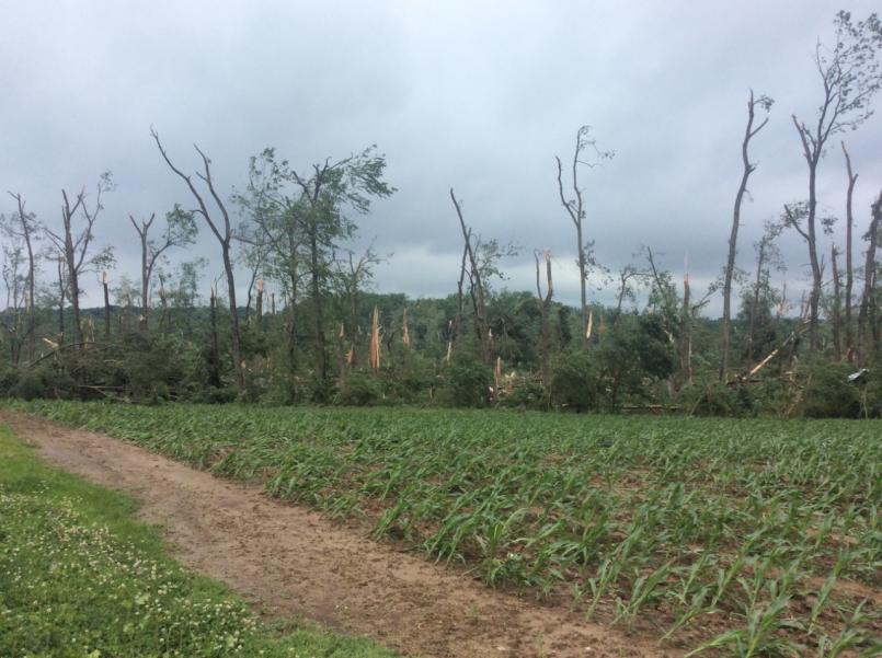
In terms of official surveys, I wasn't aiming for any specifically; I meant the official damage survey, as opposed to stuff in Storm Data, as not everything is easily available via NOAA and the like.
 
Logo 468x120
Back
Top