• Welcome to TalkWeather!
    We see you lurking around TalkWeather! Take the extra step and join us today to view attachments, see less ads and maybe even join the discussion.
    CLICK TO JOIN TALKWEATHER
Messages
2,157
Reaction score
2,713
Location
Missouri
I wonder why they didn’t seem to think it was a significant event or archive photographs
Well, if they're not used to tornadoes then they probably don't have a frame of reference to properly contextualize how historic this event was.
It's amazing how most of history has been lost to the ravages of time; stuff like this is why.
 
Messages
2,157
Reaction score
2,713
Location
Missouri
It's absolutely maddening how many people/businesses/groups/etc. said that they had tons of photos but they either somehow got misplaced or thrown out over the years. Most people (aside from survivors obviously) have no real conception of the outbreak's significance - it's just "that tornado that happened in the 80s" or whatever. I even talked to a guy who took photos documenting the damage at the Sawhill plant for insurance, which probably would've been the best photos I could get my hands on outside of the damage survey, but he said they threw them all out once they were no longer needed. I felt like having a stroke lol
It's amazing how many historical records have been lost to time due to stuff like this; really though, it's not like the guy could have foreseen the rise of the Internet and how there was gonna be easier ways to store information instead of having it take up physical space, which likely was why these photos were thrown away. Records are disposed of all the time, it's simply a matter of practicality. Really frustrating but I'm sure he was only doing it due to orders from the higher-ups above.
 

andyhb

Member
Messages
1,033
Reaction score
2,689
Location
Norman, OK
Given the date and that it's the 50th anniversary today, I would love to see more photos/information on the Sunray/Gruver TX tornado event on 6/9/1971 that was legendary in storm enthusiast circles and was considered by many to be the benchmark Panhandle tornado event until 6/8/1995. Have seen some pictures from the Sunray tornado and it looked spectacular, and apparently there were several other huge, slow moving tornadoes that day.

Screen Shot 2021-06-09 at 6.13.23 PM.png
This is from Peterson 1976 (BAMS) of the Sunray tornado.

Screen Shot 2021-06-09 at 6.31.40 PM.png
This is from Pearson and Wilson 1972 of the Morse tornado.
 
Last edited:
Messages
2,157
Reaction score
2,713
Location
Missouri
The PermaGrain facility in the Quehanna Wild Area, yeah. I'm still trying to find the inspection report, but from what I understand, it was mostly roof and siding damage. The tornado didn't strike it directly. There was also a fire, but it didn't cause any damage to the reactor. A trailer that was being used as an office nearby seems to be the only thing that was hard-hit.
Speaking of nuclear plants and tornadoes, Hackleburg came within 2 miles of the Browns Ferry Nuclear Plant and triggered an emergency shutdown of some of the plant's nuclear reactors. Makes me wonder how long until an EF4+ tornado makes a direct hit on a nuclear power plant....amazing how many disasters have been narrowly averted in events like these.
 
Messages
2,157
Reaction score
2,713
Location
Missouri
Random question but does anyone have any photographs of Hackleburg while it crossed the Tennessee River? I haven't been able to find many damage photographs from that area.
 

MNTornadoGuy

Member
Messages
1,612
Reaction score
2,568
Location
Apple Valley, MN
Given the date and that it's the 50th anniversary today, I would love to see more photos/information on the Sunray/Gruver TX tornado event on 6/9/1971 that was legendary in storm enthusiast circles and was considered by many to be the benchmark Panhandle tornado event until 6/8/1995. Have seen some pictures from the Sunray tornado and it looked spectacular, and apparently there were several other huge, slow moving tornadoes that day.

View attachment 9828
This is from Peterson 1976 (BAMS) of the Sunray tornado.

View attachment 9829
This is from Pearson and Wilson 1972 of the Morse tornado.
I believe one of the tornadoes was reported to have been over two miles wide
 
Messages
2,157
Reaction score
2,713
Location
Missouri
I believe one of the tornadoes was reported to have been over two miles wide
Gruver was 2+ miles wide, Grazulis mentioned it as being the widest on record at the time; of course it's since been surpassed by several other wedges.
The Wikipedia article on Gruver, TX mentions the tornado but doesn't cite a single source for it, wondering if they just copied it from Grazulis as I don't have his book.
 

MNTornadoGuy

Member
Messages
1,612
Reaction score
2,568
Location
Apple Valley, MN
Gruver was 2+ miles wide, Grazulis mentioned it as being the widest on record at the time; of course it's since been surpassed by several other wedges.
The Wikipedia article on Gruver, TX mentions the tornado but doesn't cite a single source for it, wondering if they just copied it from Grazulis as I don't have his book.
It’s quite unusual to see a 2-mile wide tornado with such a high base.
 

Marshal79344

Member
Messages
361
Reaction score
1,064
Location
Chicago, IL
Today's the 63rd anniversary of one of the most unique cases of violent tornadogenesis in Plains history. From a photo standpoint, the El Dorado, Kansas Tornado of June 10th, 1958 appeared to be like any other Plains tornado, tall, photogenic, and slow-moving. However, the truth behind the formation of this tornado definitely sets it apart from any other Plains Tornado.

Most severe weather events in the Great Plains (Texas, Oklahoma, Kansas) will occur in the month of May. The further the year goes on, the further north the low-pressure systems that produce some of the most famous tornado outbreaks go. In simple words, as it transitions from May to June, tornadoes tend to move further north. Major tornadoes in June - August in the Great Plains region tend to occur from small low-pressure systems, a low-pressure system so large that it generates a massive tornado outbreak or a "mesoscale accident," the term used when a factor in the environment that isn't easily forecasted ahead of time plays a significant part in the formation of a tornado. The third option, the "mesoscale accident" was the main driver behind June 10th, 1958.

In 1958, meteorology was nowhere near as advanced as it is today. Back then, we didn't have the NEXRAD WSR-88 type radars we see today. Only primitive technology capable of making out a blurry reflectivity map was in existence. Given the fact that not all tornado-producing storms exhibit a hook echo, mesoscale tornado forecasting back then was not easy. However, one crucial piece of data that did exist on June 10th, 1958 was the sounding. June severe weather events in the Plains always tend to have massive instability values, but usually don't have the kinematic support needed for major tornado events, which is usually seen in May. Reanalysis data for Fort Smith, AR on June 10th, 1958, a city within the brunt of the warm sector showed a multitude of problems that would preclude the formation of a tornado, however.

The observed sounding from Fort Smith on June 10th, 1958:

19580610.png

First, beginning at approximately 770 Mb is a massive temperature spread. Such a spread is detrimental to the vertical stretching that is essential for the formation of tornadoes, especially in the Plains when kinematic support is not as strong. A spread as large as the one seen on that sounding would surely be detrimental to tornado formation. Next, there is a minor cap above the inversion, which is also not supportive of supercell formation. Any supercell that would form in this type of environment would only be capable of producing hail and winds, given the massive temperature spread and elevated nature.

However, despite such an unfavorable environment, there is a factor that can overcome these setbacks. It's called the warm front. First, moisture is almost always higher and more pronounced along the warm front than anywhere else in the main warm sector in the Plains. This would help to decrease the temperature spread to potentially a level conducive enough for surface-based activity, and as a result conducive for tornadoes. Next, the lower-level winds are always more backed along the warm front. This would help to increase streamwise vorticity in the environment, and as a result, make it more favorable for the formation of a tornado. This was most likely the case on June 10th, 1958, using evidence from photos of the parent supercell and the El Dorado Tornado itself.

A photograph of the El Dorado Tornado taking aim at the doomed town:

19580610ELDORADO6.jpg

The first thing that you noticed in this photo of the El Dorado Tornado is how high-based it was. However, it's obvious that the parent supercell was surface-based, knowing that it was producing a mesocyclonic F4 Tornado (photos of the tornado forming also prove that it was indeed produced by a mesocyclone). Reanalysis data showed that any supercell would have quite a high base, which is consistent with this photo of the tornado. It's clear that the base of the parent supercell was most definitely below 700 Mb, likely around 850. If the base was around 700 Mb, it would not be visible in this photo at all. The estimate of 850 Mb is realistic because when looking at similarily tall tornadoes (Rozel, June 9, 1971), reanalysis and observed sounding data for those pointed to an LCL height of 850 Mb. Thus, the moisture was able to reduce the temperature spread to a value supportive of tornado formation. Since the base of the supercell is still high, it is also evident that there was still some form of a temperature - dewpoint spread present, just not significant enough to prevent tornadogenesis.

Next, in order to break down what modern-day radar likely would have seen and what the wind shear values looked like, crucial evidence comes from the track of the tornado itself. The tornado traveled in a straight, uniformed track and remained in a steady state until it began to rope out while it was hitting El Dorado. Along the warm front, it is common to see several supercells fire and activity grow upscale quickly. Supercells do not have a big-time window to produce tornadoes in these environments, and often end up not doing so. However, we have clear and very important evidence that a violent F4 tornado was produced. The supercell responsible for the tornado most definitely remained isolated along the warm front just long enough to produce the tornado. Now that we know how the tornado formed, how did it dissipate? Well, given what we usually see today with warm front supercell activity and the sudden weakening and end of the tornado, convective interference with the tornado's inflow was likely the culprit. As convective mergers occurred, the line likely grew upscale into a major wind and hail producer. This is further supported by the fact that no other tornadoes were reported anywhere nearby that day.

In conclusion, the El Dorado Tornado was produced by a supercell thunderstorm that fired along the warm front and quickly benefitted from enhanced conditions along it in order to produce the tornado. The tornado reached F4 intensity and continued in a steady manner until it dissipated due to convective interference from the formation of other cells along the warm front. However, the convective interference did not arrive quickly enough to spare El Dorado. Evidence left behind from the tornado's damage suggests that it most definitely was a violent (F4+) tornado as well. Several homes were swept away and wind-rowed along the tornado's track. Trees were also severely debarked as well.
 

buckeye05

Member
Messages
3,121
Reaction score
4,581
Location
Colorado
Today's the 63rd anniversary of one of the most unique cases of violent tornadogenesis in Plains history. From a photo standpoint, the El Dorado, Kansas Tornado of June 10th, 1958 appeared to be like any other Plains tornado, tall, photogenic, and slow-moving. However, the truth behind the formation of this tornado definitely sets it apart from any other Plains Tornado.

Most severe weather events in the Great Plains (Texas, Oklahoma, Kansas) will occur in the month of May. The further the year goes on, the further north the low-pressure systems that produce some of the most famous tornado outbreaks go. In simple words, as it transitions from May to June, tornadoes tend to move further north. Major tornadoes in June - August in the Great Plains region tend to occur from small low-pressure systems, a low-pressure system so large that it generates a massive tornado outbreak or a "mesoscale accident," the term used when a factor in the environment that isn't easily forecasted ahead of time plays a significant part in the formation of a tornado. The third option, the "mesoscale accident" was the main driver behind June 10th, 1958.

In 1958, meteorology was nowhere near as advanced as it is today. Back then, we didn't have the NEXRAD WSR-88 type radars we see today. Only primitive technology capable of making out a blurry reflectivity map was in existence. Given the fact that not all tornado-producing storms exhibit a hook echo, mesoscale tornado forecasting back then was not easy. However, one crucial piece of data that did exist on June 10th, 1958 was the sounding. June severe weather events in the Plains always tend to have massive instability values, but usually don't have the kinematic support needed for major tornado events, which is usually seen in May. Reanalysis data for Fort Smith, AR on June 10th, 1958, a city within the brunt of the warm sector showed a multitude of problems that would preclude the formation of a tornado, however.

The observed sounding from Fort Smith on June 10th, 1958:

View attachment 9831

First, beginning at approximately 770 Mb is a massive temperature spread. Such a spread is detrimental to the vertical stretching that is essential for the formation of tornadoes, especially in the Plains when kinematic support is not as strong. A spread as large as the one seen on that sounding would surely be detrimental to tornado formation. Next, there is a minor cap above the inversion, which is also not supportive of supercell formation. Any supercell that would form in this type of environment would only be capable of producing hail and winds, given the massive temperature spread and elevated nature.

However, despite such an unfavorable environment, there is a factor that can overcome these setbacks. It's called the warm front. First, moisture is almost always higher and more pronounced along the warm front than anywhere else in the main warm sector in the Plains. This would help to decrease the temperature spread to potentially a level conducive enough for surface-based activity, and as a result conducive for tornadoes. Next, the lower-level winds are always more backed along the warm front. This would help to increase streamwise vorticity in the environment, and as a result, make it more favorable for the formation of a tornado. This was most likely the case on June 10th, 1958, using evidence from photos of the parent supercell and the El Dorado Tornado itself.

A photograph of the El Dorado Tornado taking aim at the doomed town:

View attachment 9832

The first thing that you noticed in this photo of the El Dorado Tornado is how high-based it was. However, it's obvious that the parent supercell was surface-based, knowing that it was producing a mesocyclonic F4 Tornado (photos of the tornado forming also prove that it was indeed produced by a mesocyclone). Reanalysis data showed that any supercell would have quite a high base, which is consistent with this photo of the tornado. It's clear that the base of the parent supercell was most definitely below 700 Mb, likely around 850. If the base was around 700 Mb, it would not be visible in this photo at all. The estimate of 850 Mb is realistic because when looking at similarily tall tornadoes (Rozel, June 9, 1971), reanalysis and observed sounding data for those pointed to an LCL height of 850 Mb. Thus, the moisture was able to reduce the temperature spread to a value supportive of tornado formation. Since the base of the supercell is still high, it is also evident that there was still some form of a temperature - dewpoint spread present, just not significant enough to prevent tornadogenesis.

Next, in order to break down what modern-day radar likely would have seen and what the wind shear values looked like, crucial evidence comes from the track of the tornado itself. The tornado traveled in a straight, uniformed track and remained in a steady state until it began to rope out while it was hitting El Dorado. Along the warm front, it is common to see several supercells fire and activity grow upscale quickly. Supercells do not have a big-time window to produce tornadoes in these environments, and often end up not doing so. However, we have clear and very important evidence that a violent F4 tornado was produced. The supercell responsible for the tornado most definitely remained isolated along the warm front just long enough to produce the tornado. Now that we know how the tornado formed, how did it dissipate? Well, given what we usually see today with warm front supercell activity and the sudden weakening and end of the tornado, convective interference with the tornado's inflow was likely the culprit. As convective mergers occurred, the line likely grew upscale into a major wind and hail producer. This is further supported by the fact that no other tornadoes were reported anywhere nearby that day.

In conclusion, the El Dorado Tornado was produced by a supercell thunderstorm that fired along the warm front and quickly benefitted from enhanced conditions along it in order to produce the tornado. The tornado reached F4 intensity and continued in a steady manner until it dissipated due to convective interference from the formation of other cells along the warm front. However, the convective interference did not arrive quickly enough to spare El Dorado. Evidence left behind from the tornado's damage suggests that it most definitely was a violent (F4+) tornado as well. Several homes were swept away and wind-rowed along the tornado's track. Trees were also severely debarked as well.
There used to be a photo of an extensively anchor-bolted hone that was completely swept away by this tornado floating around, but seems to have disappeared. Was definitely an F5 candidate.
 

MNTornadoGuy

Member
Messages
1,612
Reaction score
2,568
Location
Apple Valley, MN
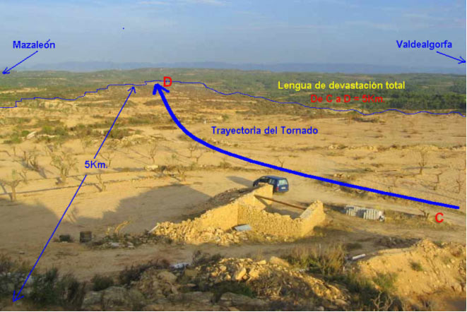
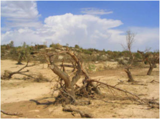
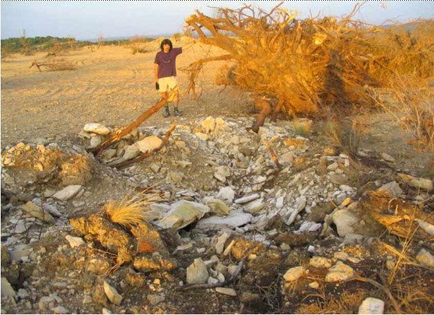
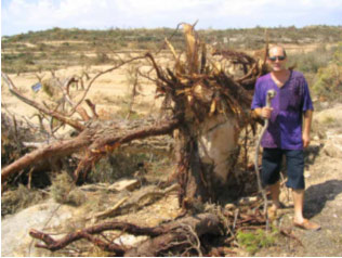
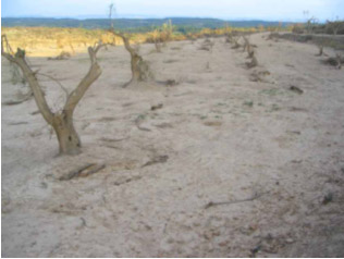
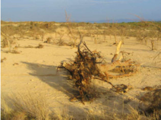
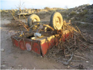
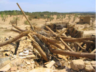
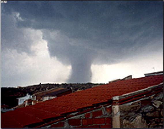
One notable Spanish tornado is the July 23, 2003 Alcañiz tornado. This large stovepipe tornado traveled 8-10 km and reached a width of up to 800 meters. Some industrial buildings were damaged with nearby 440 lb extractors and cars were thrown up to 200 meters, and 4-5 farmhouses were destroyed with an 1102 lb wagon being tossed 400 meters. Groves of trees were stripped, snapped, or uprooted and topsoil up 30 cm in depth "completely disappeared."
foto21.jpg

foto25.jpg

foto31.jpg

foto32.jpg

foto39.jpg

foto36.jpg

foto50.jpg

foto53.jpg

foto01.jpg
 

Marshal79344

Member
Messages
361
Reaction score
1,064
Location
Chicago, IL
One notable Spanish tornado is the July 23, 2003 Alcañiz tornado. This large stovepipe tornado traveled 8-10 km and reached a width of up to 800 meters. Some industrial buildings were damaged with nearby 440 lb extractors and cars were thrown up to 200 meters, and 4-5 farmhouses were destroyed with an 1102 lb wagon being tossed 400 meters. Groves of trees were stripped, snapped, or uprooted and topsoil up 30 cm in depth "completely disappeared."
foto21.jpg

foto25.jpg

foto31.jpg

foto32.jpg

foto39.jpg

foto36.jpg

foto50.jpg

foto53.jpg

foto01.jpg
Photos will not seem to load.
 

TH2002

Member
Sustaining Member
Messages
3,116
Reaction score
4,677
Location
California, United States
Special Affiliations
  1. SKYWARN® Volunteer
One Russian tornado outbreak that interests me is the June 18, 2017 tornado outbreak. Impacting regions struck by tornadoes merely two weeks earlier, this outbreak resulted in 16 tornadoes including one rated a violent F4 (though the homes leveled were log cabins and even then I am unsure if they were well-anchored or not). Entire swaths of trees were also mowed down and debarked. Aside from this however, there is practially no information and damage pictures are unfortunately nowhere to be found.

Here's one of the only videos I've found from this outbreak; you're free to decide if the video shows a downburst or the outer circulation of a tornado.
 

MNTornadoGuy

Member
Messages
1,612
Reaction score
2,568
Location
Apple Valley, MN
One Russian tornado outbreak that interests me is the June 18, 2017 tornado outbreak. Impacting regions struck by tornadoes merely two weeks earlier, this outbreak resulted in 16 tornadoes including one rated a violent F4 (though the homes leveled were log cabins and even then I am unsure if they were well-anchored or not). Entire swaths of trees were also mowed down and debarked. Aside from this however, there is practially no information and damage pictures are unfortunately nowhere to be found.

Here's one of the only videos I've found from this outbreak; you're free to decide if the video shows a downburst or the outer circulation of a tornado.

I made a post about this outbreak awhile back
 

TH2002

Member
Sustaining Member
Messages
3,116
Reaction score
4,677
Location
California, United States
Special Affiliations
  1. SKYWARN® Volunteer
Back
Top