
tornadowatch211
Member
Screw JUST Tri-State, I mapped the whole outbreak (3/18/1925)

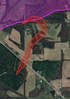
Kansas: Dearing F2

Missouri: Blair Creek F2+, Tri-State (already sent image of TST)

Illinois: Tri-State (already sent), Satellites (1. Murphysboro 2. Parrish 3. Dale)


Indiana: Tri-State (already sent), Satellite (Princeton), Willisville F2 and F?, Tampico F4, Laconia F4+


Part 2 includes Kentucky, Tennessee, and Alabama.
Kansas: Dearing F2
Missouri: Blair Creek F2+, Tri-State (already sent image of TST)
Illinois: Tri-State (already sent), Satellites (1. Murphysboro 2. Parrish 3. Dale)
Indiana: Tri-State (already sent), Satellite (Princeton), Willisville F2 and F?, Tampico F4, Laconia F4+
Part 2 includes Kentucky, Tennessee, and Alabama.
Attachments
Last edited:


