
It was pretty gnarly. I thought it was going to be a EF4 based off radar imagery but only ended up ef3. That event sticks out most because of this tornado video. One of my favorite all time in Alabama.I have actually never heard about this tornado. But it 100% looks more intense on radar than the Newnan tornado did.
Navigation
Install the app
How to install the app on iOS
Follow along with the video below to see how to install our site as a web app on your home screen.
Note: This feature may not be available in some browsers.
More options
-
Welcome to TalkWeather! We see you lurking around TalkWeather! Take the extra step and join us today to view attachments, see less ads and maybe even join the discussion. CLICK TO JOIN TALKWEATHER
You are using an out of date browser. It may not display this or other websites correctly.
You should upgrade or use an alternative browser.
You should upgrade or use an alternative browser.
Significant Tornado Events
- Thread starter locomusic01
- Start date
What the SPC would have drawn up for 4/3/74 is an interesting scenario to game out here.I think it would look similar to March 2, 2012 as well, except with the high risk brought down into MS and AL with one or two 45% contours for the areas with the highest confidence in a violent tornado threat, one in the northern mode and another in the southern mode.
My personal theory is you would’ve had the initial day 1 High Risk centered over most of Western, Southern, and Central KY, the bottom half of Indiana, and most of southwestern to south central Ohio. With a moderate stretching from as far as northern Indiana down to north Mississippi and north and central Alabama, covering almost all of Tennessee east of Nashville. With an enhanced pretty much wrapping around a vast majority of the Ohio and MS river valleys and parts of NC, Georgia, Arkansas, and Missouri.
The Indiana/KY/Ohio event was about as slam dunk as you could get. A 100+ knot 500 MB isotach punching and overlapping an extremely unstable warm sector. The late morning MCS had also accelerated away from those areas extremely quickly so it didn’t leave any cold pools, only boundaries for later storms. Plus you still had enough forcing to get things going in Northern & Central TN.
Southern TN on down to Alabama, Mississippi, and Northern Georgia would be a different story. I think the SPC would have been more conditional here and this is why: The trough was more of a glancing blow onto the warm sector, so your storm mode, while discrete, coverage would be in question. The southern portion of the morning MCS after separating from the northern part actually slowed down and slogged eastward. It was putting a tornado down in Cleveland TN a mere two hours before the whole event kicked off. You also ran the risk of the cap not fully eroding. Weather reports from Alabama and Mississippi that day all mention severe storms before the tornadic round, with a strong southerly wind and overcast skies. In the end, that didn’t matter though, and you still either through the dryline or some other mesoscale boundary interaction had 4-5 cells track across the southern portion of Alabama, Georgia, and southern TN.
CheeselandSkies
Member
I have actually never heard about this tornado. But it 100% looks more intense on radar than the Newnan tornado did.
Severe WX - Severe Threat 25 March 2021
Debris falling out of the sky per Jeff Piotrowski You can hear the roar. Holy hell.
Kds86z
Member
Thank you for this detailed scenario.What the SPC would have drawn up for 4/3/74 is an interesting scenario to game out here.
My personal theory is you would’ve had the initial day 1 High Risk centered over most of Western, Southern, and Central KY, the bottom half of Indiana, and most of southwestern to south central Ohio. With a moderate stretching from as far as northern Indiana down to north Mississippi and north and central Alabama, covering almost all of Tennessee east of Nashville. With an enhanced pretty much wrapping around a vast majority of the Ohio and MS river valleys and parts of NC, Georgia, Arkansas, and Missouri.
The Indiana/KY/Ohio event was about as slam dunk as you could get. A 100+ knot 500 MB isotach punching and overlapping an extremely unstable warm sector. The late morning MCS had also accelerated away from those areas extremely quickly so it didn’t leave any cold pools, only boundaries for later storms. Plus you still had enough forcing to get things going in Northern & Central TN.
Southern TN on down to Alabama, Mississippi, and Northern Georgia would be a different story. I think the SPC would have been more conditional here and this is why: The trough was more of a glancing blow onto the warm sector, so your storm mode, while discrete, coverage would be in question. The southern portion of the morning MCS after separating from the northern part actually slowed down and slogged eastward. It was putting a tornado down in Cleveland TN a mere two hours before the whole event kicked off. You also ran the risk of the cap not fully eroding. Weather reports from Alabama and Mississippi that day all mention severe storms before the tornadic round, with a strong southerly wind and overcast skies. In the end, that didn’t matter though, and you still either through the dryline or some other mesoscale boundary interaction had 4-5 cells track across the southern portion of Alabama, Georgia, and southern TN.
Another fascinating thing to me about the 4/3/74 outbreak is that the southern tornados (Tanner 1 & 2, Jasper, Guin, two of the Georgia tornados) were almost completely different in character than their northern counterparts. Very long tracked, very violent, and fast moving tornados. I know Corfidi puts them in convective band 2, but judging by their late afternoon/early evening start time, I almost posit that the dryline or some other unknown mesoscale forcing like outflow boundaries caused that very violent round of the outbreak.
I could talk about 4/3/74 all day. As violent as 4/27/11 was, a system that can put a F5 all the way up in Indiana down to Alabama with multiple violent tornados in between, stands above all the rest.Thank you for this detailed scenario.
If @wx_guy ’s computer is doing okay after the recent marathon, I’d love to see a 4/3/74 simulation run
")
Last edited:
Aaron Rider
Member
I don't know if this has been asked, but are there any F-5 tornadoes pre-2007 that would be rated EF-5 today? Like I know there are a few like Niles, OH-Wheatland, PA and Bridge Creek-Moore, OK. But what would be some other examples?
Agreed on all these.I am confident in saying that Andover, Bridge Creek/Moore 1999, Jarrell TX, Niles/Wheatland, and Brandenburg would still be rated EF5 today.
I would add that I believe these next ones would be rated EF5 unless the office involved was just being ridiculous:
Udall, Kansas 1955
Beecher, Michigan 1953
Hudsonville, Michigan 1956
Ruskin Heights KC, Missouri 1957
Pittsfield - Strongsville, Ohio 1965*
Dunlap (Sunnyside), Indiana 1965*
Candlestick Park, Mississippi 1966
Topeka, Kansas 1966
Tracy, Minnesota 1968 - unless they quibbled with construction; the contextuals were extreme
Guin Alabama 1974
Brownwood, Texas 1976 - this thing may have been way stronger than I initially thought
Jordan, Iowa 1976
Oakfield, Wisconsin 1996 - tore vehicles apart; scoured crops to nothing; bent rebar supports at a well-built home it destroyed... I'm satisfied
Lawrence County, Tennessee 1998
*Not officially F5
Why these? Because the EF5 rating seems to have two problems: one is that it seems to be granted only to what I would call *high end F5* if that makes sense; the other is a deep reticence to consistently apply it to tornadoes that are not just old school F5, but good enough for this apparent absolutely extreme standard. That said, the tornadoes you mention plus the ones above were absolutely extreme.
With Goessel and hesston, among others, I just don't know much about them.
You just never know with the rest. The 1958 Colfax, Wisconsin tornado swept away homes and did high end contextual damage. That should be good enough but it and several other official F5s would probably get ignored.
I tend to be pretty moderate in my attitudes towards the EF5 scale, but, well, we all know what the deal is. And, again, you never know. If Vilonia isn't EF5..... but assuming a modicum of sanity, I think that's our list of no brainers
Note that the question kinda inevitably becomes implicitly a question of, which tornadoes were the most violent even amongst F5s? Which is fine, of course, and a fun topic.
Aaron Rider
Member
Amazing. And let me tell you, that terrain is way rougher than these pictures can adequately express.
AJS
Member
I consider Hesston to have been a legitimate F5 tornado. There was some research dug up earlier on this thread that this tornado produced extreme contextual damage and proof that it swept away anchor bolted homes. It was definitely worthy of its F5 rating.Agreed on all these.
I would add that I believe these next ones would be rated EF5 unless the office involved was just being ridiculous:
Udall, Kansas 1955
Beecher, Michigan 1953
Hudsonville, Michigan 1956
Ruskin Heights KC, Missouri 1957
Pittsfield - Strongsville, Ohio 1965*
Dunlap (Sunnyside), Indiana 1965*
Candlestick Park, Mississippi 1966
Topeka, Kansas 1966
Tracy, Minnesota 1968 - unless they quibbled with construction; the contextuals were extreme
Guin Alabama 1974
Brownwood, Texas 1976 - this thing may have been way stronger than I initially thought
Jordan, Iowa 1976
Oakfield, Wisconsin 1996 - tore vehicles apart; scoured crops to nothing; bent rebar supports at a well-built home it destroyed... I'm satisfied
Lawrence County, Tennessee 1998
*Not officially F5
Why these? Because the EF5 rating seems to have two problems: one is that it seems to be granted only to what I would call *high end F5* if that makes sense; the other is a deep reticence to consistently apply it to tornadoes that are not just old school F5, but good enough for this apparent absolutely extreme standard. That said, the tornadoes you mention plus the ones above were absolutely extreme.
With Goessel and hesston, among others, I just don't know much about them.
You just never know with the rest. The 1958 Colfax, Wisconsin tornado swept away homes and did high end contextual damage. That should be good enough but it and several other official F5s would probably get ignored.
I tend to be pretty moderate in my attitudes towards the EF5 scale, but, well, we all know what the deal is. And, again, you never know. If Vilonia isn't EF5..... but assuming a modicum of sanity, I think that's our list of no brainers
Note that the question kinda inevitably becomes implicitly a question of, which tornadoes were the most violent even amongst F5s? Which is fine, of course, and a fun topic.
TH2002
Member
- Messages
- 4,973
- Reaction score
- 11,113
- Location
- California, United States
- Special Affiliations
- SKYWARN® Volunteer
Here's more damage in the Hillcrest Meadows area. The leveled home in the foreground here was given an F4 rating as well:Expanding upon this, here's the damage in Hillcrest Meadows that BMX specifically denotes as being rated F4, and thus presumably the most severe damage done; I assume this would get EF3 now while EF2 is very clearly absurd
View attachment 39493
Aerial of the same area (the leveled home is visible near the water tower):
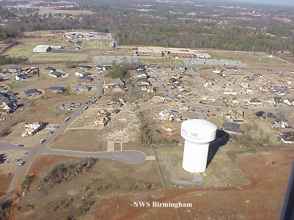
Also haven't seen that bit about the semi being thrown 600 yards before; definitely another piece of evidence pointing to a violent tornado there.
And FWIW, the organization behind the "study" that gave this tornado an F2 rating was none other than Texas Tech University, the same people who ruined the Matador survey. Frustrating, but not surprising either, and it gives further insight into their poor understanding of tornado damage hallmarks and their absurdly conservative damage surveys.
Kds86z
Member
What year is this?Here's more damage in the Hillcrest Meadows area. The leveled home in the foreground here was given an F4 rating as well:

Aerial of the same area (the leveled home is visible near the water tower):
Also haven't seen that bit about the semi being thrown 600 yards before; definitely another piece of evidence pointing to a violent tornado there.
And FWIW, the organization behind the "study" that gave this tornado an F2 rating was none other than Texas Tech University, the same people who ruined the Matador survey. Frustrating, but not surprising either, and it gives further insight into their poor understanding of tornado damage hallmarks and their absurdly conservative damage surveys.
And FWIW, the organization behind the "study" that gave this tornado an F2 rating was none other than Texas Tech University, the same people who ruined the Matador survey. Frustrating, but not surprising either, and it gives further insight into their poor understanding of tornado damage hallmarks and their absurdly conservative damage surveys.
Texas Tech actually created the EF Scale
TH2002
Member
- Messages
- 4,973
- Reaction score
- 11,113
- Location
- California, United States
- Special Affiliations
- SKYWARN® Volunteer
2000What year is this?
Not by themselves, thank goodness.Texas Tech actually created the EF Scale
Though I wouldn't be surprised if the "revised" wind speed estimates created for the EF scale were done solely by TTU, based on the fact that said wind speeds are obviously too low on the upper end of the scale.
Not by themselves, thank goodness.
Though I wouldn't be surprised if the "revised" wind speed estimates created for the EF scale were done solely by TTU, based on the fact that said wind speeds are obviously too low on the upper end of the scale.
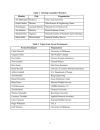
Yeah, they recruited quite the committee! I've attached the list of participants for anyone interested. It's disappointing tornado damage hasn't been simulated with modern technology to try and get the most accurate possible wind speed to damage results.
Texas Tech straight up said it was too much money and work:
"Both of these approaches are time-consuming and expensive. The TTU project did not have sufficient resources available to carry out a full-blown study using either the deterministic or simulation approach"
They referenced the success of using a committee to determine earthquake strength ratings, but at least earthquake damage experts have direct evidence from ground based measurements.
Preaching to the choir here, but to take something as little understood as tornado physics and build a rating system based on some experts' "hunches" seems kinda reckless and irresponsible in hindsight lol. Plus, Ted Fujita DID have the time, money, and resources to simulate and determine tornado wind speeds. Which is how he came up with the F scale DI winds in the first place! To just toss it out so carelessly and half-baked was pretty disrespectful to all the work he did IMO.
Attachments
DanLarsen34
Member
I think you may be right with the initial outlook. However, I’d argue for the southern mode still being a high risk as well given that glancing blows are often more favorable for high-end Dixie events as Trey Greenwood has outlined in many of his forecast discussions. In a way, these kind of set-up tends to favor at least a bi-modal risk.What the SPC would have drawn up for 4/3/74 is an interesting scenario to game out here.
My personal theory is you would’ve had the initial day 1 High Risk centered over most of Western, Southern, and Central KY, the bottom half of Indiana, and most of southwestern to south central Ohio. With a moderate stretching from as far as northern Indiana down to north Mississippi and north and central Alabama, covering almost all of Tennessee east of Nashville. With an enhanced pretty much wrapping around a vast majority of the Ohio and MS river valleys and parts of NC, Georgia, Arkansas, and Missouri.
The Indiana/KY/Ohio event was about as slam dunk as you could get. A 100+ knot 500 MB isotach punching and overlapping an extremely unstable warm sector. The late morning MCS had also accelerated away from those areas extremely quickly so it didn’t leave any cold pools, only boundaries for later storms. Plus you still had enough forcing to get things going in Northern & Central TN.
Southern TN on down to Alabama, Mississippi, and Northern Georgia would be a different story. I think the SPC would have been more conditional here and this is why: The trough was more of a glancing blow onto the warm sector, so your storm mode, while discrete, coverage would be in question. The southern portion of the morning MCS after separating from the northern part actually slowed down and slogged eastward. It was putting a tornado down in Cleveland TN a mere two hours before the whole event kicked off. You also ran the risk of the cap not fully eroding. Weather reports from Alabama and Mississippi that day all mention severe storms before the tornadic round, with a strong southerly wind and overcast skies. In the end, that didn’t matter though, and you still either through the dryline or some other mesoscale boundary interaction had 4-5 cells track across the southern portion of Alabama, Georgia, and southern TN.
If there were any questions regarding convective coverage earlier in the day with the southern mode, my guess is that new data would have likely resolved those concerns by the afternoon or final Day 1 outlook if this were to happen today. Hell, the SPC may still issue a high risk anyway in that scenario given that the environment would be extremely favorable for violent, long-track tornadoes in the southern mode. In fact, we’ve seen them do this with a couple of recent higher-potential days (March 15th this year, March 25, 2021) with the most notable exception being April 12, 2020.
Without more detailed, real-time data from the 1974 Outbreak, though, it’s hard to say for certain what the outlook boundaries would have looked like. Whatever gaps we had then would likely be resolved today with all of the available data we have.
CheeselandSkies
Member
It's the 10th anniversary of the Rochelle-Fairdale, IL EF4 (oft cited as one of the "EF5 candidates," since its wind speed was pegged right at 200 MPH). It killed two people, IIRC they were both in/near Fairdale.

 en.wikipedia.org
For me, it was the second demoralizing miss of a spectacular tornado event in as many years. These photos were taken between 3 and 4 PM along Illinois Highway 26 just north of Forreston, a little over 20 miles from where the tornado would touch down about 90 minutes later. Just as I thought I'd broken through the warm front, I kept encountering more showers (I now realize these were the incipient updrafts that amalgamate over time to form tornadic supercells in these type of events). Even as things cleared out and I started to see bubbly cumulus, I felt it was still too cool at the surface and too late in the day for sufficient destabilization. I decided it would probably play out similar to the previous year's April 28th, which I had also chased (apart from the moderate/later high risk down south, that day was also expected to be favorable for tornadoes closer to the main surface low in northern Illinois), with just a band of grungy, featureless outflow-dominant storms forming. On top of this, the "CHECK ENGINE" light in the car I had at the time (2005 Ford Focus hatchback) had come on during the drive down, and I didn't know how serious it was.
I drove home only to pull up GR Level 3 on my desktop just as the monster hook and velocity couplet appeared. Pretty sure I literally banged my forehead into my desk several times.


2015 Rochelle–Fairdale tornado - Wikipedia
For me, it was the second demoralizing miss of a spectacular tornado event in as many years. These photos were taken between 3 and 4 PM along Illinois Highway 26 just north of Forreston, a little over 20 miles from where the tornado would touch down about 90 minutes later. Just as I thought I'd broken through the warm front, I kept encountering more showers (I now realize these were the incipient updrafts that amalgamate over time to form tornadic supercells in these type of events). Even as things cleared out and I started to see bubbly cumulus, I felt it was still too cool at the surface and too late in the day for sufficient destabilization. I decided it would probably play out similar to the previous year's April 28th, which I had also chased (apart from the moderate/later high risk down south, that day was also expected to be favorable for tornadoes closer to the main surface low in northern Illinois), with just a band of grungy, featureless outflow-dominant storms forming. On top of this, the "CHECK ENGINE" light in the car I had at the time (2005 Ford Focus hatchback) had come on during the drive down, and I didn't know how serious it was.
I drove home only to pull up GR Level 3 on my desktop just as the monster hook and velocity couplet appeared. Pretty sure I literally banged my forehead into my desk several times.
Last edited:
DanLarsen34
Member
So, this feels like the right place to have this discussion.
Back in 2019-2020, I had an idea for an article series that I ultimately never wrote which is a what-if series. The series would have discussed and explored the highest-ceiling days from the past two decades that ultimately fell short of their potential. Specifically, we’re talking about days where had a few subtle factors played out differently, we may have been talking about a once in a decade or generational type event given the insane parameter space that was in place.
This was an idea I got after the May 20, 2019 risk ultimately underperformed relative to what could have happened. During that day and in the immediate aftermath, it wasn’t entirely clear what specific factors threw that event off. Had those subtle factors played out slightly differently (wild fire smoke enhancing the cap, 500 MB wave punching in later than expected, unfavorable storm motions leading to destructive interference, etc…), I truly think this event had the potential to be a “generational” event for the plains like 4/26/1991 was.
Let’s start with events since 2010. What specific days do y’all look at as these potential days? I have a few candidates to help get the ball rolling. This includes some days that were still very notable outbreaks:
1) March 15, 2025 (MS, AL high-risk)
2) May 6, 2024 (OK high risk, Barnsdall tornado)
3) April 4, 2023 (moderate risk that affected the same areas as the March 31 event)
4) March 25, 2021 (MS/AL high risk)
5) May 20, 2019 (TX/OK high-risk)
6) January 22, 2017 (GA, FL high-risk)
CheeselandSkies
Member
So, this feels like the right place to have this discussion.
Back in 2019-2020, I had an idea for an article series that I ultimately never wrote which is a what-if series. The series would have discussed and explored the highest-ceiling days from the past two decades that ultimately fell short of their potential. Specifically, we’re talking about days where had a few subtle factors played out differently, we may have been talking about a once in a decade or generational type event given the insane parameter space that was in place.
This was an idea I got after the May 20, 2019 risk ultimately underperformed relative to what could have happened. During that day and in the immediate aftermath, it wasn’t entirely clear what specific factors threw that event off. Had those subtle factors played out slightly differently (wild fire smoke enhancing the cap, 500 MB wave punching in later than expected, unfavorable storm motions leading to destructive interference, etc…), I truly think this event had the potential to be a “generational” event for the plains like 4/26/1991 was.
Let’s start with events since 2010. What specific days do y’all look at as these potential days? I have a few candidates to help get the ball rolling. This includes some days that were still very notable outbreaks:
1) March 15, 2025 (MS, AL high-risk)
2) May 6, 2024 (OK high risk, Barnsdall tornado)
3) April 4, 2023 (moderate risk that affected the same areas as the March 31 event)
4) March 25, 2021 (MS/AL high risk)
5) May 20, 2019 (TX/OK high-risk)
6) January 22, 2017 (GA, FL high-risk)
I don't think March 25, 2021 underperformed at all in hindsight. If anything from that month did it was March 17, which also included a 45% hatched tornado probability area (matching 4/27 and 5/24/11, and 5/20/19) but only produced four tornadoes rated above the "weak" category (all EF2).
May 25th of 2024 is a notable one. The second day-2 outlook issued on May 24 contained some of the most ominous wording I'd ever seen outside of 4/27 and 5/20/19, especially for a non-Broyles outlook.
However, they held off on the high risk initially due to concerns over lesser storm coverage, but by the time of the first Day-1 outlook it was clear the bigger issue was going to be outflow wrecking the thermodynamics in parts of the warm sector, and potential for destructive storm interactions which did indeed end up significantly limiting the ceiling of the event. As one chaser in the Stormtrack Discord put it: "One left split. I have never before seen a tornado outbreak Atmospheric Anti-Climax by one left split." In keeping with the general theme of last year in the Southern Plains, the most significant tornadoes came after dark.Edit: Can we stop applying the auto-censor to b**t everywhere in this forum? I understand it when people are calling it prematurely in active event threads, but it's getting old, especially when I'm going back and finding it in my posts where I used it in reference to my own chase, not the event in general.
Aaron Rider
Member
Today in tornado history
1947 - the Glazier-Woodward tornado
2015 - Rochelle-Fairdale
1947 - the Glazier-Woodward tornado
2015 - Rochelle-Fairdale
Kds86z
Member
Today in tornado history
1947 - the Glazier-Woodward tornado
2015 - Rochelle-Fairdale
Rochelle was 50 Miles from my sister. My brother in law is an officer and was on the scene. To close!Today in tornado history
1947 - the Glazier-Woodward tornado
2015 - Rochelle-Fairdale