This is fairly old however, having got the entire damage path with all the locations and pictures etc....I still am at a loss as to where true "peak" intensity might have been reached. That said there are a few notable areas of exceptional intensity, I thought I might give my 2 cents on. (green is worse than yellow in damage severity, it is something people have complained about as confusing, but I did not make the colors). I don't think I can do the tornado justice in these limited descriptions I can provide here, however my planned article should hopefully.
I should note that even in Annapolis, it carved a considerable swath of destruction, completely sweeping away businesses, scouring the ground, and producing severe granulation of debris and tree damage. Leadanna also had many homes entirely blown away and heavy mining equipment ripped out, the tipple and other buildings were badly damaged. According to Alice "peachy Jones", the miners from Leadanna had to travel on foot to Annapolis as the roads were covered in debris. Along the way, the miners were stunned to discover boxcars and other freightcars that had tumbled off the tracks. They noted that whilst many were lying on their sides, some had been spun several rotations away.
View attachment 33139
However, later on in Missouri the tornado reached much greater levels of intensity; along Highway 72 in Bollinger County, a half mile wide swath of densely forested timber was completely flat on the ground, to the point where the people had an almost panoramic view of where the distant forests were and where all the trees were destroyed. Three farms here were also completely swept clean, the ground was scoured down to the earth, many trees were completely debarked and reduced to naked stumps. Large hardwoods were ripped out by their root balls leaving very large mounds in the ground. Debris including wooden planks were speared into trees here as well. Sadly there is only one picture of this area, however you do see a hardwood completely debarked and down to its stump knee-height. The depressions and mounds are also still there today.
View attachment 33140
You then have the area in Missouri where many were killed in eastern Bollinger County. Large swaths of forests were completely razed to the ground with hardly anything left standing. A very fine portion of timber, worth over $3,000 in 1925 had "greater portions stripped off" and was debarked. Conrad School had its concrete foundation completely shattered and destroyed, four children were killed in the school. The area North, NW and NE of Lixville has an argument for potentially being the "peak" of Missouri, here many very large and fine farms were completely blown apart, animals were thrown great distances and mutilated, trees were completely flattened and debarked. At Judge Louis Lix's place the tornado destroyed the two barns on the property, the new concrete house of the Judge, ($7k) was badly wrecked and his old home was completely flattened. All trees were destroyed. Also here, a mile long swath of very wide and extremely deep ground scouring occurred as it neared Garner School, all the grass and soil was removed. It continued obliterating farms in Bollinger County and scouring the ground as it hit the ridge of Schumer Springs, cleaving a path several hundred yards wide over the wooded hilltop, uprooting beeches, elms, and maples, and snapping the trunks of 14 inch and 20 inch oaks like twigs.
Near Biehle, several large farms were completely eradicated with little evidence of their prior existence. Debris was thrown far, and trees were reduced to stumps, in many instances cattle were impaled on these. "A mule, caught in the open, was lifted high into the air only to be hurled with a sickening thud, a lifeless mass, to the earth some hundred yards ahead. Three horses, two pigs, and dozens of chickens met a similar fate. Two of the horses were found literally wrapped around the trunk and limbs of a fallen oak, while the other was hurled amid a denser portion of the wood to where its cumbersome body never could have penetrated in life."
Farm machinery was also mangled and left unrecognisable.
View attachment 33141
The tornado also maintained or even possibly exceeded this intensity in Perry County, where very fine homes were flattened as if by a "giant roller". Trees were flattened much like in Bollinger County. Debris was strewn great distances from farm sites too. Many places were just laid to waste entirely. Most interesting I find here is the damage to Claus Stueve, Oscar Petzoldt and the Ridge School.
Stueve had a very large farm, which had about 13 outbuildings, a lot of timber, and a very large, and expensive 2 story stone/concrete mansion. The residence was worth about $30k in 1925, which adjusting for changes in property, wealth and inflation, is over $5 million today. It was wiped clean off the hill and two were killed, the debris was scattered a great distance. Trees were reduced to debarked stumps and the ground was scoured. A similar story at the petzoldt farm where everything was a complete wasteland. Ridge School was a 2-story brick building that was lifted whole and hurled a 100 yards before disintegrating onto the side of a hill.
View attachment 33143
Then you have Illinois, where it essentially maintained F5 strength for the majority of the time. Severe vegetation damage occurred East and West of Gorham, where all the grass and soil was torn away in fields outside of town, trees were entirely debarked and stripped bare. In fact, a 1000 yard swath of trees east of town was left completely flattened that many remarked there were no trees taller than knee height left.
Murphysboro is obvious, many large trees were flattened, snapped, thrown and debarked, the ground was scoured and entire blocks were wiped clean. The large and strong buildings at the yards were completely levelled and even a locomotive was found displaced into the Transfer Pit. Railroad tracks were ripped up here and in Gorham. Tombstones were also ripped up.
However, I believe that the tornado actually intensified in between Murphysboro and De Soto, as farms were entirely swept away without a trace, mature hardwood trees in a very wide swath were snapped at ground level, an iron mountain train was swept off its tracks and a railroad bridge was blown apart. Also severe scouring occurred. And in de soto remarkable damage happened to low lying vegetation, and in general the area was just so thoroughly obliterated to the point where there was almost no debris left and trees were snapped off near ground level.
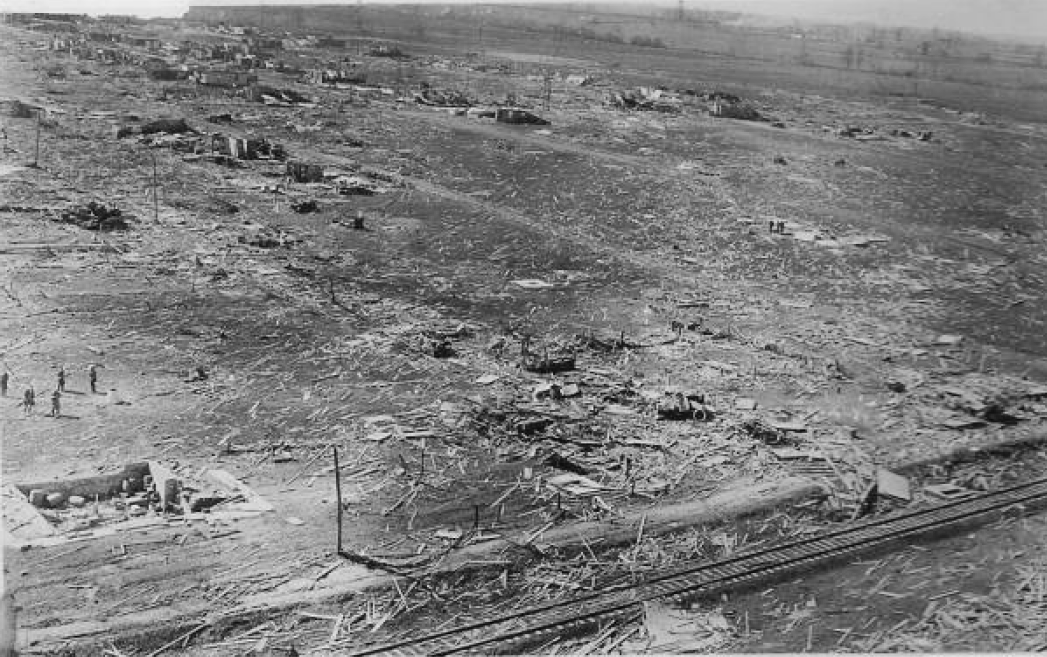
In West Frankfort, Concrete basement walls were sheared off at ground height and blown in, the 288 ton water tower was blown down partly into the ground, and as your picture shows severe granulation, rowing of debris and vehicle damage were present along with scouring. A coal chute at the C.E.I yards was blown away and mangled along with all the buildings and a 300 foot section of track was scoured away. Many large boxcars weighing over 40 tons were lifted bodily into the air and hurled hundreds of yards away. At Caldwell, not a single home was left standing, several people were carried a full mile, one home had all its reinforced concrete basement walls blown in, and the 80 foot mine tipple at Peabody Mine #18, one of the finest Mines of the County was torn down and blown to the ground. All the reinforced buildings nearby were completely demolished. Structurally, I believe this location to be the most intense.
Hamilton and White Counties were extremely violent as 76 were killed in rural areas, farms obliterated, and as seen here, extreme vegetation damage occurred. Pictured below is a photo of the once densely populated, 18 acre woods of C.S Conger. There is so much information on this County that I cannot do it justice here.
View attachment 33144
All that being said, it appears that the consensus amongst the "experts" so to speak, was that it likely attained its highest windspeed in Griffin Indiana, where it reached its peak forward movement, and quite literally wiped the town completely away. Again the damage cannot be given full justice here. But I will note, even in Princeton, it was able to demolish much of the Heinz Plant, which was very well built. As well as displace locomotives and boxcars.
View attachment 33146
Note the flattened car in the foreground carried at least 500 feet.
View attachment 33147View attachment 33145
View attachment 33148