TH2002
Member
- Messages
- 4,973
- Reaction score
- 11,113
- Location
- California, United States
- Special Affiliations
- SKYWARN® Volunteer
January: I think the F4 rating for Allendale is fine, since the homes it destroyed were poorly anchored to cinder block foundations (hell, it would probably get an EF3 rating the way damage surveys are these days). Not aware of any true (E)F5 contenders for the month of January but I think the 1988 Liberty Chapel, MS tornado and 1997 Barfield, TN tornado are contenders for the strongest.Strongest tornadoes by month, at least since 1950:
January: Allendale, IL - 1/7/1989 - probable F5
February: Delhi, LA - 2/21/1971 - rated F5 or Clinton, AR - 2/5/2008 - probable F5
March: Hesston, KS - 3/13/1990 - rated F5
An embarrasment of riches for the months April - June; I won't try to pick one for each, but, from what I've read, the strongest contenders for each include several from SO 1974 and SO 2011 for April, almost too many to count for May, and Flint-Beecher (6/8/1953) and Bakersfield Valley (6/1/1990) for June
July: Oakfield, WI - 7/18/1996 - rated F5
August: Plainfield, IL - 8/18/1990 - rated F5, and appears to be the strongest August twister, but the F5 rating is often reasonably disputed
September: Cobb Town, WI - 9/26/1951 - probable F5
October: Belmond, IA - 10/14/1966 - probable F4 but was rated, most likely incorrectly, as F5; I don't see any other F5 contenders from October
November: Washington, IL - 11/17/2013 - borderline F5, probably was one
December: Holly Springs, MS - 12/23/2015 - almost certainly an F5; may well have been stronger than Mayfield-Bremen
March: for post-1950 I would agree with Hesston, but for the month in general it's Tri-State hands down.
September: will bring up Crosstown 2006 as another contender for the strongest September tornado, as at least one of the homes it slabbed was reportedly well anchored. Don't think it's a solid F5 candidate though as it didn't really produce any extremely impressive contextual damage.
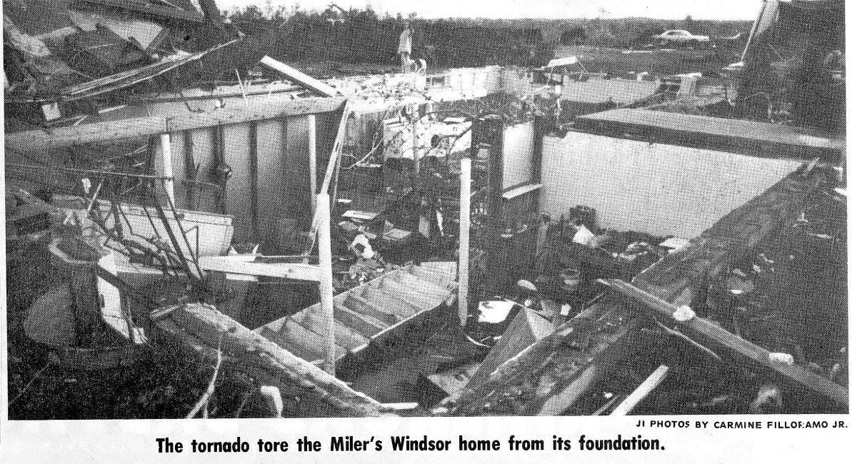
October: the only October tornado I think is a genuine F5 contender is (ironically) the 1979 Windsor Locks, Connecticut tornado. Produced what is likely the most violent damage documented in New England. Numerous homes swept away, trees and low-lying shrubbery shredded and debarked, grass scoured to bare soil, and a 60-ton airplane carried 50 meters and snapped into three pieces.