jiharris0220
Member
Didn’t debris from that tornado reach 60k feet?El Reno/Piedmont from 5/24/2011. Got up well past 40k feet.
Follow along with the video below to see how to install our site as a web app on your home screen.
Note: This feature may not be available in some browsers.
Didn’t debris from that tornado reach 60k feet?El Reno/Piedmont from 5/24/2011. Got up well past 40k feet.
Obviously biased since I live in SoCal, but this event has always fascinated me. I believe it was Tim Marshall who surveyed the tornado and ultimately gave it its 120MPH EF2 rating, based on the semi and railcars. The semi driver was badly injured from what I remember, firefighters had to extract him from the cab w/ the 'jaws of life' and the freeway was shut down for hours. Thankfully he survived the ordeal.

")
I'm now pretty certain that it's a version of this photograph from the July 1919 Monthly Weather Review reproduced at a different quality level, flipped, cropped and possibly retouched, or alternatively one of two photographs taken at nearly the same time.I've seen this photo labeled as the 5/14/13 Seward, NE F4 before but I have no idea if that's accurate.


Nice find! Sure does look like a match. Regarding there being no tornadoes near Solomon, one thing I've noticed (as I'm sure you have, too) is that old-timey sources are often.. less than precise when it comes to naming locations. In this specific case, Solomon might just be shorthand for the Solomon River Valley, which is a much larger area that was visited by several notable tornadoes in that period (most notably in 1903 and 1905). 'Course, it could also be a tornado that was never officially documented, which is the easier (and more frustrating) answer. Wouldn't hurt to comb through some old newspapers from the era.I'm now pretty certain that it's a version of this photograph from the July 1919 Monthly Weather Review reproduced at a different quality level, flipped, cropped and possibly retouched, or alternatively one of two photographs taken at nearly the same time.
View attachment 27656
If I flip the page above and do a rough crop to the size of the original photograph I posted you can see they're very similar - and I think it's too similar to be a coincidence considering the paucity of tornado photos in the era, let alone a somewhat tilty one posed in front of a windmill.
View attachment 27658 View attachment 27659
Trouble is that caption is all there is in the MWR, it doesn't even give a year unlike some of the other tornado photographs with the same article. There apparently wasn't a significant tornado near Solomon in the 1910s or 00s though.
I would be very interested to see this - if that’s the case, Greenfield probably comfortably sits at a 185 MPH EF4 imo.Hey locomusic01, I recall when you were doing research for your 5/31/1985 article, your pretty much ended the misconception that the Niles-Wheatland F5 didn’t produce scouring and debarking. I remember in particular you found a photo from Niles, I believe, that showed a narrow swath of intense grass scouring in a residential area. It was a color photo taken from the ground, but I think it had text or a watermark on it, and you didn’t use it for your article. Do you still have that photo, or any others that show extreme vegetation damage from the Niles-Wheatland tornado?


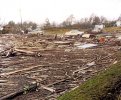
There isn't a ton of clear, unambiguous evidence available that shows significant scouring unfortunately, although numerous reports + eyewitnesses confirm that it happened. I think this is probably the photo you're talking about, which was taken within the Streak of Doom™ in Shadow Ridge:Hey locomusic01, I recall when you were doing research for your 5/31/1985 article, your pretty much ended the misconception that the Niles-Wheatland F5 didn’t produce scouring and debarking. I remember in particular you found a photo from Niles, I believe, that showed a narrow swath of intense grass scouring in a residential area. It was a color photo taken from the ground, but I think it had text or a watermark on it, and you didn’t use it for your article. Do you still have that photo, or any others that show extreme vegetation damage from the Niles-Wheatland tornado?


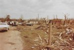
There isn't a ton of clear, unambiguous evidence available that shows significant scouring unfortunately, although numerous reports + eyewitnesses confirm that it happened. I think this is probably the photo you're talking about, which was taken within the Streak of Doom™ in Shadow Ridge:
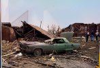
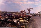
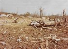
Fairly pronounced scouring also occurred on the east side of Stillwagon Rd., although it looks a bit subdued in photos:
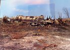
Same area but zoomed + looking WNW (the swath of scouring starts near bottom right):
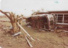
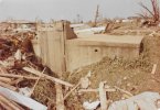
Some scouring also occurred in Wheatland, but I don't think any of my ground-level photos show it very well. You can sorta see it in some of the aerial shots, particularly near the Sawhill plant (the huge warehouse-looking building):
In Wheatland, one of the reasons you can't really see much scouring in ground-level pictures is because of the sheer amount of debris covering the scoured area. Like, this was taken just south of the tracks looking toward Sawhill, and besides the railbed you can't even see the ground, much less identify any scouring.
Ditto w/these:
Kinda the same problem with the aerial videos, except the quality's poor enough that you wouldn't be able to make out much detail anyway:
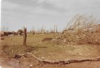
This is probably the best ground-level shot I could find of possible scouring, but it's still kinda questionable, and it was also taken a little outside of the "main" scoured area.
Found a few others I forgot about. There was some ground scouring around Deer Path Village (like ~2mi east of Wheatland), which seems to be visible here although the quality sucks:Thank you so much! The first photo is the one I was thinking of. Incredible stuff!


The Lordstown area contextual damage is quite impressive. I also recall seeing a few pics from the Newton Falls area that appear to show some partial debarking too.Found a few others I forgot about. There was some ground scouring around Deer Path Village (like ~2mi east of Wheatland), which seems to be visible here although the quality sucks:
Going from memory so don't quote me on this, but I think this was one of the homes destroyed in that development:
Also some minor scouring around Lordstown near where the first fatality occurred:
Pretty significant tree damage in that area as well, although the only photo I have from ground level is a newspaper clipping:
You can also see some random debarking & denuding in other photos, but nothing extreme (first two are from Wheatland, third is from near Greenfield):
There isn't a ton of clear, unambiguous evidence available that shows significant scouring unfortunately, although numerous reports + eyewitnesses confirm that it happened. I think this is probably the photo you're talking about, which was taken within the Streak of Doom™ in Shadow Ridge:
Fairly pronounced scouring also occurred on the east side of Stillwagon Rd., although it looks a bit subdued in photos:
Same area but zoomed + looking WNW (the swath of scouring starts near bottom right):
Some scouring also occurred in Wheatland, but I don't think any of my ground-level photos show it very well. You can sorta see it in some of the aerial shots, particularly near the Sawhill plant (the huge warehouse-looking building):
In Wheatland, one of the reasons you can't really see much scouring in ground-level pictures is because of the sheer amount of debris covering the scoured area. Like, this was taken just south of the tracks looking toward Sawhill, and besides the railbed you can't even see the ground, much less identify any scouring.
Ditto w/these:
Kinda the same problem with the aerial videos, except the quality's poor enough that you wouldn't be able to make out much detail anyway:
This is probably the best ground-level shot I could find of possible scouring, but it's still kinda questionable, and it was also taken a little outside of the "main" scoured area.
I remember there were supposedly photos of the Moshannon tornado, and even a video of the Atlantic or Albion tornado that you had heard about, but were unable to actually get ahold of. It’d be incredible if something like that turned up. Probably unlikely, but one can hope.By the way, since we're briefly on the topic of 5/31/85, I've recently heard from a few local media outlets who are planning projects for the 40th anniversary next year. Obviously super early in the process, but I'm hopeful I can get them to use their resources to come up with photos + videos I wasn't able to get myself. Ironically, one of them is a TV station I contacted back when I was researching my article and they flat-out refused to give me anything they had archived from the event. Go figure lol
The best ground scouring pic from Guin (the one with the flipped car) is quite similar to the first one from Niles above. Both scoured the ground down to bare soil in just seconds, which is incredible. Smithville did the same.The other issue here is that a narrow core in a fast-moving tornado doesn't leave much room for much ground scouring.
Guin has a similar issue, it's F5 core was less than 100 yards while going through the town so it's easy to miss it if you don't know where to look, especially from the ground. Also, the sheer amount of debris covering the ground in Guin inhibits easy viewing of scouring.
Oh yeah, I'm having trouble finding the ground view right now but in this aerial (just east of the Mahoning River in Newton Falls) you can see a tree in the top left corner that's still standing but totally stripped. Just below it, there's an uprooted tree next to the white car that's partially debarked in the ground shot. IIRC a couple of smaller trees and bushes in the background of that photo are also debarked and denuded to varying degrees.The Lordstown area contextual damage is quite impressive. I also recall seeing a few pics from the Newton Falls area that appear to show some partial debarking too.

The best ground scouring pic from Guin (the one with the flipped car) is quite similar to the first one from Niles above. Both scoured the ground down to bare soil in just seconds, which is incredible. Smithville did the same.


Yeah, the video was from SW of Albion (probably pretty close to where the tornado was at peak intensity, actually) and that's definitely one of the first things I'm going to point them to. Maybe knowing the video will be on TV will be the motivation they need to actually follow through and turn it over. Can't hurt, anyway. There are also aerial survey videos of several tornadoes out there that I couldn't get my hands on, among other things.I remember there were supposedly photos of the Moshannon tornado, and even a video of the Atlantic or Albion tornado that you had heard about, but were unable to actually get ahold of. It’d be incredible if something like that turned up. Probably unlikely, but one can hope.