Juliett Bravo Kilo
Member
Well it's official; a tornado has achieved supersonic speeds lol

Follow along with the video below to see how to install our site as a web app on your home screen.
Note: This feature may not be available in some browsers.
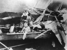
thanks. I thought the last one was West Frankfort, just wondering whether its Peabody Mine #18, peabody mine #19 or Orient mine number 2. Considering the destruction at Peabody Mine #18 I think we can safely rule that out, Orient Mine #2 reportedly had a tipple rolled so it is most likely Peabody Mine #19 which suffered the least.The first is the Chicago & Eastern Illinois Railroad in Griffin, second is De Soto (De Soto School is visible in the background), third is Murphysboro, fifth appears to be the mine at West Frankfort. I don't recognize the fourth one off-hand, but at a guess it looks like it could maybe be this neighborhood in Murphysboro?

I think I've posted them before, but I've got a handful of really high-quality (for the time period) aerials from Murphysboro taken by the Army Air Corps:thanks. I thought the last one was West Frankfort, just wondering whether its Peabody Mine #18, peabody mine #19 or Orient mine number 2. Considering the destruction at Peabody Mine #18 I think we can safely rule that out, Orient Mine #2 reportedly had a tipple rolled so it is most likely Peabody Mine #19 which suffered the least.
That aerial of Murphysboro is new! Thanks been trying to collect Tri-state images.


It almost seems unfair to compare other extremely violent tornadoes to this because this is just so outlandish.In my mind, they're both among the small group of tornadoes that are basically as violent as it gets. At a certain point the damage is so extreme that you can reasonably justify rating them in almost any order (as long as Jarrell is at the top of the list).
If I were forced to choose I'd probably say Bridge Creek, though. The combination of scouring + tree damage + vehicle damage is insane (including multiple confirmable instances of vehicles being thrown > 1 mile). Like.. there were parts of multiple cars and trucks in this little windbreak alone, and you have to look pretty hard to even identify anything that's vaguely recognizable as belonging to a vehicle.
(I know I've shared most of these here and/or in my article already, but they never fail to blow me away.)


A bunch of random vehicles in a chewed-up field, including some that've been stripped to nothing more than the frame/chassis:

Obviously one of the classic images of the event:

More assorted vehicle parts:


Thanks, if you find the locations of them could you get back to me please! Also there is this one which I have no clue where it is.Exceeded the image limit lol. Anyway, apparently didn't label these two so I'll have to see if I can find the locations:
If it's any consolation, your work in general but especially 5/31/1985 has been absolutely superb, probably invaluable, and I can't tell you how much I've enjoyed it.I feel your pain lol. I don't have much of a temper, but that's the kind of thing that drives me crazy.
LMAO
It looks like that CMU wall began mostly below grade and the tornado lifted it up on top of the floor. Amazing!
Tornado Location | Tornado Date | Official Path Length | Grazulis' Path Length |
Abilene, TX | 03/27/14 | 1.4 mi | N/A |
Garland, TX | 05/08/27 | 0.9 mi | 1 mi |
Clyde, TX | 04/28/50 | 1.3 mi | 6 mi |
Olney, TX | 05/18/51 | 2 mi | 6 mi |
WaKeeney, KS | 06/26/51 | 0.8 mi | 1 mi |
Fayetteville, TN* | 02/29/52 | 2 mi | 2 mi |
Newbern, TN | 03/21/52 | 2 mi | 30 mi |
Hickory Ridge, AR | 03/21/52 | 0.1 mi | 65 mi |
Helotes, TX* | 04/28/53 | 1 mi | 10 mi |
Warner Robins, GA | 04/30/53 | 1 mi | N/A |
Yantley, AL | 05/01/53 | 0.1 mi | 10 mi |
Adair, IA | 06/27/53 | 0.1 mi | 10 mi |
Dooville, IN* | 03/06/56 | 1.9 mi | 3.5 mi |
Pleasanton, NE | 06/06/56 | 2 mi | 5 mi |
Gans, OK | 01/22/57 | 0.1 mi | 5 mi |
Pembroke, NC* | 04/08/57 | 0.8 mi | 1 mi |
Bereah, FL* | 04/15/58 | 0.1 mi | 5 mi |
Galveston, TX | 09/11/61 | 1 mi | 1 mi |
Rochester, MN | 09/15/62 | 0.5 mi | 1 mi |
Larose, LA | 10/03/64 | 1.5 mi | 2 mi |
Fort Dodge, IA | 06/08/67 | 2 mi | 10 mi |
Watonga, OK* | 06/10/67 | 0.1 mi | 5 mi |
Greenwood, AR | 04/19/68 | 2 mi | 2 mi |
Oil Trough, AR | 05/15/68 | 0.3 mi | 5 mi |
Buffalo, SD | 07/07/69 | 1.8 mi | 2 mi |
Ninety Six, SC* | 12/13/73 | 1 mi | 0.1 mi |
Ladora, IA | 08/12/74 | 2 mi | 2 mi |
Fort Dodge, IA | 05/04/77 | 2 mi | 2 mi |
West Bend, WI | 04/03/81 | 1.8 mi | 2 mi |
Andover, MN | 07/03/83 | 1 mi | 1 mi |
Dodgeville, WI* | 07/03/83 | 0.5mi | 0.5mi |
Colonial Heights, VA | 08/06/93 | 1 mi | 12 mi |
Marion, SC* | 11/07/95 | 0.7mi | 0.7mi |
Medina, ND | 08/11/2002 | 1 mi | N/A |
Harper, KS | 05/12/2004 | 1.2 mi | N/A |
This is the first I'm hearing of the Harper F4 and WHAT.Saw a few others discussing what the shortest path length is for a violent tornado. Here's what I was able to dig up:
WARNING: SPREADSHEET INBOUND
There are several things to note about this table. As you can see, a lot of obvious path length errors. The asterisked tornadoes* are rated below F4 intensity by Grazulis. He makes a special note about WaKeeney, mentioning it "was among the briefest touchdowns of any confirmed F4 tornado". All of these events except Adair (F5) are officially rated F4.
So, what is the answer to the question "What violent tornado has the shortest path length?" As far as F5 tornadoes go, I think most on this forum would agree with me that the 2004 Harper tornado was a shoulda-been F5, which would make it have the shortest path length of any F5 tornado.
As for what F4 tornado has the shortest path length, things get a bit complicated. If one is to assume that all the path lengths within the limits of rounding are correct (and only consider tornadoes rated F4 by both the NCEI and Grazulis), then the 1962 Rochester tornado has the shortest path length at half a mile. One could also agree it was the 1951 WaKeeney tornado given the special note Grazulis makes about it. By far the biggest oddity (IMO) is the 1973 Ninety Six tornado. Two tornadoes struck the city that day, with both of the fatalities being caused by the shorter tracked tornado. Grazulis is the one who lists the path length of 0.1 miles, not the NCEI, though he also downgrades its intensity to F3. It should not be confused with the (official) F3 that tracked for 18 miles and hit the city on the same day. And this short paragraph just scratches the surface with the confusion... but the bottom line is, there is no definitive answer.
No. Let's run the list.
Bold - almost certainly accurate (or at least indisputably tracked over 75 miles)
Italics - almost certainly inaccurate
Normal - not sure
Hazlehurst, MS F4 (Mar 29, 1976, 126.5 miles) - Grazulis thinks it may have been up to six tornadoes
Ulysses, KS F2 (May 18, 1977, 117.2 miles) - Grazulis lists a 30 mile F2 as 'the first part of a skipping path'
Wadena, MN F2 (Aug 26, 1977, 110.4 miles) - Grazulis list three F2s, two of which 'skipped' themselves and only total 49 miles, clearly a family
Muscatine, IA F0 (Apr 4, 1981, 103.5 miles) - there are several seperate tornadoes in Storm Data, including a 'mostly skipping' 50 mile. Goodness knows how they all got combined.
Delta, IA F4 (Jun 7, 1984, 134 miles) - Grazulis thinks this one's at least three tornadoes.
Lawrence, NE F4 (Mar 13, 1990, 131 miles) - probably a family. Storm Data says it was likely at least two tornadoes and apparently Grazulis thinks so too. I'e never seen any suggestions for where the breaks might be though.
Albion, IL F4 (June 1, 1990, 106 miles) - I only have the 1880-1989 version of SigTor so I don't know what Grazulis thinks of this one,though I've never seen it questioned elsewhere. EDIT: the Storm Data entry mentions 'lifting' crossing the Wabash River and 'skipping' in Indiana as far as Hazleton
Brandon, MS F4 (Nov 22, 1992, 126 miles) - I'm reluctant to judge the exact path without being able to get the Landsat settings that were on the old viewer, but highly likely it was a family. The offical path has several jinks in it that don't really make sense.
Wilson, NC F3 (Nov 23, 1992, 160 miles) - in Storm Data, the surveyors genuinely think this one's continuous. As quoted on Wikipedia, Grazulis think this one was a family.
Martinsville-Indianapolis, IN F3 (Sep 20, 2002, 112 miles) - this one's definitely a family. The Storm Data entry for Blackford County says "NWS officials reported the tornado touched down and lifted numerous times along the path" but the one for Delaware County claims it was continuous. I'm quite doubtful of this one.
Atkins-Clinton, AR EF4 (Feb 5, 2008, 123.5 miles) - apparently this one was confirmed aerially.
Yazoo City, MS EF4 (Apr 24, 2010, 149 miles) - this one appears to be continuous
Hackleburg-Phil Campbell, AL EF5 (Apr 27, 2011, 132 miles) - according to TT it was 103 miles, which matches with how it's plotted in the DAT.
Cordova, AL EF4 (Apr 27, 2011, 127.8 miles) - TT hasn't done a summary yet, but they've written "Cordova EF3/EF4 tornado" which makes me think they think it's either two tornadoes or wasn't an EF4.
Enterprise, MS EF4 (Apr 27, 2011, 122 miles) - someone who's not too cheap to pay for the article will know.
Mayfield, KY EF4/EF5 (Dec 10, 2021, 166.4 miles) - confirmed
Dresden, TN EF3/EF4 (Dec 10, 2021, 122.9 miles) - confirmed
I pay for a Tornado Talk membership and I don’t recall that Enterprise was considered to be more than one tornado.Whilst we're on the subject of path lengths, a while ago @Lake Martin EF4 posted a list of very long tracked tornadoes in the official database since 1975. I said in the Global Edition thread that I'm sceptical of very long tracks, even though I think there's something slightly thrilling about a really big number. I've removed all the ones that were less than 100 miles and inserted my own comments.
I do hamper myself by being too cheap to subscribe to anything, which restricts me bit because much of the best info on some events is on Tornado Talk behind a paywall. But that's obviously my own fault.
Overall that leaves at most eight of the original seventeen that I'd be comfortable with. We've had some very remarkable events since 2008 that I think give us a good gauge of what ultra-long trackers are like, and the fact that they're very rare.
This is the first I'm hearing of the Harper F4 and WHAT.
I looked at the photos on an NWS page and while I'm no damage expert... you could not tell there was a house ever there. If the photos were labeled correctly, it looks like a Grove of debarked trees and nothing else. Not to mention the level of scouring evident.
Nothing particularly impressive/high-quality tbh. I'd have to go through all my photos again, but off the top of my head, these are probably the best I have:Thanks, if you find the locations of them could you get back to me please! Also there is this one which I have no clue where it is.
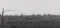
Have you come across any images of tree damage? Since the descriptions of them sound extreme I just wish I could find photographic evidence. The only one I have is a poor quality one near De soto.


Thanks man, I really appreciate that!If it's any consolation, your work in general but especially 5/31/1985 has been absolutely superb, probably invaluable, and I can't tell you how much I've enjoyed it.
Hey, it's good to see you around a bit more again! I stared at that one for quite a while thinking the same thing; it's hard to work out exactly what happened, but it sure looks impressive. IIRC either three or four people were killed there.It looks like that CMU wall began mostly below grade and the tornado lifted it up on top of the floor. Amazing!
This pic from Murphysboro you can see some tree damage, also ground scouring if you colorize it:Nothing particularly impressive/high-quality tbh. I'd have to go through all my photos again, but off the top of my head, these are probably the best I have:
Incidentally, they're from opposite ends of the path (first is Perry County, MO and the other two are Princeton, IN). The third one is part of a large grove of trees that was almost entirely snapped and/or uprooted; I've read that some were also debarked but I haven't actually seen it.
Thanks man, I really appreciate that!
Hey, it's good to see you around a bit more again! I stared at that one for quite a while thinking the same thing; it's hard to work out exactly what happened, but it sure looks impressive. IIRC either three or four people were killed there.