
SpotlightForRareTornadoes
Member
11 years of El Reno
The Tragic Fate of Twistex -
The Tragic Fate of Twistex -
Last edited:
Follow along with the video below to see how to install our site as a web app on your home screen.
Note: This feature may not be available in some browsers.


I think Xenia might’ve gotten an EF5 rating nowadays, if of course we’re factoring in contextual damage that was there to support the sheer number of homes slabbed with no debris in sight. But since those homes were small and probably connected to their foundations with a few nails and some scotch tape, I kind of find it hard for a surveyor to find true EF5 damage in Xenia, at least by todays standards. I think Moore ‘13 also kind of exposed how strict the scale really is with only 9 homes earning an EF5 rating, despite it being one of the most violent tornadoes in modern history. The damage in the Plaza Towers area (which in my opinion is the most complete wipeout of a residential area you will ever see) getting hit with an EF4 rating despite the overwhelming evidence of EF5 strength was a bit of a clue to just how strict the scale is, along with the Orr Family Farm area.Yea, Xenia is a clear cut case low end F5 tornado that definitely wouldn’t get an Ef5 rating today, since you know, apparently a tornado has to do Jarrell or Bridge Creek level damage in order to reach that mark.
The 70s were an interesting decade regarding tornado ratings as any house regardless of construction were rated a 5 as long as debris has been swept. I can’t help but wonder what Ted Fujita himself would think of the Ef scale rating methodology today.
@pohnpei For sheer violence I would concur that Bridge Creek ‘99, Joplin/El Reno ‘11, and Moore ‘13 were—alongside Jarrell, Parkersburg, Smithville, and Vilonia—the most violent of note in modern times to be reliably documented. If one were to extend criteria the list would obviously be notably longer, including second-tier worthies such as Andover, Hackleburg, and Philadelphia. Honorable mention would go to events such as Loyal Valley, Harper, Westminster, and Greensburg, for instance, along with Chickasha/Goldsby. Bakersfield Valley, Stratton, and Chandler are insufficiently documented but likely to be among the most violent as well.It's very hard to measure "the worst". Like if we just talking about the shear number of trees completely debarked, regardless of species, then Bridge Creek, Moore 13 and El Reno 11 were way way more than Harper or Branenburg. All three tornados literary completely debarkes any sort of trees from beginning to end and I can post each of them at least 50 pics showing trees complete debarked. And amounts of trees debarked by Joplin was incredible. I would normally saved impressive debarking pics of other tornados but I never save Joplin's debarking pics in particular because there were just too many.
Also, if we are just talking about the overall numbers of very high end vehicle damages, then two F/EF5 tornados went Moore really stick out. I have a collection of high end vehicle damage made by Andover 1991 but I would never do one for Moore because there were too many of them.
"Nah, it was definitely a high-end EF3."I think Xenia might’ve gotten an EF5 rating nowadays
11 years ago today.
A lot of it was just seeing what TG said. A bit trusting maybe, but I don't have any alternative sources. Lots and lots of scrolling through a 700-page PDF to find the right storm. And interpreting the Storm Data entries for more recent ones.Great work, very very interesting and I’d imagine that took quite a bit of time to discern all of that considering past data is very unreliable at times (@ the 170 mile F1)
Great job! I'm fascinated by very long-track tornadoes and I've always wanted to dig into investigating the most extreme paths further. 'Course, as you said, it's often hard to know for certain even with a lot of research, but you can at least make some educated guesses.
Incidentally, you mentioned the Berlin, NE tornado from the 1913 Easter Sunday Outbreak - that's one of the events I've been thinking about tackling next, and I've been working on mapping the tornadoes out via plat maps and whatnot. My path length for Berlin is slightly under 67 miles, although that's including a bit of interpretation on the assumption that it didn't literally touch down/dissipate exactly at the first and last damage points. The distance between the first/last points themselves is like 65.5 miles (about 35 miles in NE and 30 miles in IA), and I'm reasonably confident the path is continuous based on the points I've mapped so far.
Re: Worcester, the 46 mile figure includes the first section beginning near the Quabbin Reservoir west of Petersham, but this seems to have been a separate tornado based on my research. A number of accounts described the tornado "bouncing" into the air after crossing a pond south of Petersham whose name I've forgotten (Connor's Pond maybe?), at which point it touched down again about a mile to the south. FWIW, my path length is 38.1 miles:


Yeah, there's zero doubt the damage in Iowa was tornadic. In fact, some of it was arguably more intense (although less widespread) than in Nebraska, not to mention the fatalities and near-fatal injuries. Two members of the Lambert family were killed and another was gravely hurt in the Berlin F4 at this one property in "Elm Grove" (Mills Co, IA), for instance:The 1913 event is a fascinating one. Although still relatively short, Condra and Loveland's AGS article is one of the best descriptions of a tornado outbreak from that era, including for example their judgement that the Omaha tornado was less intense than the Berlin and Yutan ones. Interestingly their MWR article says the Des Moines meteorologist claimed only straight line winds occurred in Iowa (seems doubtful). I do wonder how much more extensive the outbreak might have been, they mention storms further west and I could swear I once saw a mention of ones in Kansas.


Yeah, a lot of the maps for older events are pretty imprecise, even if they're contemporary. There's a bit of ambiguity in the accounts I used as to exactly where the damage stopped and started again, but it's a matter of like a few hundred yards one way or the other. All of the accounts are clear that it lifted and touched down again before reaching Barre, not after — which is also supported by the fact that two people were killed about a mile due north of Barre, and we also have photos of damage (and the tornado itself) near Rutland in the "skipping" part of the path shown there.Your Worcester map shows the possible break further west than the map from Penn et al 1955 in BAMS, which I think might be where the official path length is derived from:
View attachment 28348
Absolutely, that's a big part of what makes it so complicated. For instance, I've talked a bit before about a section of the New Richmond path east of Burkhardt where it seems like there could've been a break, but based on various eyewitness accounts, it sounds more like a failed occlusion to me. The tornado dramatically weakened/contracted and the condensation funnel seemed to start "lifting" as it recurved northward, but apparently there was continuous tree damage on the ground (as best as I can tell), and the fact that the tornado immediately restrengthened and grew into a mile-wide monster within a few minutes also suggests the circulation probably never lifted entirely.That said I'm not sure every instance of a tornado 'skipping' or even 'lifting' is a tornado family. I suspect in a clear rural area a tornado, especially aifnarrow, may appear to cause damage only when it hits more vulnerable features unless it is strong enough to disturb grass etcs. I have a couple of satellite studies that show the damage in forests can be patchy. These might be called 'skipping'. As for lifting, we have footage of the Henryville tornado's condensation funnel completely dissipating for about a minute then reforming, and Wilhelm's footage shows something similar with Tuscaloosa, where only a wall cloud is visible. Long-track tornadoes weakening down to E/F0 and re-strengthening otherwise doesn't seem to be that common (???). I'd say the vast majority of 'skips' and 'lifts' are path breaks, but there might be an occasional exception.

@A Guy Interestingly, a reanalysis of the 1913 outbreak sequence has been tentatively published, based in part on this (more links are found here). Anyway, the data confirm that 23 March alone produced many more tornadoes than Thomas P. Grazulis lists, a considerable proportion of which were likely F2+, including undocumented members of the known F3-F4 families along and near the NE/IA border. The Yutan, Omaha, and Council Bluffs F4s apparently tracked considerably longer than listed or reformed into new tornadoes, producing additional damage. About 10 more tornadoes—none noted by Thomas P. Grazulis!—were separately documented across portions of KS, IA, and NE, based on descriptions and maps. Here is an overview of the event, extracted from the third link:The 1913 event is a fascinating one. Although still relatively short, Condra and Loveland's AGS article is one of the best descriptions of a tornado outbreak from that era, including for example their judgement that the Omaha tornado was less intense than the Berlin and Yutan ones. Interestingly their MWR article says the Des Moines meteorologist claimed only straight line winds occurred in Iowa (seems doubtful). I do wonder how much more extensive the outbreak might have been, they mention storms further west and I could swear I once saw a mention of ones in Kansas.

The NWS (Donald Burgess) and Thomas P. Grazulis (The Tornado, 2001) seem to think that the longest single member of the Woodward family tracked ~98 mi from just northwest of Canadian, TX, to a point just west of Alva, OK (the endpoint is a bit uncertain, but the tornado apparently dissipated a short distance afterward and reformed in Barber Co., KS). The reference to an additional five or six tornadoes in Grazulis (1993) was put somewhat sloppily but apparently covers the entire path rather than OK. Apparently at least four separate tornadoes formed in TX prior to the main event.There is an interesting conundrum that comes from this. Between Grazulis' opinions and other sources, unless I am missing one there's only a very small number of candidates for 100 milers between 1925 and 2008. Woodward (which could be significantly under), Hazelhurst ("almost continuous") and Jasper (but I can only see a portion of it on the satellite image). Whereas there's been seven from 2008 to 2021. Makes me wonder if there are a couple more genuine ones in that long period.
This photograph was posted by @Juliett Bravo Kilo earlier in the thread - really the only photo of damage I've seen from the Murphy tornado:Murphy, NC is another pet favorite of mine. Allegedly did remarkable tree damage - is also totally obscure.
The second to last photo is one of the few clear-cut photos of debarking I've seen from Niles-Wheatland. I'm sure it produced more widespread debarking than what was photographed, but the only other photo of such that stands out to me is the one taken next to the hotel in Wheatland.A few new photos from Niles taken by Jack Hales (former NSSFC/SPC lead forecaster) around the Niles Park Plaza area:
This is the house just west of the plaza in which an older husband and wife were killed:
Not sure exactly where this one was taken:


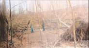
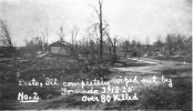
Part 2. I can do part 3 if anyone wants.Found some new tri-state images that I don't think have been posted here yet. Starting with rural Missouri areas.
View attachment 28352
View attachment 28353
View attachment 28354
View attachment 28355
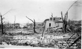
This one being significant, another angle of Claus Stueve's home which has it's stone foundation visible.
View attachment 28356
View attachment 28357
View attachment 28358
View attachment 28359
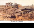
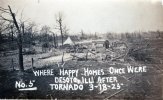
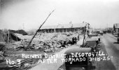
Now some ones of Murphysboro.
View attachment 28360
View attachment 28361


 Significant Tornado Events _ Page 538 _ TalkWeather and 11 more pages - Personal - Microso...png") The 1980 Grand Island Outbreak is the craziest and most devious tornado outbreak ever for 44 years.
The 1980 Grand Island Outbreak is the craziest and most devious tornado outbreak ever for 44 years. ")
That second photo caught my attention. It's one of the few photos I've seen from the Tri-State tornado that show clear cut debarking. From what I hear, many trees in IL are of a particularly durable species of hardwood that is nearly impossible to completely debark (the 11/17/2013 Washington tornado managed to completely debark few, if any trees despite moving through town at high end EF4/marginal EF5 intensity) and yet that tree appears to be almost completely debarked. Very impressive.Part 2. I can do part 3 if anyone wants.
View attachment 28363
View attachment 28364
View attachment 28365
The shoe factory.
View attachment 28367
View attachment 28368
View attachment 28369
View attachment 28370
Logan School
View attachment 28371
Part of the high school
View attachment 28372
Longfellow school high res
View attachment 28373
I can see you are as disorganized with your browser tabs as me.View attachment 28400The 1980 Grand Island Outbreak is the craziest and most devious tornado outbreak ever for 44 years.
Most of the tornadoes in Grand Island were so unpredictable because they were mostly anticyclonic. Since tornadoes are not used to spinning anticyclonic for long periods of time, especially when they are slow-moving and weak, they tend to have crazy paths like these. The F4 had a less loopy path because it was strong enough to prevent itself from being absorbed in its own circulation. Still, the twister moved westward in a semi-cycloidal path, killing 3 people.
")
lolThat second photo caught my attention. It's one of the few photos I've seen from the Tri-State tornado that show clear cut debarking. From what I hear, many trees in IL are of a particularly durable species of hardwood that is nearly impossible to completely debark (the 11/17/2013 Washington tornado managed to completely debark few, if any trees despite moving through town at high end EF4/marginal EF5 intensity) and yet that tree appears to be almost completely debarked. Very impressive.
I can see you are as disorganized with your browser tabs as me.

