Alright, write-up incoming:
In the afternoon through evening hours of November 7, 2025, two extremely violent tornadoes would be spawned by a cyclic supercell in the state of Parana, Brazil.
Rio F4 (Retiro-Rio Bonito do Iguacu-Lagoa Seca)
This large tornado first touched down west of Rio das Cobras ("River of Snakes"), where damage that I've marked as "possible" is visible on Sentinel-2 L2A satellite imagery taken on November 10. It sped to the east, inflicting relatively minor damage to trees while appearing to wobble slightly. A short distance east the tornado produced sporadic damage (possible multi-vortex) as it dipped south, before moving back to the east. Tree dmaage is visible from this point onwards on Sentinel-2 imagery I've overlayed. As the tornado entered Rio Bonito it inflicted heavy damage to a grove of trees:
View attachment 49041
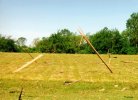
East of here the tornado crossed Highway 158, where I geolocated a rather chaotic video of damaged structures with the tornado in the background. It appears to have ran parallel to this highway before turning east into town, where it almost immediately reached F3+ intensity. A home on the town's west side was damaged with debris craters being observed in a field a very short distance southwest. An elementary was hit along Avenue XV de Novembro, which is where I think it began to gain in intensity. It almost certainly reached F4 intensity along R. 7 de Novembre, where a home was swept off its foundation and two large concrete garages suffered damage. I could write a whole essay about what happened just in town, but to put it simply, several points of F4 damage are noted.
I do not think it reached F5 intensity in town.
View attachment 49043
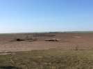
After leaving town is where things get interesting - I note significant-to-violent tree damage spanning a large swath for a considerable distance east of town. In this swath is where I found what I think is likely some of the most impressive damage from this tornado if it was actually tornadic:
View attachment 49044
This grove of trees was utterly obliterated, and on October 23 imagery it appears to have been untouched. I'm a little skeptical due to the thin line of trees on the northern edge, but it's certainly extremely violent damage assuming it's tornadic. I won't bore you with all the details further east but basically it just munched on trees. Along the end of it's path the tornado appears to have turned north (south of Lagoa Seca), which signifies the occlusion process. Due to the supercell being upside down, I was expecting it to have occluded south, but you never know.
View attachment 49045
Guarapuava F4 (Lagao Seca-Nova-Geracao)
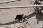
As the Rio Bonito do Iguacu tornado occluded to the north, a second, likely-stronger tornado touched down southwest of Campo Real. It shot eastward, where east of a road the first signs of tornadic damage became evident on satellite. Scouring of the cultivated earth occurred here, as well as significant tree damage in a flared fashion.
As it continued east, a visible scar became noticeable to the northeast of Fazenda Cachoerinha. This continued through the River Jordao area, where more tree damage was observed. South of PCH Tres Capoes Novo the tornado obliterated a tree grove, and east of that location the tornado became violent, scouring the ground and ripping apart both Auracacia (I butchered that) and Eucalyptus trees:
View attachment 49046
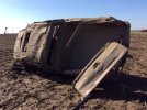
Just to the east of this location was some of the most intense damage documented from either tornado - an extremely well-built, recently-constructed (2019-2021) mansion was partially wiped away, with the forest to the east being eviscerated. This is the most convincing damage to suggest F5 from
either tornado, and while I can't share the construction details due to a PREVOTs/SIMEPAR conflict I'll say that it was extremely well-built:
View attachment 49047
The tornado wobbled slightly as it got ready to cross over the River Jordao a second time, producing intense tree damage as it moved over the water and back onto land. To the east the tornado entered the Nova Geracao community, where a metal container was deposited and heavy tree damage took place. It jogged northeast from this location, violently damaging a grove of trees and leaving a visible land scar. The tornado appeared to weaken as it turned eastward and then southward, eventually lifting a short distance east of the last observable satellite damage.
This is a project I've been working on since the day the tornado happened.
Questions regarding damage done by either tornado are welcome, and I can send the .kmz I've been working on if anyone wants it. Planning on writing a much longer write-up once more mansion photos are released. I can shorten this if requested (lmao); I'm not on forums outside of this one and am not completely sure about "wall-of-media" etiquette.

 Screenshot_20251127_144849_Drive.jpg77.8 KB · Views: 1
 Screenshot_20251127_145018_Drive.jpg106.7 KB · Views: 0
 Screenshot_20251127_145342_Drive.jpg61.6 KB · Views: 0
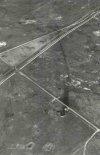 Screenshot_20251127_145411_Drive.jpg118.6 KB · Views: 0
 Screenshot_20251127_144609_Drive.jpg87.2 KB · Views: 0
 Screenshot_20251127_144609_Drive.jpg87.2 KB · Views: 0
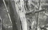 Screenshot_20251127_144849_Drive.jpg77.8 KB · Views: 0
 Screenshot_20251127_145018_Drive.jpg106.7 KB · Views: 0
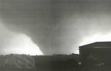 Screenshot_20251127_145342_Drive.jpg61.6 KB · Views: 0
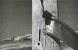 Screenshot_20251127_144609_Drive.jpg87.2 KB · Views: 0