Juliett Bravo Kilo
Member
Higgins:


Follow along with the video below to see how to install our site as a web app on your home screen.
Note: This feature may not be available in some browsers.
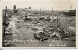
Aerial of WoodwardWoodward:


Here’s a video I’ve never seen before of the Parkersburg IA EF5 tornado from a sheriff in Grundy County (south of Parkersburg).


Good god, that is an absolutely MASSIVE wall cloud and a great inflow tail.


So where did this event occur? I take it somewhere a place you don't often expect tornadoes to form?Today MNStorm, I, and some other discord users discovered a very unique tornado event. On May 31st, 2018, a supercell thunderstorm displayed a very intense velocity couplet, with gate-to-gate shear of around 190 mph. No tornado was ever confirmed, but satellite data suggests there definitely was a tornado present, and it was INTENSE.
Forecast Sounding for the area affected by the supercell thunderstorm shows a classic cold-core tornado setup.
View attachment 5388
Radar Data from KSFX at 21:20 UTC shows the velocity couplet at maximum intensity (190.22 mph GTG shear)
View attachment 5389
Satellite data shows the hail core of the supercell, and clearly a separate swath of damage that was consistent with the location of the mesocycloneView attachment 5390
Up-close view of the scouring swath. There's compelling evidence this tornado was likely capable of EF3+ damage.
View attachment 5391
Near the Craters of the Moon Idaho. This particular tornado was never surveyed by the NWS but a tornado that formed after this one was. The second tornado was given an EF1 rating but it was likely stronger as steel beams were twisted with portions below the surface being moved an inch, vinyl/steel cables were ripped apart and scattered for several yards, a sign was snapped off at the ground, sagebrush were completely ripped out of the ground and several small lava rocks were tossed. One guy did almost reach the damage path from the first tornado but stopped about 1 1/2 miles from it due to bad roads. He saw the track from a distance and noted RFD damage to trees. A weather station 2 miles south of the 1st tornado's path recorded a wind gust of 85 mph which shows the storm had very strong inflow.So where did this event occur? I take it somewhere a place you don't often expect tornadoes to form?

This other picture of Hackleburg is also what the Tri-State tornado looked like in certain parts of its path as a giant cloud moving along the ground. It also helps demonstrate the sense of scale and sheer magnitude of both events (check the houses), based on what people would have seen back then as in 2011:An eyewitness account from Gorham confirms that the Tri-State-Tornado was a literal copy of Hackleburg. That eyewitness was in a restaurant, and it began to rain outside. She decided to leave, and went to open the door, and saw a big dark wall that seemed of smoke, and in front of it white trails that seemed of smoke. The "light billows that seemed of smoke" were describing the wall cloud of the Tri-State-Tornado (notice some light gray billows on the Hackleburg Tornado's mesocyclone, this is most certainly what she was talking about), and the great dark wall that seemed of smoke was most definitely the tornado.
View attachment 5189
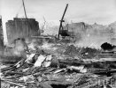
This is in concordance with another eyewitness account from that area, who described seeing a great big dark mass throwing water as the tornado crossed the Mississippi River from Missouri into Illinois, where the damage appears to have peaked in intensity. In this area the ground was deeply scoured, trees completely debarked, and grass well outside of the center of circulation in a gully was also scoured. The damage swath of the 1925 Tornado in Murphysboro was also gigantic and erratic, with entire sections of neighborhoods dissapearing. It appears that the Longview School, the school that was hit in Murphysboro where 33 died, barely avoided sustaining a direct hit from one of the vortexes, evidented by severe damage to 1 part of the building while the rest of the building stayed mostly intact (before the tornado it was one main structure.)
Before 1925
View attachment 5190
After 1925
View attachment 5191
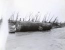
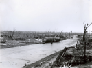
Some of the worst images I could find of the Tri State Tornado below:
Brick Home sheared off at ground level near Griffin
View attachment 5192
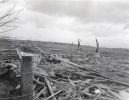
Home annihilated near Crossville with what appears to be debarked vegetation in the background
View attachment 5193
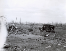
Near the Longview School, brick homes sheared off at ground level (note significant granulation of debris nearby)
View attachment 5194
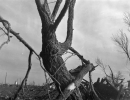
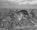
Debarked Tree in an unknown location (likely De Soto)
View attachment 5195

This particular view of the Hackleburg tornado is pretty unreal. I’ve never seen another one quite as menacing as that. And yes, the first time I saw this particular video, I thought, “That is how the Tri-State must’ve looked.”This other picture of Hackleburg is also what the Tri-State tornado looked like in certain parts of its path as a giant cloud moving along the ground. It also helps demonstrate the sense of scale and sheer magnitude of both events (check the houses), based on what people would have seen back then as in 2011:View attachment 5395
The tornadoes that go through Northern Alabama also have a tendency to cross into far southern Tennessee (Lincoln and Franklin County, specifically) before dissipating. The second 1974 Tanner tornado did damage in Franklin and Lincoln TN before lifting and its TN portion is not that far off from 2011 Hackleburg.This particular view of the Hackleburg tornado is pretty unreal. I’ve never seen another one quite as menacing as that. And yes, the first time I saw this particular video, I thought, “That is how the Tri-State must’ve looked.”
That particular area of Alabama must be like a magnet for F/EF5 and 4 tornadoes. There have been so many in that corridor (or very close to it) that have wrought so much destruction.
Both 1974 Tanner F5 tornadoes and the Guin F5 were in that same corridor. The 1920 outbreak saw an F5 follow basically the same exact path as the Hackleburg storm doing the same kind of damage. It formed by Aberdeen MS (near Smithville), entered Alabama just southwest of Hamilton and went right up the Hackleburg/Spruce Pine/Russellville way. Same outbreak also saw an F4 south of Huntsville.
I remember reading the comments on ExtremePlanet (I think in the 1974 v 2011 outbreaks post) and one guy said that his grandmother, who lived in Hatton, was there for both the 1920 outbreak and the 1974 outbreak (close calls both times if she was in Hatton). Anyway, apparently she told him that it was very bad both times but that the 1920 tornadoes were worse than the 1974 were. I do know that the 1920 Hackleburg twin tore up N Alabama. It lifted just a few miles southwest of Hatton (Waco Quarry) so it was close for the grandmother.
Also, there was an F4 in that same corridor (Smithville/Guin/Hackleburg) in 1909 just North of Elkmont in Limestone county.
The famous 1936 Tupelo supercell that spawned the F5, killing so many in that town ended up also putting down an F4 about 9.5 miles northwest of Phil Campbell that raked that same area.
In a 1952 March outbreak an F4 formed on the north side of Bankhead national forest and went through Moulton, Decatur, Mooresville, Madison and Redstone Arsenal before dissipating just southwest of Huntsville.
In the 2008 Super Tuesday outbreak, a supercell formed in Eastern MS and went right over Guin and the William B. Bankhead National Forest before an F4 formed over the edge of the forest before hitting Moulton/Decatur and on up into Limestone county.
So many in that area. 1989 an F4 put down just past William B. Bankhead National Forest (Guin track) and just like in 1974 hit Redstone Arsenal and South Huntsville. (Once the 1975 Guin tornado dissipated, that supercell put down another tornado that hit Redstone Arsenal and Huntsville).
May 1917 an F3 hit New Hope. 1957 a long tracked F3 formed south of Hamilton (exactly where the 1920 and 2011 Hackleburg storms hit).
And many more, I’m sure.
When I read about a tornado in that area I always make a note because I’m amazed at the amount of violent tornados that they get.