• Welcome to TalkWeather!
    We see you lurking around TalkWeather! Take the extra step and join us today to view attachments, see less ads and maybe even join the discussion.
    CLICK TO JOIN TALKWEATHER
  • April 2024 Weather Video of the Month
    Post your nominations now!
Messages
2,235
Reaction score
2,827
Location
Missouri
The crazy thing is that it wasn’t an object though. Dense southern soil just seems to scour in that odd, patchy pattern.

I think you can actually see the scouring taking place in the video you posted. There are several points where there appears to be an “explosion” of dirt that violently spirals around the funnel. I strongly suspect that what we’re seeing there is the ground literally failing and being thrown into the air by extremely intense suction vortices.
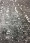
At 4:10 I saw a large brown splotch swirl around the funnel for a bit, pretty crazy. I would love to find a photograph of the 200-foot section of grass that was scoured away at a pasture, leaving only bare soil behind that Grazulis mentioned.

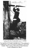
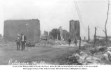
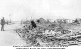
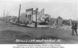
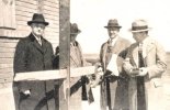
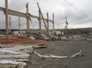
Interesting little note, it was once thought to be a single, long-tracked tornado but in 2013 it was determined to be from a family of 3 tornadoes, the other two being F4s. The first and third were F4, the second was the F5. The 3 fatalities originally attributed to the F5 were actually caused by the first tornado of the family, the first F4 that tracked through Hardin and Wayne counties. This is a photograph of it that is often incorrectly identified as being of the Wayne/Lawrence County F5.


1.jpg

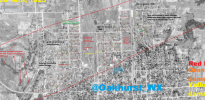
Source: https://www.weather.gov/ohx/19980416 (you'll have to scroll down a bit):
 
Messages
2,235
Reaction score
2,827
Location
Missouri
Murphysboro continued. I've got a ton of Tri-State pics on my computer, perhaps we should start a separate thread for it:
 

Attachments

  • 63.jpg
    63.jpg
    50 KB · Views: 0
  • 64.jpg
    64.jpg
    80.7 KB · Views: 0
  • 66.jpg
    66.jpg
    71.1 KB · Views: 0
  • 67.jpg
    67.jpg
    74.7 KB · Views: 0
  • 65.jpg
    65.jpg
    67.6 KB · Views: 0
  • 73.jpg
    73.jpg
    97.7 KB · Views: 0
  • 74.jpg
    74.jpg
    30.6 KB · Views: 0
  • 75.jpg
    75.jpg
    608.1 KB · Views: 0
Last edited:

pohnpei

Member
Messages
965
Reaction score
1,971
Location
shanghai
Same here, of course there's likely a ton of photographs of it we haven't seen and likely aren't easy to find. I mean, a tornado that's on the ground for nearly 3 hours undoubtedly hits EF5 at some point. I've seen aerial photos of forest, not so much ground level, is there no debarking of trees or annihilation of low-lying vegetation from it?
I also haven't seen violent vegatation damage of Yazoo City EF4 and this tornado actually hit a lot of structures in its radar peak but the damage was no more than low end EF4. Tornado are werid things. They can maintain EF1-2 winds continuesly for one hour and they can also reach EF5 intensity in 10-20 seconds (2016/5/24 DOW)and then disappears quickly(Harper 2004 only lived 5 mins). The longest and widest doesn't mean the strongest. By the way, Bassfield also wasn't strongest as it was widest.
 

MNTornadoGuy

Member
Messages
1,625
Reaction score
2,599
Location
Apple Valley, MN

Austin Dawg

Member
Sustaining Member
Messages
880
Reaction score
1,352
Location
Leander, Texas
Given my interest in Dixie Alley events and the Tri-State Tornado, I felt like posting these clips of the Hackleburg. First off, this video is from a storm chase, the incredible forward speed of the tornado is evident throughout (see how quickly it comes to reaching the videographer):

1.

2. This is a classic video of it, so ghostly how it sounds and how quickly it moves through:

3. 5:20 in this vid is the most notable, the width and scope of this thing:

4. This pic of Hackleburg: View attachment 5126

These videos and pictures of the Hackleburg tornado are what most likely match the Tri-State's appearance as a "rolling cloud" hanging low to the ground and moving very fast. So eerie looking at these pics and just how dangerous it was to be caught in the path of a tornado back in 1925. Obviously it's not fun now, but at least we have warnings and public recognition of how to take shelter and the like. Folks back then simply had eyesight and not much else in terms of tornado preparation.


When I saw #2 for the first time I sent it to Mom because it looked and sounded like her description of the Smithville F5 as it passed about half a mile away from her home. She heard the warning on tv and looked out to see debris falling in the yard. She ran out the back door and described what it was like. She looked at the video and it took her breath away. She said the only difference was large trees falling out of the sky and landing in the trees around her home.

"A bolt of lightning hit a tree in the next yard and jarred me awake and I realized I was outside looking at the tornado and had no idea what the hell I was doing out there," she said.

I asked her why she went outside and she said she had no answer but she still suffers from PTSD from the storm and says a lot of residents do as well. They really should offer more counseling to victims of such horrific events.
 

J-Rab

Member
Messages
80
Reaction score
95
Location
Hattiesburg Mississippi
So, while on Dixie Alley I figure I might as well post some stuff about this one the February 1971 Mississippi Delta outbreak. This is an often- overlooked event that deserves much more attention due to the significant death in predominantly rural areas with very low population density.

This tornado talk article has some additional photos and newspaper reports on the outbreak: https://www.tornadotalk.com/the-mississippi-delta-tornadoes/

This is collection of photographs of damage done by the 1971 Inverness, MS tornado during the February Delta outbreak. The majority of damage in these doesn't look to be more than high-end F3/marginal F4 at most, although I've yet to find photographs of the F5 damage reportedly done in Waverly, Louisiana by this tornado. It seems to have been particularly violent in LA, as according to Grazulis it killed 10 family members in a family of 12 and threw their bodies in a swamp and they were not located for several weeks.

I found these images here: http://www.mdah.ms.gov/arrec/digital_archives/series/mfb/browse/32/

View attachment 5156View attachment 5157View attachment 5158View attachment 5159View attachment 5160View attachment 5161View attachment 5162View attachment 5163View attachment 5164View attachment 5165
Here is the link for a Natural Disaster NOAA/US Department of Commerce Assessment done just after the February 21 1971 outbreak. It doesn’t have a whole lot of pictures in it but it does have a few areal photographs (taken by NASA) in it. It is a PDF or I would just post the pics along with the link.

There is one pic of Pugh City from the air that looks like it is maybe high end F4 damage, though it is black and white and kind of difficult to tell (page 27 of the report). Houses all along the road appear to be wiped out.

There is also a heavy cotton gin that looks to have been pretty badly damaged (page 18) although I’m not sure what F-rating you’d apply for that.

To me, the damage looks like a strong Tornado for a winter outbreak, but not like the strong tornadoes we get in Dixie Alley in the spring.

It was a fairly interesting read (for a tornado fanatic).

Anyway, if you haven’t seen it already, here is the link:

https://www.weather.gov/media/publications/assessments/Mississippi Delta ornados February 1971.pdf
 

Marshal79344

Member
Messages
361
Reaction score
1,066
Location
Chicago, IL
An eyewitness account from Gorham confirms that the Tri-State-Tornado was a literal copy of Hackleburg. That eyewitness was in a restaurant, and it began to rain outside. She decided to leave, and went to open the door, and saw a big dark wall that seemed of smoke, and in front of it white trails that seemed of smoke. The "light billows that seemed of smoke" were describing the wall cloud of the Tri-State-Tornado (notice some light gray billows on the Hackleburg Tornado's mesocyclone, this is most certainly what she was talking about), and the great dark wall that seemed of smoke was most definitely the tornado.
1607810351201.png
This is in concordance with another eyewitness account from that area, who described seeing a great big dark mass throwing water as the tornado crossed the Mississippi River from Missouri into Illinois, where the damage appears to have peaked in intensity. In this area the ground was deeply scoured, trees completely debarked, and grass well outside of the center of circulation in a gully was also scoured. The damage swath of the 1925 Tornado in Murphysboro was also gigantic and erratic, with entire sections of neighborhoods dissapearing. It appears that the Longview School, the school that was hit in Murphysboro where 33 died, barely avoided sustaining a direct hit from one of the vortexes, evidented by severe damage to 1 part of the building while the rest of the building stayed mostly intact (before the tornado it was one main structure.)

Before 1925
1607810372401.png

After 1925
1607810383638.png

Some of the worst images I could find of the Tri State Tornado below:

Brick Home sheared off at ground level near Griffin


19250318GRIFFIN11.jpg

Home annihilated near Crossville with what appears to be debarked vegetation in the background
19250318CROSSVILLE.PNG

Near the Longview School, brick homes sheared off at ground level (note significant granulation of debris nearby)
19250318MURPHYSBORO14.jpg

Debarked Tree in an unknown location (likely De Soto)
19250318UNKNOWN3.jpg
 

Attachments

  • 1607810126396.png
    1607810126396.png
    1.1 MB · Views: 0

FelipeFreitas

Member
Messages
44
Reaction score
87
Location
Florianópolis, Santa Catarina, Brazil

Attachments

  • IMG_0644.jpg
    IMG_0644.jpg
    57.8 KB · Views: 0
  • IMG_0646.jpg
    IMG_0646.jpg
    58.7 KB · Views: 0
  • IMG_0648.jpg
    IMG_0648.jpg
    63 KB · Views: 0
  • IMG_0651.jpg
    IMG_0651.jpg
    58.1 KB · Views: 0

MNTornadoGuy

Member
Messages
1,625
Reaction score
2,599
Location
Apple Valley, MN
In June 2017, an outbreak of tornadoes occurred in the state of Rio Grande do Sul, Brazil (8 tornadoes were confirmed).
Images of the damage in the rural part of the cities of Maratá and Caxias do Sul, where the strongest tornadoes of this event took place.

Maratá, Rio Grande do Sul

View attachment 5208

View attachment 5200

View attachment 5201

View attachment 5202

Caxias do Sul, Rio Grande do Sul

View attachment 5209

View attachment 5210

View attachment 5211
View attachment 5212
Looks like that region might experience more F3+ tornadoes than is officially recorded.
 
Messages
2,235
Reaction score
2,827
Location
Missouri
The Tri-State Tornado formed under incredibly rare conditions and it is probably a one in 400 year event. The environment on that day was also intense enough to spawn 2 other high end F4s (possibly F5s) in TN and KY.
Yeah, the one F4 in Tennessee did insane ground scouring and killed entire families. The whole outbreak of March 18, 1925 may have been been even more impressive then we realize, but sadly much of it will be forever lost to time.
 

Marshal79344

Member
Messages
361
Reaction score
1,066
Location
Chicago, IL
Yeah, the one F4 in Tennessee did insane ground scouring and killed entire families. The whole outbreak of March 18, 1925 may have been been even more impressive then we realize, but sadly much of it will be forever lost to time.
There was also a second EF4 wedge that dissipated just near Louisville. Another large tornado that was most definitely formed from the Tri State Tornadic Storm swept away several homes in Indiana, but haven't dug for information on that tornado yet. There were also two EF3's in TN on that day near Murfreesboro too.
 
Messages
2,235
Reaction score
2,827
Location
Missouri
There was also a second EF4 wedge that dissipated just near Louisville. Another large tornado that was most definitely formed from the Tri State Tornadic Storm swept away several homes in Indiana, but haven't dug for information on that tornado yet. There were also two EF3's in TN on that day near Murfreesboro too.
Yeah the supercell that spawned it tracked 413 miles in around 7 hours, pretty impressive. Is the Indiana tornado you mention where there is another major gap in the Tri-State's path as well that was recently concluded to be a separate tornado?
 

Marshal79344

Member
Messages
361
Reaction score
1,066
Location
Chicago, IL
Other very interesting features I found associated with the particular Tri-State Supercell were how it was sunny at Murphysboro at 2:26 PM that day, while Gorham, which is less than 10 miles away, was getting swept away. About 5 minutes before the EF5 tornado arrived, the sky suddenly darkened. About 2 minutes prior to the tornado, the sky became very black and very dark, and then the tornado came. As soon as the tornado had left, the sky became sunny again, and people had to come to terms with the fact that the entire city, or a good portion of it, was gone. This indicates that the tornado was likely at a hook echo on the bottom of the supercell, and was positioned at the back end of the tornadic storm, in a manner that as soon as it moved away the sky would become sunny again.

The tornado itself appeared as a Hackleburg, and was a very close copy of it, except for the damage swath. The damage swath from the Tri-State-Tornado in Murphysboro was extremely erratic and the swath of EF4-EF5 damage was significantly bigger than that of the Hackleburg Tornado. You had rows of homes swept away, and there would be some homes intact in the middle of an entire row of slab foundations.

One particular mind-blowing fact that I have never seen repeated was at Princeton, IN, the final town to be hit by the deadly tornado. The tornado had definitely weakened somewhat by the time it arrived at Princeton but was still strong enough to level homes. The first warning of the tornadic storm was in broad daylight, when debris suddenly began to fall out of the sky, 15 minutes before the tornado arrived. The same sequence of events that occurred at Murphysboro occurred at Princeton, before the tornado moved away. I have NEVER heard of an indication where debris began falling out of the sky before the arrival of a tornado 15 minutes early. Some paper from Murphysboro was also reported to have been found in a city in Ohio, over 400 miles away from the point of origination

Damage Map I created of Murphysboro (Red = swept away, Orange = severely damaged, Yellow = Lightly damaged or not damaged)
 

Attachments

  • Tristate.PNG
    Tristate.PNG
    2.1 MB · Views: 0
Messages
2,235
Reaction score
2,827
Location
Missouri
Other very interesting features I found associated with the particular Tri-State Supercell were how it was sunny at Murphysboro at 2:26 PM that day, while Gorham, which is less than 10 miles away, was getting swept away. About 5 minutes before the EF5 tornado arrived, the sky suddenly darkened. About 2 minutes prior to the tornado, the sky became very black and very dark, and then the tornado came. As soon as the tornado had left, the sky became sunny again, and people had to come to terms with the fact that the entire city, or a good portion of it, was gone. This indicates that the tornado was likely at a hook echo on the bottom of the supercell, and was positioned at the back end of the tornadic storm, in a manner that as soon as it moved away the sky would become sunny again.

The tornado itself appeared as a Hackleburg, and was a very close copy of it, except for the damage swath. The damage swath from the Tri-State-Tornado in Murphysboro was extremely erratic and the swath of EF4-EF5 damage was significantly bigger than that of the Hackleburg Tornado. You had rows of homes swept away, and there would be some homes intact in the middle of an entire row of slab foundations.

One particular mind-blowing fact that I have never seen repeated was at Princeton, IN, the final town to be hit by the deadly tornado. The tornado had definitely weakened somewhat by the time it arrived at Princeton but was still strong enough to level homes. The first warning of the tornadic storm was in broad daylight, when debris suddenly began to fall out of the sky, 15 minutes before the tornado arrived. The same sequence of events that occurred at Murphysboro occurred at Princeton, before the tornado moved away. I have NEVER heard of an indication where debris began falling out of the sky before the arrival of a tornado 15 minutes early. Some paper from Murphysboro was also reported to have been found in a city in Ohio, over 400 miles away from the point of origination

Damage Map I created of Murphysboro (Red = swept away, Orange = severely damaged, Yellow = Lightly damaged or not damaged)
Not sure if you've ever seen this video of the Joplin tornado but it makes me think of the Tri-State storm in a few ways, the main thing thing to note here is how quickly the area goes from light as day to dark as midnight within mere minutes, also how the tornado is indistinguishable from rain and cloud. Now Joplin is obviously nowhere the Tri-State tornado in longevity, forward speed or intensity, but it was a rain-wrapped wedge that darkened the sky quickly. This trucker drives right into it as he (understandably) can't recognize the danger until it's too late (don't worry, the driver survived).

 
Messages
2,235
Reaction score
2,827
Location
Missouri
Other very interesting features I found associated with the particular Tri-State Supercell were how it was sunny at Murphysboro at 2:26 PM that day, while Gorham, which is less than 10 miles away, was getting swept away. About 5 minutes before the EF5 tornado arrived, the sky suddenly darkened. About 2 minutes prior to the tornado, the sky became very black and very dark, and then the tornado came. As soon as the tornado had left, the sky became sunny again, and people had to come to terms with the fact that the entire city, or a good portion of it, was gone. This indicates that the tornado was likely at a hook echo on the bottom of the supercell, and was positioned at the back end of the tornadic storm, in a manner that as soon as it moved away the sky would become sunny again.

The tornado itself appeared as a Hackleburg, and was a very close copy of it, except for the damage swath. The damage swath from the Tri-State-Tornado in Murphysboro was extremely erratic and the swath of EF4-EF5 damage was significantly bigger than that of the Hackleburg Tornado. You had rows of homes swept away, and there would be some homes intact in the middle of an entire row of slab foundations.

One particular mind-blowing fact that I have never seen repeated was at Princeton, IN, the final town to be hit by the deadly tornado. The tornado had definitely weakened somewhat by the time it arrived at Princeton but was still strong enough to level homes. The first warning of the tornadic storm was in broad daylight, when debris suddenly began to fall out of the sky, 15 minutes before the tornado arrived. The same sequence of events that occurred at Murphysboro occurred at Princeton, before the tornado moved away. I have NEVER heard of an indication where debris began falling out of the sky before the arrival of a tornado 15 minutes early. Some paper from Murphysboro was also reported to have been found in a city in Ohio, over 400 miles away from the point of origination

Damage Map I created of Murphysboro (Red = swept away, Orange = severely damaged, Yellow = Lightly damaged or not damaged)
Addendum: the erratic nature of the damage in Murphysboro may also be due to fire from ruptured gas lines that affected some rows of homes and buildings and not others.
 
Back
Top