FelipeFreitas
Member
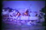
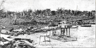
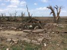
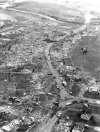
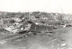
Francisco Beltrão, state of Paraná, Brazil - 2015
This tornado received no rating.


This tornado received no rating.
Follow along with the video below to see how to install our site as a web app on your home screen.
Note: This feature may not be available in some browsers.
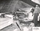
Some of that damage looks potentially violent.Francisco Beltrão, state of Paraná, Brazil - 2015
This tornado received no rating.
View attachment 5093
View attachment 5094
View attachment 5097
View attachment 5098
View attachment 5099
View attachment 5100
View attachment 5095
View attachment 5096
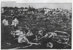
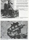
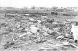
The best collection of damage photos of the San Justo tornado I've been able to find. Yeah, this thing was definitely an F5, and this is probably the most violent tornado damage I've seen outside of the United States.Out of all the tornadoes in South America, the 1973 San Justo tornado was by far the strongest, possibly the strongest recorded anywhere outside the United States. Large factories were leveled, a tractor was thrown 546 yards, homes were completely swept away with debris being granulated, an engine block was embedded in a concrete wall, cars were reduced to scrap metal, intense ground scouring occurred and trees were severely debarked.
It was a surprisingly violent tornado despite being spawned from an exceptionally high cloud base, there was only a 2% area for tornadoes when it touched down.I find it very interesting how the rotational signature on the supercell responsible for the tornado was not impressive at all. View attachment 5020
Here is a LANDSAT image of the scouring the Marion Tornado produced. Contrary to popular belief, it actually started northwest of Marion, moved directly south for most of its life before turning southeast and dissipating near Marion. The scouring is that brown line extending from just parallel to the county line at left to just northeast of a small pond in LaMoure County. The tornado weakened and continued all the way to the Marion area before it dissipated.
View attachment 5021


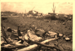
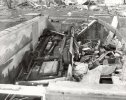
I'd say at least EF3 for sure. Why no rating?Francisco Beltrão, state of Paraná, Brazil - 2015
This tornado received no rating.
View attachment 5093
View attachment 5094
View attachment 5097
View attachment 5098
View attachment 5099
View attachment 5100
View attachment 5095
View attachment 5096


Where did you find these photos?So the Lawrenceburg, TN F5 of 1998 apparently produced very intense ground scouring, with at least one grassy pasture reportedly reduced to bare soil and dirt clumps. Unfortunately, I haven't been able to find photographs of this, but it was apparently Philadelphia, MS-like, with the earth deeply plowed up in some areas. I was however, able to find photos of another pasture that the tornado moved though, and produced similar deep scouring, albeit on a smaller scale. You can see it caused deep, patchy scouring almost identical to that produced on 4/27 by Cordova, Smithville, and Philadelphia. I believe this is likely a hallmark indicative of a remarkably violent Dixie-alley event, with the strange appearance being caused by dense, clay-laden southern soil being dug up by extremely violent suction vortices. I wonder if there are other incidents of this kind of scouring that occurred in historic Dixie events, but have been lost to time?
Also, in case anyone hasn't seen the Cordova scouring, as it doesn't get mentioned much. Like I said, very similar.
The Lawrenceburg, TN ones can be found here in this report: https://www.weather.gov/media/ohx/PDF/april1998stormdata.pdfWhere did you find these photos?
That soil photograph from Lawrenceburg is interesting, it looks like a large object was bounced into the soil several times and made those marks.So the Lawrenceburg, TN F5 of 1998 apparently produced very intense ground scouring, with at least one grassy pasture reportedly reduced to bare soil and dirt clumps. Unfortunately, I haven't been able to find photographs of this, but it was apparently Philadelphia, MS-like, with the earth deeply plowed up in some areas. I was however, able to find photos of another pasture that the tornado moved though, and produced similar deep scouring, albeit on a smaller scale. You can see it caused deep, patchy scouring almost identical to that produced on 4/27 by Cordova, Smithville, and Philadelphia. I believe this is likely a hallmark indicative of a remarkably violent Dixie-alley event, with the strange appearance being caused by dense, clay-laden southern soil being dug up by extremely violent suction vortices. I wonder if there are other incidents of this kind of scouring that occurred in historic Dixie events, but have been lost to time?
Also, in case anyone hasn't seen the Cordova scouring, as it doesn't get mentioned much. Like I said, very similar.
The Lawrenceburg, TN ones can be found here in this report: https://www.weather.gov/media/ohx/PDF/april1998stormdata.pdf
The Cordova ones can be found on an extremeplanet: https://extremeplanet.wordpress.com...outbreak-vs-the-2011-tornado-outbreak-part-i/
I randomly stumbled across the new link for it via google image search, I wonder why he hasn't updated it since 2013 or so.Thanks for also providing the new link to Extreme Planet! I thought it was down.
Hackleburg did some similar damage to this, such as exhibited below (trying to find more pics of it):Yup you’re right. Wind-rowing, with maybe some debris impact scarring of the ground too. I guess it being in black and white kinda threw me.


Given my interest in Dixie Alley events and the Tri-State Tornado, I felt like posting these clips of the Hackleburg. First off, this video is from a storm chase, the incredible forward speed of the tornado is evident throughout (see how quickly it comes to reaching the videographer):
1.
2. This is a classic video of it, so ghostly how it sounds and how quickly it moves through:
3. 5:20 in this vid is the most notable, the width and scope of this thing:
4. This pic of Hackleburg: View attachment 5126
These videos and pictures of the Hackleburg tornado are what most likely match the Tri-State's appearance as a "rolling cloud" hanging low to the ground and moving very fast. So eerie looking at these pics and just how dangerous it was to be caught in the path of a tornado back in 1925. Obviously it's not fun now, but at least we have warnings and public recognition of how to take shelter and the like. Folks back then simply had eyesight and not much else in terms of tornado preparation.
They were also rain-wrapped, fast-moving wedges riding a 'boundary' of some sort and very deadly. They were also both around 1.25-1.3 miles at their widest. Of course, Hackleburg's deadliness is much more shocking given how well-prepared people in the path of it were, whereas Tri-State it's somewhat not surprising given the lack of knowledge of tornadoes and a public warning system back then. Also, the Yazoo City, MS tornado of 2010 is probably a pretty good analog for Tri-State as well, it was on the ground for 149.25 miles for 164 minutes and maxed out at 1.75 miles in width. It left a massive stretch of F3-EF4 damage along almost it's entire path so it undoubtedly achieved EF5 intensity but didn't hit any DI's capable of registering it. The only reason it only killed 10 people is because the majority of it's path was through unpopulated forestland and farmland, only clipping the southwestern side of Yazoo City.I view Hackleburg as the best analog we have to the 1925 Tri-State tornado. They both produced a long swath of EF4/EF5 or F4/F5 damage and had very long paths.
Yazoo City, in addition to being struck by an EF4 on April 24, 2010 was also struck twice on November 29, 2010 by two EF2 tornadoes that both touched down within 20 minutes of one other, pretty crazy. A town struck 3 times in the same year by a tornado, what is the deal down there in Dixie Alley? Also, Cordova, AL was struck twice in a row on 4/27/11, an EF3 in the morning and the long-track EF4 in the late afternoon.Tanner might have the second-worst tornado luck in the country behind Moore, OK after receiving near-EF5 damage from the continuation of the Hackleburg/Phil Campbell tornado of 4/27/11.