Casuarina Head
Member
There seems to be similar violent-tornado corridors in portions of Oklahoma. One runs along I-44 from Chickasha northeastward toward Moore and the southeastern OKC suburbs. Another extends from the Washington–Goldsby area past Norman–Noble, toward Lake Thunderbird and perhaps the Shawnee area. There is also a third possible corridor, though less well defined than the first two, near or just beyond the northwestern OKC suburbs, roughly from El Reno–Yukon to Piedmont–Bethany and thence to around Edmond–Seward or so, perhaps as far as Guthrie. But the southern OKC suburbs and areas southeastward seem by far to get hit hardest by (E)F4+ tornadoes, going back to the late nineteenth century.Yeah, the second Tanner tornado of 1974 went up into Tenn. Also in ‘74, the supercell that put down the first Tanner tornado went over Hackelburg and put down an F2 in Phil Campbell that was the precursor to Tanner1. There are just so many that are in that Corridor.
Even some Mississippi tornadoes, if you follow the path they were on will lead up into that area of Northern Alabama. Smithville leads up that way. Tupelo is another. Heck, the 1920 Hackelburg tornado started in Aberdeen.
And like you mentioned, others like the 1971 Delta and the Yazoo City occurrences… if you follow those paths up, eventually lead into Northwest AL.
The Tuscaloosa/Birmingham corridor also leads back to another area of MS that sees a lot of violent tornadoes: Neshoba county (Philadelphia) and Meridian.
It is like there are two pathways that run Northeast through MS and AL. One runs generally through the Philadelphia/Meridian region and then up to Tuscaloosa/Birmingham. The other from the Columbus/Aberdeen area up into far North AL in the Hackelburg/Russellville/Moultan/Tanner region.
Ive been interested in those two areas for a long time now.
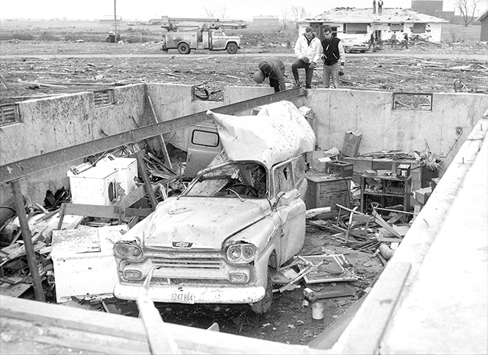
For example, Moore was hit by a very large and violent tornado on 25 April 1893 that traveled anywhere from 15 (per Thomas P. Grazulis) to 45 mi (per NWS Norman), depending on sources, beginning southwst of the settlement and ending perhaps as far as Case, ~12 mi east of Moore. This was also a large wedge-type tornado that killed at least 31 people in and near the southern side of Moore. Signficant Tornadoes rated it F4, perhaps because mainly lightweight structures were destroyed, but at least some homes probably were leveled, and the tornado itself was part of a poorly-documented outbreak that also produced other significant, potentially underrated tornadoes, including near Goldsby (F2) and Guthrie (F4).