• Welcome to TalkWeather!
    We see you lurking around TalkWeather! Take the extra step and join us today to view attachments, see less ads and maybe even join the discussion.
    CLICK TO JOIN TALKWEATHER
Messages
2,157
Reaction score
2,712
Location
Missouri
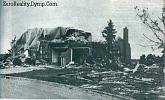
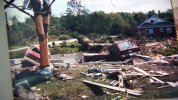
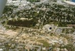
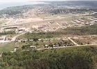
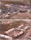
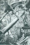
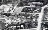
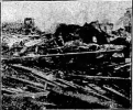
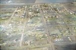
I've mentioned the 1953 Warner Robins F4 before since it was in my hometown, but I'm curious about something. This video was taken on 30 April 1953. (It's extremely annoying that someone attached fake audio to it, but c'est la vie.)

Is it the first ever video of a violent tornado? The first tornado video in the US was taken less than two years before (8 June 1951 in Corn, OK).

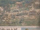
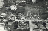
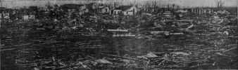
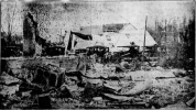
This article has a few newspaper clippings from the tornado, mostly from the AJC. I'd like to see if the local papers had anything, but anything from that era is probably on microfilm rather than digitized.
Really surprised it only had a path length of 1 mile, yeah I think it is most likely the first video footage of a violent tornado....still some of the best tornado footage of all time, even after all these years.
 

warneagle

Member
Messages
3,729
Reaction score
3,208
Location
Arlington, VA
Special Affiliations
  1. SKYWARN® Volunteer
Really surprised it only had a path length of 1 mile, yeah I think it is most likely the first video footage of a violent tornado....still some of the best tornado footage of all time, even after all these years.
Yeah, a lot of the tornadoes from that day had relatively short path lengths, or at least they were recorded that way. I don't know if it's accurate or just a deficiency in the almost 70-year-old records. A lot of the areas affected were still relatively rural at the time, although some of them aren't today.
 

Robinson lee

Member
Messages
72
Reaction score
138
Location
tianjin
I found some pictures of the destruction of the Canadian Barrie Tornado in 1985. Yes, the house has suffered a lot of powerful damage, and the scars left by the tornado are also very obvious. There was another F4 that day, but I don' t have any information about him
 

Attachments

  • barrie19.jpg
    barrie19.jpg
    5.8 KB · Views: 0
  • image.jpg
    image.jpg
    152.4 KB · Views: 0
  • 3f3c28844613b5fffca529913fa4_Gallery.jpeg
    3f3c28844613b5fffca529913fa4_Gallery.jpeg
    78.9 KB · Views: 0
  • images (29).jpeg
    images (29).jpeg
    6.5 KB · Views: 0
  • images (28).jpeg
    images (28).jpeg
    11.9 KB · Views: 0
  • barrie06.jpg
    barrie06.jpg
    82.9 KB · Views: 0
  • barrie07.jpg
    barrie07.jpg
    37.4 KB · Views: 0
  • images (27).jpeg
    images (27).jpeg
    18.3 KB · Views: 0

buckeye05

Member
Messages
3,121
Reaction score
4,581
Location
Colorado
I found some pictures of the destruction of the Canadian Barrie Tornado in 1985. Yes, the house has suffered a lot of powerful damage, and the scars left by the tornado are also very obvious. There was another F4 that day, but I don' t have any information about him
That vehicle damage in the second to last pic Is very impressive. Comparable to some of the worst I’ve ever seen photographed. Very intense debarking too. I suspect that the Barrie tornado was a the higher end of the EF4 range.
 
Messages
2,157
Reaction score
2,712
Location
Missouri
Yeah, a lot of the tornadoes from that day had relatively short path lengths, or at least they were recorded that way. I don't know if it's accurate or just a deficiency in the almost 70-year-old records. A lot of the areas affected were still relatively rural at the time, although some of them aren't today.
I found some pictures of the destruction of the Canadian Barrie Tornado in 1985. Yes, the house has suffered a lot of powerful damage, and the scars left by the tornado are also very obvious. There was another F4 that day, but I don' t have any information about him
This is one the factories completely leveled by Barrie. 16 out of 20 in an industrial park were left in a manner similar to this:

15lbs.jpg

Another photograph of the industrial yard aftermath from the ground:

barrie29.jpg
 
Messages
2,157
Reaction score
2,712
Location
Missouri

Marshal79344

Member
Messages
361
Reaction score
1,064
Location
Chicago, IL
Good lord, there are hundreds of photos from this thing. Pages 1-3 of this thread have some, this blog is a great starting point: https://stormstalker.wordpress.com/2013/06/10/tri-state-tornado/
Yeah, that is probably the most thorough of a summary of the Tri-State-Tornado I've ever seen. I've noticed that the Jackson County Historical Society seems to have a lot of high-definition photos of that thing which is what I'm mainly after, but here's some photos I've found from personal research without stormstalker:
Annapolis
19250318ANNAPOLIS.PNG

Griffin:
19250318ANNAPOLIS.PNG
19250318GRIFFIN2.PNG
19250318GRIFFIN3.PNG
19250318GRIFFIN4.PNG
19250318GRIFFIN5.PNG

Murphysboro
19250318MURPHYSBORO.PNG
19250318MURPHYSBORO2.PNG
 

Attachments

  • 19250318GRIFFIN.PNG
    19250318GRIFFIN.PNG
    306.8 KB · Views: 0
  • 19250318ANNAPOLIS.PNG
    19250318ANNAPOLIS.PNG
    387.9 KB · Views: 0
  • 19250318GRIFFIN5.PNG
    19250318GRIFFIN5.PNG
    137.5 KB · Views: 0

Marshal79344

Member
Messages
361
Reaction score
1,064
Location
Chicago, IL
A lot of newspapers had the same famous photo of damage in West Frankfort in altered versions but here's the most HD one I could find
19250318WESTFRANKFORT7.PNG

More West Frankfort
19250318WESTFRANKFORT2.PNG
19250318WESTFRANKFORT3.PNG
19250318WESTFRANKFORT4.PNG
Planks from obliterated homes lay across the ground outside of West Frankfort
19250318WESTFRANKFORT6.PNG
That's all that I managed to find from hours shifting through online archives of newspapers. Poor people in the path had no chance. One reason that made this tornado incredibly deadly was not only its incredible power, but the fact that it was partially obscured with low LCL heights, as shown by witnesses in Annapolis describing it as a "thick black fog cloud" with a tremendous roar, and not recognizable as an actual funnel at some points. Also, the tornado severed all telegraph communications to cities in the path so residents had no kind of warning of what was approaching until it was right there. The tornado happened to be on a trajectory where multiple large cities were in its path also, a worst-case-scenario
 

Robinson lee

Member
Messages
72
Reaction score
138
Location
tianjin
[QUOTE =“ Juliett Bravo Kilo,帖子:48196,成员:1077”]
这是Barrie完全拉平的工厂之一。在工业园区中每20个中就有16个以类似的方式被留下:

View attachment 4709

另一张从地面上看到的工业场后果的照片:

View attachment 4710
[/引用]
Yes, I believe that if MBS in EF system is used to evaluate the damage of this factory, dod7-8 can be obtained
 

Austin Dawg

Member
Sustaining Member
Messages
852
Reaction score
1,299
Location
Leander, Texas
That's all that I managed to find from hours shifting through online archives of newspapers. Poor people in the path had no chance. One reason that made this tornado incredibly deadly was not only its incredible power, but the fact that it was partially obscured with low LCL heights, as shown by witnesses in Annapolis describing it as a "thick black fog cloud" with a tremendous roar, and not recognizable as an actual funnel at some points. Also, the tornado severed all telegraph communications to cities in the path so residents had no kind of warning of what was approaching until it was right there. The tornado happened to be on a trajectory where multiple large cities were in its path also, a worst-case-scenario

I read that before. They said a lot of people killed were farmers which is not typical because they are so in tune with the weather but evidently did not recognize it was a tornado. That storm always fascinated me and I always wanted to make a documentary about it with historical information, along with modern data and opinions from meteorologists. Now that I am retired after over 20 years in video and film I would really enjoy producing it if I could secure the photos, data, reference materials, access to people in the field, funding, help to sort things, etc.
 

Marshal79344

Member
Messages
361
Reaction score
1,064
Location
Chicago, IL
Does anyone have any other Aerial photos of Fargo other than this one I found, enhanced, and colorized?
 

Attachments

  • 819C3533-75E2-434B-80B3-758C5E7C5FDE.jpeg
    819C3533-75E2-434B-80B3-758C5E7C5FDE.jpeg
    2.9 MB · Views: 0

Marshal79344

Member
Messages
361
Reaction score
1,064
Location
Chicago, IL
Today' s the 15th anniversary of the Stoughton WI F3 occurred on 8/18/2005.Another potential violent tornado, narrow but andover-like violent motion was evident as it went into downtown Stoughton.Numerous FR12 got completely destroyed or leveled though a close inspection shows the missing of some anchors in some houses.Ground scouring can be clearly seen outside town.Would like to go a 165—170mph rating
View attachment 4408View attachment 4409
View attachment 4415
View attachment 4410
View attachment 4416
View attachment 4411
View attachment 4412

View attachment 4413
View attachment 4414
1602296054964.jpegThis picture is of the 2017 Perryville Tornado, an aerial of the area where it clipped the northernmost suburbs along Moore Road and Kingshighway Highway.
 
Messages
2,157
Reaction score
2,712
Location
Missouri
A lot of newspapers had the same famous photo of damage in West Frankfort in altered versions but here's the most HD one I could find
View attachment 4737

More West Frankfort
View attachment 4736
View attachment 4738
View attachment 4739
Planks from obliterated homes lay across the ground outside of West Frankfort
View attachment 4740
That's all that I managed to find from hours shifting through online archives of newspapers. Poor people in the path had no chance. One reason that made this tornado incredibly deadly was not only its incredible power, but the fact that it was partially obscured with low LCL heights, as shown by witnesses in Annapolis describing it as a "thick black fog cloud" with a tremendous roar, and not recognizable as an actual funnel at some points. Also, the tornado severed all telegraph communications to cities in the path so residents had no kind of warning of what was approaching until it was right there. The tornado happened to be on a trajectory where multiple large cities were in its path also, a worst-case-scenario

So, here's a useful resource for Tri-State photos that sadly is only accessible via the Wayback Machine now:

1. https://web.archive.org/web/20160913180314/http://genealogytrails.com/ill/jackson/cahill_photos.htm

2. https://web.archive.org/web/20160913180334/http://genealogytrails.com/ill/jackson/picoftornado.htm

3. https://web.archive.org/web/20160913045125/http://genealogytrails.com/ill/jackson/tornado1925.htm

4. https://web.archive.org/web/2016091...rails.com/ill/jackson/1925tornado_shauna.html
 
Logo 468x120
Back
Top