• Welcome to TalkWeather!
    We see you lurking around TalkWeather! Take the extra step and join us today to view attachments, see less ads and maybe even join the discussion.
    CLICK TO JOIN TALKWEATHER
  • April 2024 Weather Video of the Month
    Post your nominations now!
Messages
2,234
Reaction score
2,825
Location
Missouri
I found this on a news station from PA covering the 5/31/85 event. The caption simply says "tornado north of Pittsburgh, 1985" so I'm not sure which one this is. Whichever of the tornadoes came closet to Pittsburg, I suppose. For some reason I'm thinking it was Atlantic but not sure.


Screenshot 2022-10-19 at 19-15-27 3YVZDX3NG5A6XGZE56KMUS6DZ4.jpg (WEBP Image 1440 × 810 pixels...png
 

AngelAndHisWx

Member
Messages
81
Reaction score
233
Location
New Britain, CT
I found this on a news station from PA covering the 5/31/85 event. The caption simply says "tornado north of Pittsburgh, 1985" so I'm not sure which one this is. Whichever of the tornadoes came closet to Pittsburg, I suppose. For some reason I'm thinking it was Atlantic but not sure.


View attachment 15260
That’s Cabot AR from 1976.
 

TH2002

Member
Sustaining Member
Messages
3,231
Reaction score
4,947
Location
California, United States
Special Affiliations
  1. SKYWARN® Volunteer
The April 10, 2011 Wisconsin tornado outbreak is one that has been discussed here before, but I've done more digging and it continues to amaze me. For those who don't know, several significant tornadoes touched down in Wisconsin on this day, with patches of snow still on the ground and area lakes still frozen. In fact, winter weather followed the tornadoes in a manner reminiscent of the Great Blue Norther of 1911. Given the Stanley tornado last year, this event, Kenosha 2008 and others, perhaps Wisconsin could be the "snow tornado" capital of the world?

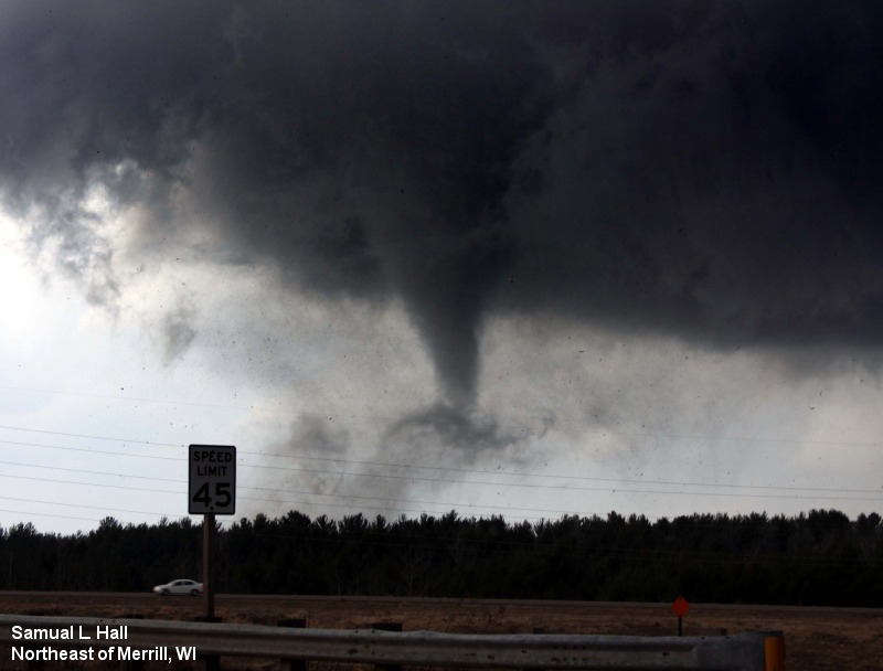
The Merrill EF3 was the strongest tornado of the day and definitely the most well documented, with the tornado being filmed from at least six angles by local residents.

Video of the tornado shortly after its peak intensity in the Airport Road area, as it was weakening and exiting Merrill. Note the patches of snow on the ground, one of only two videos of the tornado in progress that actually show this (the other being the video of it forming). Don't mind the annoying (or hilarious?) commentary...


Photograph of the tornado taken in the same area
Merrill_2.jpg


Video of the aftermath:


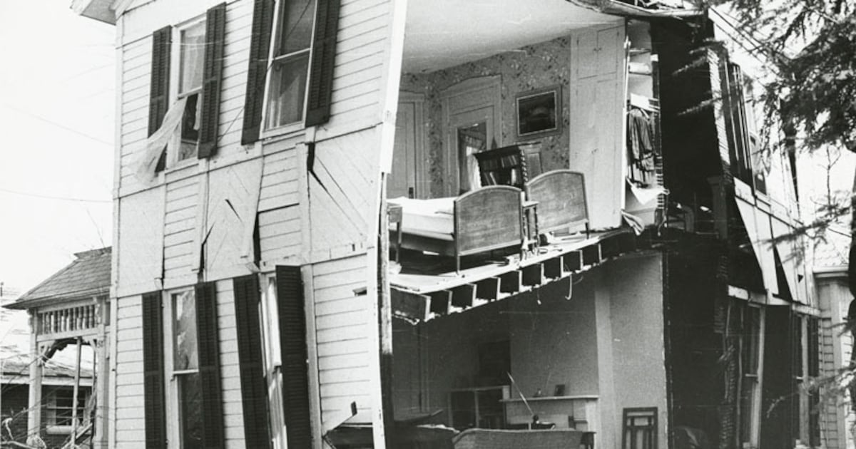
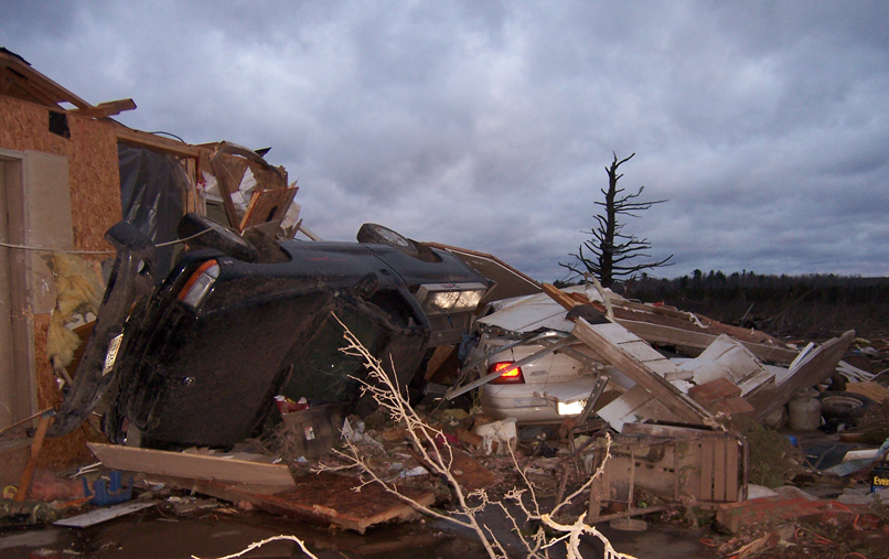
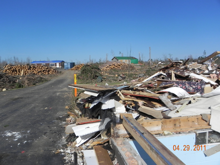
A few assorted damage shots:
TornadoSurvivor%2004.jpg

A-bl-cars.jpg

1666293204768.jpeg
A-jamk-scroeder-house-3.jpg

tornado_005.jpg


I've posted this video before, but I found some more information on it. This was filmed from Gleason facing roughly ENE, probably around the time the Merrill supercell produced the Parrish EF1. Approximately one million trees in total were damaged, snapped or uprooted, and one cabin was destroyed.


After producing the Parrish tornado, the Merrill supercell would produce two more tornadoes in Forest County, one being an EF1 near Armstrong Creek and also an EF2 that was on the ground for twelve miles. Setting down northeast of Crandon and east of Argonne, this tornado caused impressive damage in unpopulated Forest County, with 100% of trees uprooted or snapped in the worst affected areas. This video (particularly after the 1:00 mark) might show the forming stages, and if so it's probably the only footage captured of this tornado.


Intense blowdown of trees
forest-county-tornado-damage.png

And just for fun, here's a chase video of the rain wrapped Arkdale to Cottonville EF2 - 2011 was really the last year people recorded tornadoes with their VHS camcorders (okay, this specific video might be MiniDV but there is the close video of Joplin).
 
Messages
2,857
Reaction score
4,660
Location
Madison, WI
That was Wisconsin's largest April outbreak on record with 15 tornadoes in the state, but it wasn't quite as big as it potentially could have been. Not sure exactly what happened (other than just some Broyles hype), but the forecast the day before called for it to affect areas all the way down to and even a little south of the I-80 corridor in Illinois, but Wisconsin was basically unscathed everywhere south of that Arkdale-Cottonville storm with just very isolated wind and hail reports from there down into Illinois.


Note this snippet from the text:

GREATEST TORNADO THREAT WILL LIKELY EXIST ACROSS ERN IA AND INTO SRN WI/NRN
IL
...NEAR THE SURFACE LOW AND WARM FRONT WHERE LOW-LEVEL SHEAR WILL BE MAXIMIZED.

Not so much...

I was living in Milwaukee at the time (actually close to one of the few severe reports in southern Wisconsin); here's some video I took as the storms rolled in that evening:

 
Messages
681
Reaction score
1,036
Location
Oakland, Tennessee
That was Wisconsin's largest April outbreak on record with 15 tornadoes in the state, but it wasn't quite as big as it potentially could have been. Not sure exactly what happened (other than just some Broyles hype), but the forecast the day before called for it to affect areas all the way down to and even a little south of the I-80 corridor in Illinois, but Wisconsin was basically unscathed everywhere south of that Arkdale-Cottonville storm with just very isolated wind and hail reports from there down into Illinois.


Note this snippet from the text:


Not so much...

I was living in Milwaukee at the time (actually close to one of the few severe reports in southern Wisconsin); here's some video I took as the storms rolled in that evening:


Let's not forget about the day previous, with the very long tracked Pocahontas EF3 and it's many many satellites.
Wikipedia:
"It was associated with six satellite tornadoes, including two simultaneous in Buena Vista County and four simultaneous in Pocahontas County, with five tornadoes on the ground at one time from 02:56–02:58 UTC. This tornado took a very erratic path, turning eastward and northward along a northeasterly track, producing an unusual and varying debris field; the track ended just west-southwest of Havelock."
 

TH2002

Member
Sustaining Member
Messages
3,231
Reaction score
4,947
Location
California, United States
Special Affiliations
  1. SKYWARN® Volunteer
Nice work! Especially love the Brandenburg drawing.

The Tri-State one is pretty interesting to me too; since there's no photographs of the tornado (obviously) all we can do is speculate about what the storm might have looked like, though based on survivor accounts I've always thought it probably had an appearance similar to Hackleburg. Anyhow, welcome to the forums!
 
Messages
2,234
Reaction score
2,825
Location
Missouri
Nice work! Especially love the Brandenburg drawing.

The Tri-State one is pretty interesting to me too; since there's no photographs of the tornado (obviously) all we can do is speculate about what the storm might have looked like, though based on survivor accounts I've always thought it probably had an appearance similar to Hackleburg. Anyhow, welcome to the forums!
Guin also has no known photographs, even worse that it occurred at night. Of course, it was likely a violent wedge also like Hackleburg or the Tri-State but no way to know for sure.
I'm sure there's a photograph out there of the Tri-State in someone's attic or buried in some local archives that likely will never be found, shame really.
 
Messages
681
Reaction score
1,036
Location
Oakland, Tennessee
Guin also has no known photographs, even worse that it occurred at night. Of course, it was likely a violent wedge also like Hackleburg or the Tri-State but no way to know for sure.
I'm sure there's a photograph out there of the Tri-State in someone's attic or buried in some local archives that likely will never be found, shame really.
Brandenburg doesn't have any known photographs either unless I've missed one.

Speaking of violent 70's tornadoes, I was going through Twitter on a Mass violent tornado binge when this post caught my eye:


Is that an actual photo of the Windsor Locks F4? Lord knows but I did a Google image search and it turned up no matches.
 
Messages
2,234
Reaction score
2,825
Location
Missouri
Brandenburg doesn't have any known photographs either unless I've missed one.

Speaking of violent 70's tornadoes, I was going through Twitter on a Mass violent tornado binge when this post caught my eye:


Is that an actual photo of the Windsor Locks F4? Lord knows but I did a Google image search and it turned up no matches.

At first I thought it was DePauw what with the lack of a clear condensation funnel, but Yandex tells me it's Xenia:

EDIT: Here's a link with it the pic in a slideshow:

 
Messages
681
Reaction score
1,036
Location
Oakland, Tennessee
At first I thought it was DePauw what with the lack of a clear condensation funnel, but Yandex tells me it's Xenia:

EDIT: Here's a link with it the pic in a slideshow:

Ah......Darn it. Thought I had something.
 
Back
Top