
Yup, in fact, one of the surveyors from JAN said it was the most violent tree damage he’d ever seen in his whole career. That says a lot imo.The extreme tree damage was suggestive of a high-end violent tornado.
Navigation
Install the app
How to install the app on iOS
Follow along with the video below to see how to install our site as a web app on your home screen.
Note: This feature may not be available in some browsers.
More options
-
Welcome to TalkWeather! We see you lurking around TalkWeather! Take the extra step and join us today to view attachments, see less ads and maybe even join the discussion. CLICK TO JOIN TALKWEATHER
You are using an out of date browser. It may not display this or other websites correctly.
You should upgrade or use an alternative browser.
You should upgrade or use an alternative browser.
Significant Tornado Events
- Thread starter locomusic01
- Start date
It did mainly EF3 level damage with pockets of EF4 damage as it was the widest with 2 miles + wide. The damage from that part was quite identical to Yazoo City. It reintensified into an low end EF4 as it entered into Moss. But the very beginning 10 miles of its path was certainly the strongest part.Aside from being 2+ miles wide, what exactly about Bassfield made it really impressive? I haven't reviewed much damage pics from it.
Another competitor was Omaha tornado 1913. But this value was far less than Charley City and Ruskin Height.I also forgot there was an engineer that estimated the wind speeds in the 1896 St. Louis - East St. Louis tornado at 400-500 mph on the basis of a 2x4 being driven through a plate girder of the Eads bridge. So I guess there's more competition than I thought.
(That one was pretty impressive, though.)

Here are some damage pictures from this tornado.Aside from being 2+ miles wide, what exactly about Bassfield made it really impressive? I haven't reviewed much damage pics from it.

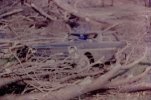
There were so some many tornados left scars in rural areas years after years. This one, by far left one of the most clear defined scar that I have ever seen. It can be seen from the bottom of the picuture that a mobile house were lofted and its debris field scattered over 300 yards downwind. Tornado quickly widened with a clear defined narrow centerline all along with the path showed in this picture.
Mama Dee's Cafe along Harper Road was swept clean of its foundation with only a slab left. Closer view showed anchor bolted of the house was bent. Vehicle nearby was tossed and trees downwind were debarked.


The high end EF4 rating was from a well anchored house swept away along Graves Key Road. The potential vehicle impact certainly hinder from higher rating in this place.But one thing should be noticed was that most of anchor bolts from the house was bent towards the centerline of the tornado including some of them was pulled out of the concrete foundation of the house. The same phenomenon was observed in Smithville MS.These bent anhored certainly had nothing to do with the potential vehicle impact. It just showed how powerfull tornado in here and I know bent anchored had been used as one of the reason to upgrade several straight nailed houses of Moore OK 2013 to EF5 rating.


This house was still 60 yards away from the center line of the tornado.The truck parked in front of the house was tossed 300 yards downwind with debris from the house. Some of these debris was churn into not just match-sticking, more like rice shaped particle.

Last edited:
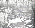
The whole forest East of the house was leveled. Hundred and hundreds of trees were blown down with no leaf can be found, even on the ground. Trees were debarked with nearly no debris loading in this place.

Further east of this place, along Wille Fortenburry Road, another forest was completely leveled with highly symmetrical treefall pattern.The back convergence feature of this treefall pattern was the most extreme I have ever noticed.

As tornado enter into East of Wille Fortenburry Road, it made that famous tree damage with entire hardwood forest along the center line of the tornado was completely debarked and denuded. Vehicle was tossed from the weaker side of the tornado.

This tree damage, IMHO, represent the upper limit that a tornado can damage to a forest. It just can't be worse than this.
The wind rowing feature in a forest was so rare to see.(showed in the red arrow)

Low level vegatation had no chance to survive. It was completely annihilated by the tornado. (showed in the red arrow) Many trees along the centerline were mowed down to a just stump left behind. Some of these stump were split in half and these half stump were also completely debarked. Scoured grass were evident near these debarked stumps. All these damage was done with no more than 2 or 3 seconds due to the fast speed and very narrow core feature.

Even in such rural area, the tree damage here can rival any powerful tornado hit town or city. With no residence debris along this centerline here, these debarking was done mainly by, and actually only by broken branches and fallen leaves of the trees .
Further east of this place, a car was tossed very likely at least half mile laying in the field with its body completely mangled.

Tornado was more than 1.5 miles wide here still with a clear defined narrow center line no more than 50-100 yards. This structure alone was interesting enough to discuss. The most comparable case that I can recall was Hackleburg tornado in Oak Grove with one mile wide circulation and a well defined core no more than 100 yards. NWS defined tornado reached peak intensity here with winds 210mph.
Hackleburg:

Smithville was about 7/10 mile wide with a clear defined narrow cone when it hit the town. Vilonia was about 3/4 mile wide with a clear defined cone when it hit the town. Just for a reference, I am a big fan of typical cyclone so I know that TC with big circulation and narrow pinhole clear eye usually have lowest pressure compared to other TCs such as Tip1979(870hpa), Patricia2015(872hpa from KZC and Best Track of NHC),
June1976(875hpa), Forrest1983(883hpa ,876hpa deducted from Potential height), IDA 1958(873hpa deducted from Potential height), Vanessa1984(879hpa), Dianmu2004, Hagibis2019, Olaf2005 and so on.This structure allows the low pressure system to have more space to deepen its pressure than normal structure. Though there still can be a great difference between structure of TCs and tornados.
Hagibis 2019:

In this place, about 400-600 yards north of the core of the tornado, which was the weaker side of the tornado due to moving speed about 60mph here, there was mid level EF3 structure damage and completely flatten chicken houses. Debris of these structures all tossed towards the center of the tornado. This just showed how intense pressure gredient was in this place.

highly symmetrical treefall pattern once again showed up as tornado enter the forest area. Tornado continuely widen and its core was no more evident thereafter.It is a really big fortune that this tornado didn't hit a town at its peak intensity.
It's also worth mentioned that this big circulation/narrow core feature even can be judged from radar in this place.

Further east of this place, along Wille Fortenburry Road, another forest was completely leveled with highly symmetrical treefall pattern.The back convergence feature of this treefall pattern was the most extreme I have ever noticed.
As tornado enter into East of Wille Fortenburry Road, it made that famous tree damage with entire hardwood forest along the center line of the tornado was completely debarked and denuded. Vehicle was tossed from the weaker side of the tornado.
This tree damage, IMHO, represent the upper limit that a tornado can damage to a forest. It just can't be worse than this.
The wind rowing feature in a forest was so rare to see.(showed in the red arrow)
Low level vegatation had no chance to survive. It was completely annihilated by the tornado. (showed in the red arrow) Many trees along the centerline were mowed down to a just stump left behind. Some of these stump were split in half and these half stump were also completely debarked. Scoured grass were evident near these debarked stumps. All these damage was done with no more than 2 or 3 seconds due to the fast speed and very narrow core feature.
Even in such rural area, the tree damage here can rival any powerful tornado hit town or city. With no residence debris along this centerline here, these debarking was done mainly by, and actually only by broken branches and fallen leaves of the trees .
Further east of this place, a car was tossed very likely at least half mile laying in the field with its body completely mangled.
Tornado was more than 1.5 miles wide here still with a clear defined narrow center line no more than 50-100 yards. This structure alone was interesting enough to discuss. The most comparable case that I can recall was Hackleburg tornado in Oak Grove with one mile wide circulation and a well defined core no more than 100 yards. NWS defined tornado reached peak intensity here with winds 210mph.
Hackleburg:
Smithville was about 7/10 mile wide with a clear defined narrow cone when it hit the town. Vilonia was about 3/4 mile wide with a clear defined cone when it hit the town. Just for a reference, I am a big fan of typical cyclone so I know that TC with big circulation and narrow pinhole clear eye usually have lowest pressure compared to other TCs such as Tip1979(870hpa), Patricia2015(872hpa from KZC and Best Track of NHC),
June1976(875hpa), Forrest1983(883hpa ,876hpa deducted from Potential height), IDA 1958(873hpa deducted from Potential height), Vanessa1984(879hpa), Dianmu2004, Hagibis2019, Olaf2005 and so on.This structure allows the low pressure system to have more space to deepen its pressure than normal structure. Though there still can be a great difference between structure of TCs and tornados.
Hagibis 2019:
In this place, about 400-600 yards north of the core of the tornado, which was the weaker side of the tornado due to moving speed about 60mph here, there was mid level EF3 structure damage and completely flatten chicken houses. Debris of these structures all tossed towards the center of the tornado. This just showed how intense pressure gredient was in this place.
highly symmetrical treefall pattern once again showed up as tornado enter the forest area. Tornado continuely widen and its core was no more evident thereafter.It is a really big fortune that this tornado didn't hit a town at its peak intensity.
It's also worth mentioned that this big circulation/narrow core feature even can be judged from radar in this place.
Last edited:
Marshal79344
Member
Here's a terrible, terrible quality photo I have of the home swept away by Red Rock

Marshal79344
Member
One thing to keep in mind when talking about the Bassfield Tornado is how debarking of trees is usually done by debris, not the actual winds inside the tornado itself. There was only 1 structure near the grove of trees that sustained total debarking, a home to the north which got an EF3 rating. Despite the lack of structures nearby, considering that the Bassfield tornado was still able to completely strip those trees of every last bit of foliage is a testament to how incredibly violent that tornado was, and cements its place as one of the most violent ever recorded in Dixie Alley.
Photo of the particular grove I'm talking about, located along Willie Fortenberry Road

Tree damage near the restaurant, where I think 4 were killed also suggested a violent tornado


Photo of the particular grove I'm talking about, located along Willie Fortenberry Road
Tree damage near the restaurant, where I think 4 were killed also suggested a violent tornado
MNTornadoGuy
Member
Extreme debarking from the Pilger tornadoes.


Marshal79344
Member
Everybody knows that most tornadoes in the northeast come from either partial northwest flow or completely northwest flow setups. It's not uncommon to see the midwest get hit during the summer, as the surface low progression gradually trends further north as the year goes on. However, there was something about the intensity of the surface low that transverse the Canada/USA border from June 7th to June 9th, 1953 that was just off. Most tornado events in the northeast come from surface lows that aren't that intense, such as the 1924 Lorain - Sandusky, OH event. However, the intensity of this low, as it passed over New York, Vermont, and Maine on the afternoon of June the 9th, 1953 was much higher than any other event I know of in that area. The pressure falls, strong kinematic support, and the fact that warm air had already advected that far north by that time of year (which is nothing unusual) combined perfectly to support the formation of a discrete supercell thunderstorm that wrought the worst havoc of any supercell thunderstorm in the northeast. Nothing like the Worcester Tornado had preceded it, and nothing of its intensity in that area has succeeded it. The tornado was of such unprecedented severity that right after the monster had passed, people actually thought that the Soviets (remember the Cold War was ongoing at this time with Nikita Khrushchev) had attacked the city of Worcester. There's one image of the tornado, taken from a street called Brattle, which confirms the intensity of the tornado, based on visual appearance. It shows the entire wall cloud structure and massive tornado below it. You can see a massive lowering and a gigantic tail (inflow) cloud into the Worcester Tornado. That is textbook violent tornado structure, and similar to some of the stuff I've seen from April 27, 2011.

ERA5 Reanalysis nailed the Worcester Tornado Environment. Having that much stretching in an instability profile, combined with strong shear (ERA5 has a tendency to under-do kinematics sometimes), is going to result in a major disaster. Add all of that streamwise vorticity, and man, this is going to be a classic semi-northwest flow tornado event. It's evident that ERA5 underdid the kinematics somewhat, as it shows a textbook high-precipitation supercell setup, as seen from the SR Wind with height graph. However, by all photographic evidence, the Worcester Tornado appeared to be quite visible (correct me if I'm wrong.) This is evidence that the shear was strong enough to vent the updraft free of precipitation, which tells me that the actual hodograph would have been larger, and the wind shear values higher.

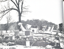
The tornado immediately became large and violent and produced catastrophic, textbook violent-tornado devastation in the suburbs of Worcester. The Worcester Tornado was responsible for the only clear-cut, classic violent tornado damage indicators in far northeastern history. The worst-hit area was that along a street called Uncatena Avenue, where every single home in the path was reduced to a slab foundation. Several other neighborhoods were stricken badly as well. The tornado also struck Assumption College and took a good portion of the upper floors off of the massive brick structures. It's unfortunately no surprise that 94 people lost their lives in the horrific monster.
The devastated Uncatena Avenue suburbs after the tornado


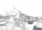
Other neighborhoods that sustained violent-intensity devastation


The remains of Assumption College after the monster, there's no better word to describe such a catastrophically violent tornado, had finished its work.

All in all, it makes me wonder, what would happen if the Worcester Tornado occurred today? Not that many people who were alive and witnessed the devastation of June the 9th, 1953 first-hand are still around to tell the tale. They are among the only people living in the northeast that truly have an unwavering respect for mother nature. Those who were affected by the intense Springfield Tornado of 2011 also have a fierce respect for mother nature, but they lived south of the path. I'm sure that countless tornado warnings, which thankfully did not result in anything too significant, have occurred over Worcester. As the older generation gives way to younger generations, I have a feeling that a tornado warning would be ignored. The mentality of, "Oh what happened the last 500 times we got a Tornado Warning? Nothing. So why would this be any different," would kill several. The death toll would likely be similar, or even higher, due to most people not taking the situation seriously until the tornado would already be on top of them. All we know is that it will happen again, we just don't know when and where until right before it occurs.
One more thing, if there was a tornado rated F4 from before 1990 that I could change to F5, this is it.
ERA5 Reanalysis nailed the Worcester Tornado Environment. Having that much stretching in an instability profile, combined with strong shear (ERA5 has a tendency to under-do kinematics sometimes), is going to result in a major disaster. Add all of that streamwise vorticity, and man, this is going to be a classic semi-northwest flow tornado event. It's evident that ERA5 underdid the kinematics somewhat, as it shows a textbook high-precipitation supercell setup, as seen from the SR Wind with height graph. However, by all photographic evidence, the Worcester Tornado appeared to be quite visible (correct me if I'm wrong.) This is evidence that the shear was strong enough to vent the updraft free of precipitation, which tells me that the actual hodograph would have been larger, and the wind shear values higher.
The tornado immediately became large and violent and produced catastrophic, textbook violent-tornado devastation in the suburbs of Worcester. The Worcester Tornado was responsible for the only clear-cut, classic violent tornado damage indicators in far northeastern history. The worst-hit area was that along a street called Uncatena Avenue, where every single home in the path was reduced to a slab foundation. Several other neighborhoods were stricken badly as well. The tornado also struck Assumption College and took a good portion of the upper floors off of the massive brick structures. It's unfortunately no surprise that 94 people lost their lives in the horrific monster.
The devastated Uncatena Avenue suburbs after the tornado
Other neighborhoods that sustained violent-intensity devastation
The remains of Assumption College after the monster, there's no better word to describe such a catastrophically violent tornado, had finished its work.
All in all, it makes me wonder, what would happen if the Worcester Tornado occurred today? Not that many people who were alive and witnessed the devastation of June the 9th, 1953 first-hand are still around to tell the tale. They are among the only people living in the northeast that truly have an unwavering respect for mother nature. Those who were affected by the intense Springfield Tornado of 2011 also have a fierce respect for mother nature, but they lived south of the path. I'm sure that countless tornado warnings, which thankfully did not result in anything too significant, have occurred over Worcester. As the older generation gives way to younger generations, I have a feeling that a tornado warning would be ignored. The mentality of, "Oh what happened the last 500 times we got a Tornado Warning? Nothing. So why would this be any different," would kill several. The death toll would likely be similar, or even higher, due to most people not taking the situation seriously until the tornado would already be on top of them. All we know is that it will happen again, we just don't know when and where until right before it occurs.
One more thing, if there was a tornado rated F4 from before 1990 that I could change to F5, this is it.
MNTornadoGuy
Member
Here is my next post about the May 6, 1965 tornado outbreak, this time I will talk about the Chanhassen-Deephaven F4. This intense tornado touched down a mile south of Chanhassen and moved directly north through downtown. A lumber warehouse was severely damaged, a gas station was destroyed, a shopping center was damaged and multiple homes were torn apart or unroofed. As it moved into Deephaven it rapidly intensified into the F3-F4 range. Homes (including some that were large and expensive according to Grazulis) were completely leveled, trees were partially debarked and boats were tossed through the air. The tornado then moved over Lake Minnetonka and dissipated. One person was killed by this tornado.


.png")


MNTornadoGuy
Member


Attachments
-
 11174360_10205525157760599_8655964620305007710_o.jpg206.1 KB · Views: 0
 -
 005C3457-10A4-4343-8ECC-2B67660B2A18.png2.3 MB · Views: 0
 -
 DEC3E521-36DD-4F9A-8080-A8ACEFCCFEBA.png1.7 MB · Views: 0
 -
 2B2FAE7F-B7CA-4C17-8D92-89C2816A8CEB.png3.1 MB · Views: 0
 -
 68010360-2DE8-4062-8466-BBAA485AB4C4.png2.4 MB · Views: 0
There are very few images of the damage that this tornado produced. Video evidence and the radar data captured by Bluestein et al. obviously suggests a high end tornado, but that’s the first time I’ve seen seen damage on that level. I’d be surprised if it didn’t produce scouring/debarking.Here's a terrible, terrible quality photo I have of the home swept away by Red Rock
Juliett Bravo Kilo
Member
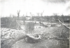
The whole forest East of the house was leveled. Hundred and hundreds of trees were blown down with no leaf can be found, even on the ground. Trees were debarked with nearly no debris loading in this place.
View attachment 8181
Further east of this place, along Wille Fortenburry Road, another forest was completely leveled with highly symmetrical treefall pattern.The back convergence feature of this treefall pattern was the most extreme I have ever noticed.
View attachment 8173
As tornado enter into East of Wille Fortenburry Road, it made that famous tree damage with entire hardwood forest along the center line of the tornado was completely debarked and denuded. Vehicle was tossed from the weaker side of the tornado.
View attachment 8176
This tree damage, IMHO, represent the upper limit that a tornado can damage to a forest. It just can't be worse than this.
The wind rowing feature in a forest was so rare to see.(showed in the red arrow)
View attachment 8174
Low level vegatation had no chance to survive. It was completely annihilated by the tornado. (showed in the red arrow) Many trees along the centerline were mowed down to a just stump left behind. Some of these stump were split in half and these half stump were also completely debarked. Scoured grass were evident near these debarked stumps. All these damage was done with no more than 2 or 3 seconds due to the fast speed and very narrow core feature.
View attachment 8175
Even in such rural area, the tree damage here can rival any powerful tornado hit town or city. With no residence debris along this centerline here, these debarking was done mainly by, and actually only by broken branches and fallen leaves of the trees .
Further east of this place, a car was tossed very likely at least half mile laying in the field with its body completely mangled.
View attachment 8177
Tornado was more than 1.5 miles wide here still with a clear defined narrow center line no more than 50-100 yards. This structure alone was interesting enough to discuss. The most comparable case that I can recall was Hackleburg tornado in Oak Grove with one mile wide circulation and a well defined core no more than 100 yards. NWS defined tornado reached peak intensity here with winds 210mph.
Hackleburg:
View attachment 8187
Smithville was about 7/10 mile wide with a clear defined narrow cone when it hit the town. Vilonia was about 3/4 mile wide with a clear defined cone when it hit the town. Just for a reference, I am a big fan of typical cyclone so I know that TC with big circulation and narrow pinhole clear eye usually have lowest pressure compared to other TCs such as Tip1979(870hpa), Patricia2015(872hpa from KZC and Best Track of NHC),
June1976(875hpa), Forrest1983(883hpa ,876hpa deducted from Potential height), IDA 1958(873hpa deducted from Potential height), Vanessa1984(879hpa), Dianmu2004, Hagibis2019, Olaf2005 and so on.This structure allows the low pressure system to have more space to deepen its pressure than normal structure. Though there still can be a great difference between structure of TCs and tornados.
Hagibis 2019:
View attachment 8186
In this place, about 400-600 yards north of the core of the tornado, which was the weaker side of the tornado due to moving speed about 60mph here, there was mid level EF3 structure damage and completely flatten chicken houses. Debris of these structures all tossed towards the center of the tornado. This just showed how intense pressure gredient was in this place.
View attachment 8180
highly symmetrical treefall pattern once again showed up as tornado enter the forest area. Tornado continuely widen and its core was no more evident thereafter.It is a really big fortune that this tornado didn't hit a town at its peak intensity.
It's also worth mentioned that this big circulation/narrow core feature even can be judged from radar in this place.
View attachment 8191
Yeah this thing should have been rated EF5. Yet another underrated tornado. I'm really impressed by the tree damage and ground scouring from this thing.
Juliett Bravo Kilo
Member
Grazulis has said that rating this thing F4 instead of F5 is one of his biggest regrets.Everybody knows that most tornadoes in the northeast come from either partial northwest flow or completely northwest flow setups. It's not uncommon to see the midwest get hit during the summer, as the surface low progression gradually trends further north as the year goes on. However, there was something about the intensity of the surface low that transverse the Canada/USA border from June 7th to June 9th, 1953 that was just off. Most tornado events in the northeast come from surface lows that aren't that intense, such as the 1924 Lorain - Sandusky, OH event. However, the intensity of this low, as it passed over New York, Vermont, and Maine on the afternoon of June the 9th, 1953 was much higher than any other event I know of in that area. The pressure falls, strong kinematic support, and the fact that warm air had already advected that far north by that time of year (which is nothing unusual) combined perfectly to support the formation of a discrete supercell thunderstorm that wrought the worst havoc of any supercell thunderstorm in the northeast. Nothing like the Worcester Tornado had preceded it, and nothing of its intensity in that area has succeeded it. The tornado was of such unprecedented severity that right after the monster had passed, people actually thought that the Soviets (remember the Cold War was ongoing at this time with Nikita Khrushchev) had attacked the city of Worcester. There's one image of the tornado, taken from a street called Brattle, which confirms the intensity of the tornado, based on visual appearance. It shows the entire wall cloud structure and massive tornado below it. You can see a massive lowering and a gigantic tail (inflow) cloud into the Worcester Tornado. That is textbook violent tornado structure, and similar to some of the stuff I've seen from April 27, 2011.
View attachment 8199
ERA5 Reanalysis nailed the Worcester Tornado Environment. Having that much stretching in an instability profile, combined with strong shear (ERA5 has a tendency to under-do kinematics sometimes), is going to result in a major disaster. Add all of that streamwise vorticity, and man, this is going to be a classic semi-northwest flow tornado event. It's evident that ERA5 underdid the kinematics somewhat, as it shows a textbook high-precipitation supercell setup, as seen from the SR Wind with height graph. However, by all photographic evidence, the Worcester Tornado appeared to be quite visible (correct me if I'm wrong.) This is evidence that the shear was strong enough to vent the updraft free of precipitation, which tells me that the actual hodograph would have been larger, and the wind shear values higher.
View attachment 8200
The tornado immediately became large and violent and produced catastrophic, textbook violent-tornado devastation in the suburbs of Worcester. The Worcester Tornado was responsible for the only clear-cut, classic violent tornado damage indicators in far northeastern history. The worst-hit area was that along a street called Uncatena Avenue, where every single home in the path was reduced to a slab foundation. Several other neighborhoods were stricken badly as well. The tornado also struck Assumption College and took a good portion of the upper floors off of the massive brick structures. It's unfortunately no surprise that 94 people lost their lives in the horrific monster.
The devastated Uncatena Avenue suburbs after the tornado
View attachment 8201
View attachment 8202
View attachment 8203
Other neighborhoods that sustained violent-intensity devastation
View attachment 8205View attachment 8206View attachment 8204
The remains of Assumption College after the monster, there's no better word to describe such a catastrophically violent tornado, had finished its work.
View attachment 8207
All in all, it makes me wonder, what would happen if the Worcester Tornado occurred today? Not that many people who were alive and witnessed the devastation of June the 9th, 1953 first-hand are still around to tell the tale. They are among the only people living in the northeast that truly have an unwavering respect for mother nature. Those who were affected by the intense Springfield Tornado of 2011 also have a fierce respect for mother nature, but they lived south of the path. I'm sure that countless tornado warnings, which thankfully did not result in anything too significant, have occurred over Worcester. As the older generation gives way to younger generations, I have a feeling that a tornado warning would be ignored. The mentality of, "Oh what happened the last 500 times we got a Tornado Warning? Nothing. So why would this be any different," would kill several. The death toll would likely be similar, or even higher, due to most people not taking the situation seriously until the tornado would already be on top of them. All we know is that it will happen again, we just don't know when and where until right before it occurs.
One more thing, if there was a tornado rated F4 from before 1990 that I could change to F5, this is it.
Also, in terms of people in New England having unwavering respect for mother nature, I'm sure that people in Connecticut likely do as well due to the Windsor Locks event of 1979 and some other past tornado events.
MNTornadoGuy
Member
Photographs of the Chanhassen-Deephaven tornado:


Something interesting to note is that all the tornadoes during this outbreak were highly visible and could be seen from miles away.
Something interesting to note is that all the tornadoes during this outbreak were highly visible and could be seen from miles away.
While I agree it probably contained EF5 winds, you can’t rate a tornado EF5 based on tree damage. Given the structural flaws and evidence of vehicle impact they found at the only totally slabbed house along the path, high-end EF4 was really their only choice,Yeah this thing should have been rated EF5. Yet another underrated tornado. I'm really impressed by the tree damage and ground scouring from this thing.
Juliett Bravo Kilo
Member
So can vehicles thrown long distances not be used for EF5? Also, what is the highest rating that tree damage can be assigned?While I agree it probably contained EF5 winds, you can’t rate a tornado EF5 based on tree damage. Given the structural flaws and evidence of vehicle impact they found at the only totally slabbed house along the path, high-end EF4 was really their only choice,
I see why they rated it the way they did, I'm just curious for details on certain factors and damage indicators and the like. Not sure how else to word that.
MNTornadoGuy
Member
Low-end EF4 is the highest a tree can be rated.So can vehicles thrown long distances not be used for EF5? Also, what is the highest rating that tree damage can be assigned?
I see why they rated it the way they did, I'm just curious for details on certain factors and damage indicators and the like. Not sure how else to word that.
speedbump305
Member
i will say, anchors being bent and torn out, might be normal for EF5 tornadoes. but i bet a lot of tornaodes rated EF5 have torn anchorsOne thing to keep in mind when talking about the Bassfield Tornado is how debarking of trees is usually done by debris, not the actual winds inside the tornado itself. There was only 1 structure near the grove of trees that sustained total debarking, a home to the north which got an EF3 rating. Despite the lack of structures nearby, considering that the Bassfield tornado was still able to completely strip those trees of every last bit of foliage is a testament to how incredibly violent that tornado was, and cements its place as one of the most violent ever recorded in Dixie Alley.
Photo of the particular grove I'm talking about, located along Willie Fortenberry Road
View attachment 8194
Tree damage near the restaurant, where I think 4 were killed also suggested a violent tornado
View attachment 8193
View attachment 8195