• Welcome to TalkWeather!
    We see you lurking around TalkWeather! Take the extra step and join us today to view attachments, see less ads and maybe even join the discussion.
    CLICK TO JOIN TALKWEATHER

pohnpei

Member
Messages
958
Reaction score
1,953
Location
shanghai
I always found this video from 2011 El Reno EF5 was quite impressive


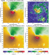
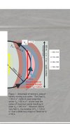
Based on the coordinates provided by the video, I can locate it in Google Earth as the follow picture:
QQ截图20200119234152.jpg
And it was really close to the main tornado cirulation! The tornadic flow in this footage was strong enough to spin and move the vehicle.
It was about 1 minutes after it the tornado strike the Cactus-117 station and do increible damage and also 10 minutes before that the peak measurement of 295.5mph made by RaxPol radar. (then tornado moved away from radar)
About 10 minutes after the end of the video, the tornado hit a weather station having a 151mph wind record 620m south of tornado center and a 17 hpa drop of pressure.
QQ图片20191024180238.pngel-reno-mesonet-station-may2011.jpg
24may11-elrenomeso-600x392.jpg
 
Last edited:

andyhb

Member
Messages
1,083
Reaction score
2,936
Location
Norman, OK
I'm pretty sure the peak wind measurement of 295 mph is from a sub-vortex within the 2013 El Reno tornado and not the 2011 one. The 2011 one peaked at somewhere around 125 m/s (280 mph) IIRC. Of course, this may not (and probably isn't) the actual peak ground-relative velocity achieved since the radar only observed the tornado for a short time in its long lifespan. Both velocities are also well into not only the EF5 windspeeds, but the old F5 windspeeds.
 

pohnpei

Member
Messages
958
Reaction score
1,953
Location
shanghai
I'm pretty sure the peak wind measurement of 295 mph is from a sub-vortex within the 2013 El Reno tornado and not the 2011 one. The 2011 one peaked at somewhere around 125 m/s (280 mph) IIRC. Of course, this may not (and probably isn't) the actual peak ground-relative velocity achieved since the radar only observed the tornado for a short time in its long lifespan. Both velocities are also well into not only the EF5 windspeeds, but the old F5 windspeeds.
the small vortex from 2013 El reno was between 130m/s-150m/s during 232525-232534UTC.
The peak measurement of 132.1m/s from 2011 El Reno was around 210039UTC.
 

Attachments

  • 10-05-31-waf-d-14-00026.1-f13.gif
    10-05-31-waf-d-14-00026.1-f13.gif
    105 KB · Views: 0
  • Screenshot_2020-05-07-14-13-23-269_cn.wps.moffice_eng.xiaomi.lite.jpg
    Screenshot_2020-05-07-14-13-23-269_cn.wps.moffice_eng.xiaomi.lite.jpg
    629 KB · Views: 0
Last edited:

andyhb

Member
Messages
1,083
Reaction score
2,936
Location
Norman, OK
the small vortex from 2013 El reno was between 130m/s-150m/s during 232525-232534UTC.
The peak measurement from 2011 El Reno was around 210039UTC.

Thanks for this. It's worth noting that measurements of "peak V" in these tornadoes can vary. Instantaneous gusts (which I believe is what that 132 m/s measurement is) are different than 2 or 4 second averaged gusts. The three second gust is usually standard for measuring wind speeds in tornadoes. Even the four second gust there is 110.8 m/s -> close to 250 mph. The other issue comes with dealiasing, which leads to ambiguity, especially when you have intense gradients in Doppler velocities like those present in strong tornadoes.

With that said, I have little doubt that the 2011 El Reno tornado had peak winds AGL well in excess of 200 mph, probably at several portions or even the majority of its lifespan. That tornado was a true monster.
 

pohnpei

Member
Messages
958
Reaction score
1,953
Location
shanghai
Thanks for this. It's worth noting that measurements of "peak V" in these tornadoes can vary. Instantaneous gusts (which I believe is what that 132 m/s measurement is) are different than 2 or 4 second averaged gusts. The three second gust is usually standard for measuring wind speeds in tornadoes. Even the four second gust there is 110.8 m/s -> close to 250 mph. The other issue comes with dealiasing, which leads to ambiguity, especially when you have intense gradients in Doppler velocities like those present in strong tornadoes.

With that said, I have little doubt that the 2011 El Reno tornado had peak winds AGL well in excess of 200 mph, probably at several portions or even the majority of its lifespan. That tornado was a true monster.
[/QUOTE]

Yes, and many cases have showed that tornado winds can peak at very low ground level even below 10AGL like 1998 Spencer, 2005 Jayton, 2009 Goshen, 2012 Russell and so on. In most cases radar can't scan such low level.
QQ截图20200508184810.jpgQQ截图20200509194715.jpg
 
Last edited:

pohnpei

Member
Messages
958
Reaction score
1,953
Location
shanghai
It also should be noted that in most cases DOW radar wind measurements have a tendency to underestimate the actual wind inside tornados for many reasons. for example, radar manage to get a spectrum of velocities with the greatest amount coming from the most power. These power comes from large objects like rain drops, hail and debris which can travel way below the acutal wind speed inside the tornado and radar can't know how large these objects are and how much lower it travels than the actual wind.
 
Messages
2,225
Reaction score
2,817
Location
Missouri
A collection of car damages made by 2011 El Reno EF5, but what impress me of this tornado was some increible tree damages it made.
View attachment 3309View attachment 3310View attachment 3311View attachment 3312View attachment 3313View attachment 3315View attachment 3316
In this aerail photo you can some cars was completely disassembled and utterly unrecognizable.

El Reno also impaled a car to a tree via a 2x4
car tree.jpg
el reno tree.jpg

Also, it threw a tanker truck an entire mile through the air:

El Reno 2.png
 

pohnpei

Member
Messages
958
Reaction score
1,953
Location
shanghai
Thanks for this. It's worth noting that measurements of "peak V" in these tornadoes can vary. Instantaneous gusts (which I believe is what that 132 m/s measurement is) are different than 2 or 4 second averaged gusts. The three second gust is usually standard for measuring wind speeds in tornadoes. Even the four second gust there is 110.8 m/s -> close to 250 mph. The other issue comes with dealiasing, which leads to ambiguity, especially when you have intense gradients in Doppler velocities like those present in strong tornadoes.

With that said, I have little doubt that the 2011 El Reno tornado had peak winds AGL well in excess of 200 mph, probably at several portions or even the majority of its lifespan. That tornado was a true monster.
I find that the simulation made by Atmospheric Scientist Dr. Leigh Orf and his team showed quite good consensus with not only the measurement of RaxPol radar but also your estimation of majority of its lifespan wind speed exceed 200mph(based on damage also).In this simulation, the storm relative wind inside tornado peaked at 320mph and having 38 minutes over EF5 stanard.(moving at ~35mph)
I once saw Kelton Halbert said in twitter that they later simulated wind speed well over 150m/s inside this tornado can he personally believe this was the strongest one in the histroy.
By the way, when the weather station measured 151mph outside of the main tornado circulation, it have been given EF2 rating based on SBO damage.
QQ截图20200510161357.jpg103_15264_368e6c4e47d4dd5.png
source:https://journals.ametsoc.org/doi/full/10.1175/BAMS-D-15-00073.1?af=R&mobileUi=0
 
Last edited:

pohnpei

Member
Messages
958
Reaction score
1,953
Location
shanghai
There was an tornado on April 21 2007 struck Tulia TX and rated EF2. A mobile mesonet vehicle measured a pressure deficit of 194 hPa which made the new worlf record in terms of pressure drop inside tornado. But this was not a an open field tornado that lack of DIs, it struck the town do basically EF1-EF2 damage. The tangential wind calculated by this pressure deficit was well over 135m/s which seems impossible to achieve based on damage nearby. You can find lots of damage images in NWS website:https://www.weather.gov/lub/events-2007-20070421_tornadoes
We all know that Tim had a measurement of 100hpa pressure drop inside Manchester SD F4 in 2003, the point of this measurement was likely not the peak of its life based on visual appearance estimation but still very intense obviously. The damage nearby can also validate it. It made the pressure measurement inside Tulia tornado seems more impossible to understand. Please correct me if I am wrong.

source:https://www.researchgate.net/public...ions_of_the_21_April_2007_Tulia_Texas_Tornado
103_15264_56b29208af8e74e.jpg
 
Last edited:
Messages
2,225
Reaction score
2,817
Location
Missouri

Man, that thing did some impressive low-lying vegetation damage as well as ground scouring. I'm trying to find this one picture of a house it hit and plastered mud and soil all over the remains, it almost turned the house into mulch, basically.
 
Messages
346
Reaction score
85
Location
Lenexa, KS
This tornado was probably as strong or stronger than the Andover and the Bridge Creek tornadoes. I know the Andover tornado turned the wind rowed debris from homes into mulch or finely granulated pieces. The Bridge Creek tornado did more impressive scouring and low lying tree debarking. I feel all three of them had winds over 300 mph at some points and we know one for sure did.
 

Brice

Member
Messages
353
Reaction score
227
Location
Lynchburg, Virginia
The Piedmont tornado, in my opinion, is the scariest tornado i've ever seen. The motion of it was beyond violent, at some cases you didn't even know if it was a car or just sheet metal, houses we're completely swept away, and the tree damage is some of the worst i've ever seen.
 

buckeye05

Member
Messages
3,158
Reaction score
4,712
Location
Colorado
Anyone notice that MEG deleted all of their 2011 Smithville, MS damage pics? That is really unfortunate. That office never seems to be interested in photographing and documenting tornado events. Their summaries are always brief and vague, and they usually don't even post pics. It just seems that it isn't very important to them.

Thankfully I have like 30 pics of the EF5 Smithville damage saved. I can post them if you guys want to see them.
 
Back
Top