
Remember Jackson radar is still down until Friday. They usually finish these upgrades a few days early, so I except it be up and running by Thursday night.
Navigation
Install the app
How to install the app on iOS
Follow along with the video below to see how to install our site as a web app on your home screen.
Note: This feature may not be available in some browsers.
More options
-
Welcome to TalkWeather! We see you lurking around TalkWeather! Take the extra step and join us today to view attachments, see less ads and maybe even join the discussion. CLICK TO JOIN TALKWEATHER
You are using an out of date browser. It may not display this or other websites correctly.
You should upgrade or use an alternative browser.
You should upgrade or use an alternative browser.
Severe WX Severe Wx Outbreak March 1st- 3rd, 2023 - Southern States, MS/OH/TN Valley
- Thread starter KevinH
- Start date
Yeah, synoptically speaking, it’s starting to check those boxes you look for. So I’m excited to see how the modes trend during the coming week.Likely everybody from east Texas to North Carolina will see severe weather lol, nothing's shifting east man, similar in scope to easter 2020... Not sure wether it'll hold its glass up to that event; time will tell I really forgot how historic that event was so I'm not gunna say this event could surpass that one or meet it. I was questioning it earlier if it could beat out easter 2020 but who knows I shouldnt compare to any event because each event is unique in its own way..
This event could be a major severe event that only happens at night for a majority of the deep south, hopefully it doesn't but it's not out of the real of possibility.
As James Spann said though, it’s the small scale stuff, the mesoscale, that can determine the severity of an outbreak. My favorite example is the MCS on the morning of 4/27 laying down that thermal boundary. Smithville, Phil Campbell/Hackleburg, and the Marion tornado fed off that boundary to a very devastating effect. Although on the flip side, those earlier MCS and QLCS could’ve kept the northern area (TN, KY, WV) from getting in on the action that day to a more severe extent than they already did.
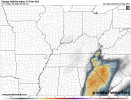
Dotted line indicates the approximate location of that boundary.

Equus
Member
More relevant to the above comment than this thread but there's an excellent paper detailing that 4/27/11 mesoscale boundary interaction that I like to revisit a lot, found here as a PDF
Mesoscale factors can be quite important for tornado days
Mesoscale factors can be quite important for tornado days
I’ll check that out thanks for linking @Equus
Looking at the latest GFS run and soundings for the 3rd/4th, those LLLRs around Arkansas, N Louisiana and West Mississippi aren’t really anything to write home about (I usually like to see 6.2+ but that’s just my own personal thing) and it’s only one factor.
This has a nice broad warm sector though so I’m interested in seeing how the instability progresses this week.
Some of those readings as it “marches to the sea” over SC, W GA, and NC are pretty eye catching.
Last edited:
Timhsv
Member

Just wow.....
Equus
Member
Interested in seeing if some of the obscenely low pressures modeling suggests come close to verifying as we'd no doubt set numerous pressure records
Wow thats quite the closed low. For now it looks like the action will be east of i65 but I wouldn't be surprised if the whole thing slows down...but also wonder if the low will start to occlude.
Austin Dawg
Member
Remember Jackson radar is still down until Friday. They usually finish these upgrades a few days early, so I except it be up and running by Thursday night.

Gail
Member

...DISCUSSION...
...Thursday/Day 4...
A regional outbreak of severe weather appears increasingly likely
Thursday afternoon and Thursday night including the potential for
large hail, damaging winds, and tornadoes, some of which may be
strong. Available guidance is in ample general agreement with the
east/northeastward-ejection of an upper trough from the southern
Rockies early Thursday to the Ozarks/ArkLaTex by late Thursday
night. Owing to a stalling/decaying front early this week,
respectable low-level moisture will exist across much of the Deep
South in advance of this approaching upper-level system and its
related intense deep-layer wind field. Current thinking is that this
severe potential should steadily increase across central/eastern
Texas and possibly southeast Oklahoma during the day. This risk
should only increase/further organize into Thursday evening across
the ArkLaTex/ArkLaMiss and Lower Mississippi Valley, and eventually
the Tennessee Valley late Thursday night.
Something that's not being talked about is a potent MCS moving through central Alabama and missippi going north the day before or the morning before.
Lake Martin EF4
Member
Hmmmm....A morning MCS followed by an intense outbreak in Dixie...Something that's not being talked about is a potent MCS moving through central Alabama and missippi going north the day before or the morning before.
Where have we seen that before?
Yep plenty to worry about unfortunately.
May move through north Alabama and north missippi thought it was Central
keithGA
Member
Interesting tidbit from the overnight AFD from FFC:
The next significant weather system begins to come together on
Thursday night/Friday morning as a deep, stout shortwave digs
into the Southern Plains. This shortwave will rapidly organize a
strong surface low pressure system, with organized frontal
boundaries that is progged to be centered somewhere around
the mid/lower Mississippi River Valley on Friday morning.
Compared to yesterday, the low pressures progression has risen
significantly towards the North and is beginning to show signals
of occlusion by the time the front reaches the NW corner of the
forecast area on Friday morning, which may undercut the potential
severity of the system with more limited upper-level support,
surface convergence, and instability than previously forecast.
(This change is similar to the frontal passage and severe threat
that this coming system on Monday has undergone) However,
significant values of severe parameters in regards to low- and
deep-level shear and moisture continue to be prevalent. Despite
some model uncertainty on timing and positioning, a 15% Convective
Outlook had been issued by SPC, based on the potential severity
of this system, and will need to be monitored closely through the
week.
The 00z euro is having a hard time saying this system even occludes lol.
- Thread starter
- #377
KevinH
Member
So far I am not concerned BECAUSE my area is not even in any risk category. That is why I was saying I hope the risk area doesn’t shift EAST.EHI from the 06z GFS. @KevinH this thing is hitting you and I at the wrong time.
Where in GA do you live? I am right on the AL/GA border (Columbus, GA).
I will take some rain, lightning and wind (as long as it is not ROTATING lol)
keithGA
Member
I'm about 40 miles east of ATL. The current SPC D5 encompasses the entire state.So far I am not concerned BECAUSE my area is not even in any risk category. That is why I was saying I hope the risk area doesn’t shift EAST.
Where in GA do you live? I am right on the AL/GA border (Columbus, GA).
I will take some rain, lightning and wind (as long as it is not ROTATING lol)
- Thread starter
- #379
KevinH
Member
Oh I forgot about D5.. ROFL! I was thinking about/so focused on D4 smhI'm about 40 miles east of ATL. The current SPC D5 encompasses the entire state.
I need to be off here until I am done waking up.
The euros almost non occlusion as well as the slowing trend like the GFS is pretty concerning for a prime time event for Alabama and Georgia for the day 5