
Navigation
Install the app
How to install the app on iOS
Follow along with the video below to see how to install our site as a web app on your home screen.
Note: This feature may not be available in some browsers.
More options
-
Welcome to TalkWeather! We see you lurking around TalkWeather! Take the extra step and join us today to view attachments, see less ads and maybe even join the discussion. CLICK TO JOIN TALKWEATHER
You are using an out of date browser. It may not display this or other websites correctly.
You should upgrade or use an alternative browser.
You should upgrade or use an alternative browser.
Severe WX Severe Wx Outbreak March 1st- 3rd, 2023 - Southern States, MS/OH/TN Valley
- Thread starter KevinH
- Start date


keithGA
Member
76kt storm motion. Gonna be scootin'.
ctopher5
Charter Member
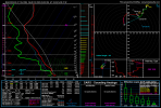
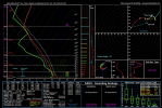
CIPS D4 shows 30% through TX, OK, MO, and MS. D5 shows 15% extending through MS, much of AL, GA, SC, and extending up through NC. Curious to see if higher probabilities extend into the areas highlighted in D5


Sent from my iPhone using Tapatalk
Sent from my iPhone using Tapatalk
Last edited:
xJownage
Member

Good lord CSU wyd?
45# on day 4 is absolutely ridiculous.
CheeselandSkies
Member
Sooo...00Z Friday (6 PM CST Thursday) is now within NAM range as of 12Z.
It appears to be less progressive with the system, with the surface low near Wichita Falls, TX at that time, and the forecast soundings along the dryline just as ominous as they have been on the GFS for many days now.
It's kind of interesting how the GFS went through that phase of drastically speeding up the system to the point where I was questioning if the warm sector was even gonna still be on land anywhere by the time of peak heating on Friday...now it doesn't seem out of the realm of possibility that Thursday trends to another TX/OK threat and Friday in MS/AL/GA (I personally am not forecasting this outcome as of yet, just pointing out that it seems to be back on the table).
Attachments
cincywx
Member
Sooo...00Z Friday (6 PM CST Thursday) is now within NAM range as of 12Z.
It appears to be less progressive with the system, with the surface low near Wichita Falls, TX at that time, and the forecast soundings along the dryline just as ominous as they have been on the GFS for many days now.
It's kind of interesting how the GFS went through that phase of drastically speeding up the system to the point where I was questioning if the warm sector was even gonna still be on land anywhere by the time of peak heating on Friday...now it doesn't seem out of the realm of possibility that Thursday trends to another TX/OK threat and Friday in MS/AL/GA (I personally am not forecasting this outcome as of yet, just pointing out that it seems to be back on the table).
this whole event could fall flat on its face but it still wouldnt change the fact that this sounding, like several others thus far, checks a lot of boxes you hate to see checked. very intriguing few days ahead.
CheeselandSkies
Member
I must have missed what happened in Cheyenne Oklahoma cause a tornado related fatality is being reported out of there.
You want this thread. Yes, there have been a lot of them lately. Also, sorry to hear that.
Svr Wx Threat Sun 2/26/2023 (KS, OK, TX, MO) & Mon 2/27/2023 (IL/IN/OH)
>1000 m2s2 of 0-1km and nearly 80kt at 1km, uhhhh yeah that will certainly do it
tornado examiner
Member
Whoops….I forgot to change the thread I thought I was on that one…You want this thread. Yes, there have been a lot of them lately. Also, sorry to hear that.

Svr Wx Threat Sun 2/26/2023 (KS, OK, TX, MO) & Mon 2/27/2023 (IL/IN/OH)
>1000 m2s2 of 0-1km and nearly 80kt at 1km, uhhhh yeah that will certainly do ittalkweather.com
Probably gunna see a large moderate/ enhanced risk tommorow on the day 3. Setting the stage for a high risk later on for missippi to east Texas.
tornado examiner
Member
Unlikely…..but possible…the last day 3 moderate was march 22 2022…Probably gunna see a large moderate risk tommorow on the day 3. Setting the stage for a high risk for missippi to east Texas.
Not
Not sure why it wouldn't lol, unless confidence decreases today. This is the type of wording you usually get for a moderate outlookUnlikely…..but possible…the last day 3 moderate was march 22 2022…
Attachments
xJownage
Member
NAM wants to move this entire setup into an OK/TX plains setup as it slows down the trough significantly. Some of the soundings i'm pulling up in SW OK/N TX are full on outbreak soundings...with high 3cape and insane kinematics given the thermodynamic profile. This is really catching my eye considering how the NAM has been so heavily underperforming on thermos recently.
- Thread starter
- #394
KevinH
Member
Well this could explain all of chatter I was seeing right before this thread was created. Good GRIEF.
Good lord CSU wyd?
45# on day 4 is absolutely ridiculous.
Now these #s are for SVR probably, what about TOR probs specifically?
I need to find this website (again).
CheeselandSkies
Member
As 12Z GFS rolls in...it remains considerably more progressive than the NAM (dryline MUCH further east over TX at FH084/00Z Friday) but just as potent as ever. Perhaps an even more dangerous setup for AR/LA/MS, if that closer proximity to the frontal forcing and the upper system allows for initiation further out in the warm sector Thursday evening.
I haven't really looked into what the mesoscale mechanisms for open warm sector initiation might be with this setup, since it's still pretty early for that and Trey's videos are usually good for that.")
I haven't really looked into what the mesoscale mechanisms for open warm sector initiation might be with this setup, since it's still pretty early for that and Trey's videos are usually good for that.
If a slowing trough evolution occurs / continues states east of Mississippi will likely have a higher chance at significant weather. Big trend to watch, especially if occlusion does not happen.
Extreme height falls is one. Which we haveAs 12Z GFS rolls in...it remains considerably more progressive than the NAM (dryline MUCH further east over TX at FH084/00Z Friday) but just as potent as ever. Perhaps an even more dangerous setup for AR/LA/MS, if that closer proximity to the frontal forcing and the upper system allows for initiation further out in the warm sector Thursday evening.
I haven't really looked into what the mesoscale mechanisms for open warm sector initiation might be with this setup, since it's still pretty early for that and Trey's videos are usually good for that.
CheeselandSkies
Member
Extreme height falls is one. Which we have
Height falls are more of a synoptic-scale feature associated with the big trough.
I'm looking more for things like subtle 700mb shortwaves (which it appears we might have one, check out the little kinks in the height contours over SE AR/SW MS at FH084), and surface confluence bands which are gonna be hard to pick out until we get well into hi-res CAM range.