• Welcome to TalkWeather!
    We see you lurking around TalkWeather! Take the extra step and join us today to view attachments, see less ads and maybe even join the discussion.
    CLICK TO JOIN TALKWEATHER

Severe Weather Threat November 1-3

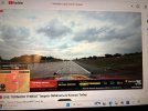
Freddy reporting blue skies west of Okc. I’ve missed tracking storms on laptop following along Copic.
 

Attachments

  • IMG_1993.jpeg
    IMG_1993.jpeg
    5 MB · Views: 7
Last edited:


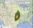
THE ENHANCED RISK FOR TORNADOES WAS EXPANDED SOUTH AND WEST INTO
PORTIONS OF CENTRAL OKLAHOMA TO ACCOUNT FOR RECENT OBSERVATIONAL
TRENDS AND SHORT-TERM FORECAST GUIDANCE, WHILE HAIL PROBABILITIES
WERE EXPANDED FURTHER NORTH AND EAST TO ACCOUNT FOR ONGOING ELEVATED
CONVECTION CAPABLE OF 1.00-1.50 INCH HAIL. GREATER UNCERTAINTY
EXISTS IN WHERE THE PRIMARY CORRIDOR OF DAMAGING WIND POTENTIAL WILL
MATERIALIZE, BUT LEADING EDGE BOWING SEGMENTS WILL BE CAPABLE OF
65-80 MPH DAMAGING WIND GUSTS.

..HALBERT-K.. 11/02/2026
 

Attachments

  • IMG_1994.jpeg
    IMG_1994.jpeg
    278 KB · Views: 7
Rear flank cell severe warned in OK is the main threat according to StormNet in the new term. Stuff down south OFD but any RFD nudgers will make this one interesting given the environment it is heading into.
 
I guess I'm a bit surprised by the eastward extension of the Marginal Risk for all of North MS and 2% tornado probability as well. Now, where's that switcharoo to turn off the magnet.....
 
That little arc of mini supercells near SE SD I was eying a few days ago on model guidance. Instability too low so I was like "nah"

And there it goes popping off tornadoes lmfao. StormNet has localized stronger probs near term and continues to suggest tor threat increasing again on that N OK storm but its looked cut off for a bit
 
That little arc of mini supercells near SE SD I was eying a few days ago on model guidance. Instability too low so I was like "nah"

And there it goes popping off tornadoes lmfao. StormNet has localized stronger probs near term and continues to suggest tor threat increasing again on that N OK storm but its looked cut off for a bit
Surprised to see it became not even any severe thunderstorm warnings.
 
Back
Top