- Thread starter
- #41

Kds86z
Member
Trey mentioned making the best out of last day of NAM. Rip
Follow along with the video below to see how to install our site as a web app on your home screen.
Note: This feature may not be available in some browsers.


Trey mentioned making the best out of last day of NAM. Rip
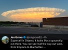
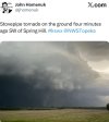
Could be but maybe more a lightning bolt dark frame type dealio.Today actually looks like a decent chance for some tornados that could be chased and with some visibility? First time in many months?


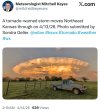
StormNet's biggest update has arguably changed things up massively. There is now a (temporally free) 12 hr ahead CAM that displays convection and i heavily recommend that all of you use it during this event to give a idea of how stuff will go. The tool has proven extremely successful on arguably the most surprising underforecast of the year. The E KS tornadoes on April 13th. no CAM was consistent on those supercells. All five members of StormNet caught >35 DBZ storms in the exact area. It may seem like I'm promoting StormNet but realistically, this is ground breaking in someway. Even more than any other update because there's now a CAM to associate with it so we get a idea of what it's seeing with storm mode and etc.
https://opensnow.com/stormnet?basem...ype=1&risk=tornado&site=KICT&product=velocity
And regarding its performance:
Without the premium feature, you can still use it 2 hrs ahead for free, which imo is still extremely impressive. We are in a golden age of weather forecasting, man.