• Welcome to TalkWeather!
    We see you lurking around TalkWeather! Take the extra step and join us today to view attachments, see less ads and maybe even join the discussion.
    CLICK TO JOIN TALKWEATHER

Severe Weather Threat November 1-3

For reasons listed above by Lep and Kakashi, I'm not overly keen on this event performing too strongly, but I feel like the ceiling is fairly high here if things pan out correctly for the storms. I haven't read the discussion because I'm knee-deep in research at the moment (I probably shouldn't even be paying too much attention to this right now, lol, I am anyways) but perhaps that is part of the reason why they went with a 10# here.
 
We'll see if the cap inhibits convection enough for things to stay discreet, and if any cells manage to avoid being absorbed by the line. Would not be at all surprised by a strong tornado, but overall it's a relatively common second season setup. There's going to be quite a few of these this year.
 
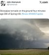
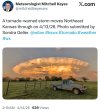
StormNet's biggest update has arguably changed things up massively. There is now a (temporally free) 12 hr ahead CAM that displays convection and i heavily recommend that all of you use it during this event to give a idea of how stuff will go. The tool has proven extremely successful on arguably the most surprising underforecast of the year. The E KS tornadoes on April 13th. no CAM was consistent on those supercells. All five members of StormNet caught >35 DBZ storms in the exact area. It may seem like I'm promoting StormNet but realistically, this is ground breaking in someway. Even more than any other update because there's now a CAM to associate with it so we get a idea of what it's seeing with storm mode and etc.
https://opensnow.com/stormnet?basem...ype=1&risk=tornado&site=KICT&product=velocity

And regarding its performance:


Without the premium feature, you can still use it 2 hrs ahead for free, which imo is still extremely impressive. We are in a golden age of weather forecasting, man.
 
StormNet's biggest update has arguably changed things up massively. There is now a (temporally free) 12 hr ahead CAM that displays convection and i heavily recommend that all of you use it during this event to give a idea of how stuff will go. The tool has proven extremely successful on arguably the most surprising underforecast of the year. The E KS tornadoes on April 13th. no CAM was consistent on those supercells. All five members of StormNet caught >35 DBZ storms in the exact area. It may seem like I'm promoting StormNet but realistically, this is ground breaking in someway. Even more than any other update because there's now a CAM to associate with it so we get a idea of what it's seeing with storm mode and etc.
https://opensnow.com/stormnet?basem...ype=1&risk=tornado&site=KICT&product=velocity

And regarding its performance:


Without the premium feature, you can still use it 2 hrs ahead for free, which imo is still extremely impressive. We are in a golden age of weather forecasting, man.

I remember April 13! Wild.
 

Attachments

  • IMG_6883.jpeg
    IMG_6883.jpeg
    112.3 KB · Views: 9
  • IMG_7546.jpeg
    IMG_7546.jpeg
    107 KB · Views: 8
  • IMG_7080.jpeg
    IMG_7080.jpeg
    161.9 KB · Views: 11
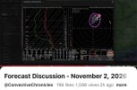
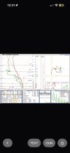
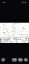
I think 12z looks somewhat similar to earlier but with improvements with the environment with kinematics the hodograph thermos beginning to destabilize and moistening still need to work on lapse rates I think top environment is struggling all still have time to improve maybe I think oun might be the best one for now ddc environment looks good too need to destabilise and moistening in the low levels still have wonkiness in the hodograph
 

Attachments

  • IMG_7116.jpeg
    IMG_7116.jpeg
    398.7 KB · Views: 6
  • IMG_7117.jpeg
    IMG_7117.jpeg
    401.1 KB · Views: 6
  • IMG_7118.jpeg
    IMG_7118.jpeg
    390.4 KB · Views: 5
Back
Top