
warneagle
Member
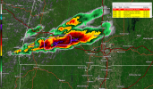
Doesn’t look like there’s really enough low-level shear for any of these storms away from the surface low to do much. Plenty of discrete convection but they look pretty strung out.
Follow along with the video below to see how to install our site as a web app on your home screen.
Note: This feature may not be available in some browsers.
Exactly. Large hail threat.Doesn’t look like there’s really enough low-level shear for any of these storms away from the surface low to do much. Plenty of discrete convection but they look pretty strung out.
Severe warned now!I'm about to get pummeled by over 1 inch hail and gusty winds here in western MA. First real storm of the season.
Stay safe!Severe warned now!

Tor warned
Yeah any kind of substantial tornado threat is really gonna be dependent on boundaries and mesoscale factors so I totally get the lower probabilities. Any kind of local enhancement of low-level shear could be an issue though.One of those days that if the low level flow was just a bit stronger, it would get very ugly very quickly. I think the expansive nature of the strong instability/sufficient deep layer shear environment with quite a few storms warrants the probabilities issued, since I'd have to imagine at least a few storms will produce tornadoes via boundaries/storm mergers/etc. Greatest concern for me would be across portions of TN and S KY later, although I could see southern MO having some chances in the next few hours as supercells move towards Springfield.

.png")